Criquebeuf-en-Caux
Criquebeuf-en-Caux is a commune in the Seine-Maritime department in the Normandy region in northern France.
Criquebeuf-en-Caux | |
|---|---|
 A general view of Criquebeuf-en-Caux | |
 Coat of arms | |
Location of Criquebeuf-en-Caux 
| |
 Criquebeuf-en-Caux  Criquebeuf-en-Caux | |
| Coordinates: 49°44′28″N 0°20′01″E | |
| Country | France |
| Region | Normandy |
| Department | Seine-Maritime |
| Arrondissement | Le Havre |
| Canton | Fécamp |
| Intercommunality | CA Fécamp Caux Littoral |
| Government | |
| • Mayor (2020–2026) | Ludovic Bacq[1] |
| Area 1 | 2.08 km2 (0.80 sq mi) |
| Population (2017-01-01)[2] | 404 |
| • Density | 190/km2 (500/sq mi) |
| Time zone | UTC+01:00 (CET) |
| • Summer (DST) | UTC+02:00 (CEST) |
| INSEE/Postal code | 76194 /76111 |
| Elevation | 5–102 m (16–335 ft) (avg. 102 m or 335 ft) |
| 1 French Land Register data, which excludes lakes, ponds, glaciers > 1 km2 (0.386 sq mi or 247 acres) and river estuaries. | |
Geography
The commune is centered on a farming village situated in the Pays de Caux, some 25 miles (40 km) northeast of Le Havre, at the junction of the D211 and D940 roads. The commune's cliffs face the English Channel.
Heraldry
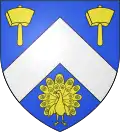
Arms of Criquebeuf-en-Caux |
The arms of Criquebeuf-en-Caux are blazoned : Azure, a chevron argent between 2 mallets and a peacock in his pride Or. |
Population
| Year | 1962 | 1968 | 1975 | 1982 | 1990 | 1999 | 2006 | 2007 | 2012 | 2015 |
|---|---|---|---|---|---|---|---|---|---|---|
| Population | 144 | 170 | 197 | 275 | 417 | 403 | 393 | 391 | 347 | 371 |
| From the year 1962 on: No double counting—residents of multiple communes (e.g. students and military personnel) are counted only once. | ||||||||||
Places of interest
References
- "Répertoire national des élus: les maires". data.gouv.fr, Plateforme ouverte des données publiques françaises (in French). 2 December 2020. Retrieved 7 December 2020.
- "Populations légales 2017". INSEE. Retrieved 6 January 2020.
| Wikimedia Commons has media related to Criquebeuf-en-Caux. |
| Authority control |
|---|
This article is issued from Wikipedia. The text is licensed under Creative Commons - Attribution - Sharealike. Additional terms may apply for the media files.