Saint-Germain-des-Essourts
Saint-Germain-des-Essourts is a commune in the Seine-Maritime department in the Normandy region in northern France.
Saint-Germain-des-Essourts | |
|---|---|
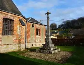 The cemetery cross in Saint-Germain-des-Essourts | |
Location of Saint-Germain-des-Essourts 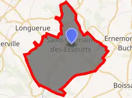
| |
 Saint-Germain-des-Essourts  Saint-Germain-des-Essourts | |
| Coordinates: 49°32′22″N 1°19′14″E | |
| Country | France |
| Region | Normandy |
| Department | Seine-Maritime |
| Arrondissement | Rouen |
| Canton | Le Mesnil-Esnard |
| Government | |
| • Mayor (2020–2026) | Alain Burette[1] |
| Area 1 | 9.37 km2 (3.62 sq mi) |
| Population (2017-01-01)[2] | 406 |
| • Density | 43/km2 (110/sq mi) |
| Time zone | UTC+01:00 (CET) |
| • Summer (DST) | UTC+02:00 (CEST) |
| INSEE/Postal code | 76581 /76750 |
| Elevation | 101–171 m (331–561 ft) (avg. 128 m or 420 ft) |
| 1 French Land Register data, which excludes lakes, ponds, glaciers > 1 km2 (0.386 sq mi or 247 acres) and river estuaries. | |
Geography
A farming village situated in the Pays de Bray, some 14 miles (23 km) northeast of Rouen at the junction of the D98 with the D87 and the D7 with the D61 roads. The commune's territory is the source of the river Crevon, a small tributary of the Andelle river.
Population
| Year | Pop. | ±% p.a. |
|---|---|---|
| 1968 | 245 | — |
| 1975 | 247 | +0.12% |
| 1982 | 247 | +0.00% |
| 1990 | 329 | +3.65% |
| 1999 | 352 | +0.75% |
| 2007 | 363 | +0.39% |
| 2012 | 400 | +1.96% |
| 2017 | 406 | +0.30% |
| Source: INSEE[3] | ||
Places of interest
- The church of St. Germain, dating from the nineteenth century.
- A sixteenth-century stone cross.
- The nineteenth-century chateau of Fontaine-Châtel.
- The chateau of Bimare.
- The chapel of St. Austreberthe.
References
- "Répertoire national des élus: les maires". data.gouv.fr, Plateforme ouverte des données publiques françaises (in French). 2 December 2020. Retrieved 7 December 2020.
- "Populations légales 2017". INSEE. Retrieved 6 January 2020.
- Population en historique depuis 1968, INSEE
| Wikimedia Commons has media related to Saint-Germain-des-Essourts. |
| Authority control |
|---|
This article is issued from Wikipedia. The text is licensed under Creative Commons - Attribution - Sharealike. Additional terms may apply for the media files.