Grémonville
Grémonville is a commune in the Seine-Maritime department in the Normandy region in northern France.
Grémonville | |
|---|---|
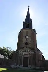 The church in Grémonville | |
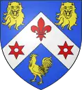 Coat of arms | |
Location of Grémonville 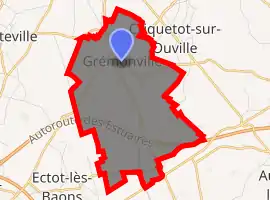
| |
 Grémonville  Grémonville | |
| Coordinates: 49°40′17″N 0°49′39″E | |
| Country | France |
| Region | Normandy |
| Department | Seine-Maritime |
| Arrondissement | Rouen |
| Canton | Yvetot |
| Intercommunality | CC Plateau de Caux-Doudeville-Yerville |
| Government | |
| • Mayor (2020–2026) | Daniel Beuzelin |
| Area 1 | 8.27 km2 (3.19 sq mi) |
| Population (2017-01-01)[1] | 433 |
| • Density | 52/km2 (140/sq mi) |
| Time zone | UTC+01:00 (CET) |
| • Summer (DST) | UTC+02:00 (CEST) |
| INSEE/Postal code | 76325 /76970 |
| Elevation | 133–167 m (436–548 ft) (avg. 160 m or 520 ft) |
| 1 French Land Register data, which excludes lakes, ponds, glaciers > 1 km2 (0.386 sq mi or 247 acres) and river estuaries. | |
Geography
A farming village situated some 19 miles (31 km) northwest of Rouen, at the junction of the D20, D55 and the D253 roads. The A29 autoroute passes through the southern section of the commune's territory.
Heraldry
Arms of Grémonville |
The arms of Grémonville are blazoned : Azure, on a chevron argent between 2 leopard heads affronty and a cock, a fleur-de-lys between 2 spur rowels gules. |
Population
| Year | 1962 | 1968 | 1975 | 1982 | 1990 | 1999 | 2006 |
|---|---|---|---|---|---|---|---|
| Population | 303 | 333 | 346 | 401 | 452 | 393 | 404 |
| From the year 1962 on: No double counting—residents of multiple communes (e.g. students and military personnel) are counted only once. | |||||||
Places of interest
- The church of Sts.Pierre and Paul, dating from the eighteenth century.
- A seventeenth-century château in Louis XIII style.
- A chapel, built on the site of the old priory.
Notable people
- Micheline Ostermeyer, (1922–2001), a track and field athlete and pianist, spent her last years here.
References
- "Populations légales 2017". INSEE. Retrieved 6 January 2020.
| Wikimedia Commons has media related to Grémonville. |
| Authority control |
|---|
This article is issued from Wikipedia. The text is licensed under Creative Commons - Attribution - Sharealike. Additional terms may apply for the media files.