Ourville-en-Caux
Ourville-en-Caux is a commune in the Seine-Maritime department in the Normandy region in northern France.
Ourville-en-Caux | |
|---|---|
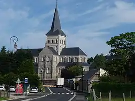 The church in Ourville-en-Caux | |
 Coat of arms | |
Location of Ourville-en-Caux 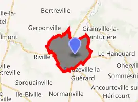
| |
 Ourville-en-Caux  Ourville-en-Caux | |
| Coordinates: 49°43′47″N 0°36′23″E | |
| Country | France |
| Region | Normandy |
| Department | Seine-Maritime |
| Arrondissement | Dieppe |
| Canton | Saint-Valery-en-Caux |
| Intercommunality | CC Côte d'Albâtre |
| Government | |
| • Mayor (2020–2026) | Jerôme Douillet |
| Area 1 | 9.86 km2 (3.81 sq mi) |
| Population (2017-01-01)[1] | 1,146 |
| • Density | 120/km2 (300/sq mi) |
| Time zone | UTC+01:00 (CET) |
| • Summer (DST) | UTC+02:00 (CEST) |
| INSEE/Postal code | 76490 /76450 |
| Elevation | 55–135 m (180–443 ft) (avg. 110 m or 360 ft) |
| 1 French Land Register data, which excludes lakes, ponds, glaciers > 1 km2 (0.386 sq mi or 247 acres) and river estuaries. | |
Geography
A farming village with a little light industry, in the Pays de Caux, situated some 30 miles (48 km) northeast of Le Havre, at the junction of the D5, D50, D28 and D75.
Heraldry
Arms of Ourville-en-Caux |
The arms of Ourville-en-Caux are blazoned : Quarterly: 1st, Vert a cow's head caboshed Argent; 2nd, Argent a dexter forearm in pale bearing a torch all Azure, 3rd, Argent a flax flower Azure; 4th Vert a sheep's head caboshed Argent. |
Population
| Year | Pop. | ±% p.a. |
|---|---|---|
| 1968 | 693 | — |
| 1975 | 756 | +1.25% |
| 1982 | 896 | +2.46% |
| 1990 | 933 | +0.51% |
| 1999 | 1,041 | +1.22% |
| 2007 | 1,104 | +0.74% |
| 2012 | 1,084 | −0.36% |
| 2017 | 1,146 | +1.12% |
| Source: INSEE[2] | ||
Places of interest
- The church, dating from the nineteenth century.
References
- "Populations légales 2017". INSEE. Retrieved 6 January 2020.
- Population en historique depuis 1968, INSEE
| Wikimedia Commons has media related to Ourville-en-Caux. |
| Authority control |
|---|
This article is issued from Wikipedia. The text is licensed under Creative Commons - Attribution - Sharealike. Additional terms may apply for the media files.