Heurteauville
Heurteauville is a commune in the Seine-Maritime department in the Normandie region in north-western France.
Heurteauville | |
|---|---|
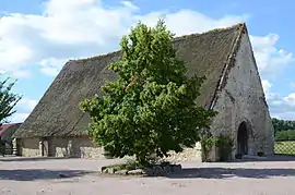 A tithe barn in Heurteauville | |
.svg.png.webp) Coat of arms | |
Location of Heurteauville 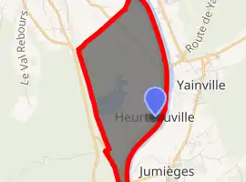
| |
 Heurteauville  Heurteauville | |
| Coordinates: 49°26′43″N 0°48′51″E | |
| Country | France |
| Region | Normandy |
| Department | Seine-Maritime |
| Arrondissement | Rouen |
| Canton | Port-Jérôme-sur-Seine |
| Intercommunality | CA Caux vallée de Seine |
| Government | |
| • Mayor (2020–2026) | Gérard Lenormand[1] |
| Area 1 | 7.26 km2 (2.80 sq mi) |
| Population (2017-01-01)[2] | 310 |
| • Density | 43/km2 (110/sq mi) |
| Time zone | UTC+01:00 (CET) |
| • Summer (DST) | UTC+02:00 (CEST) |
| INSEE/Postal code | 76362 /76940 |
| Elevation | 0–80 m (0–262 ft) (avg. 4 m or 13 ft) |
| 1 French Land Register data, which excludes lakes, ponds, glaciers > 1 km2 (0.386 sq mi or 247 acres) and river estuaries. | |
Geography
A farming village situated in a meander of the river Seine, some 12 miles (19 km) west of Rouen, on the D65 road.
Old peat bogs have been preserved as a nature reserve alongside the forest.
The commune is thought to be unique in France for having two separate ferry services over the river.
Population
|
|
References
- Liste des maires du département de la Seine-Maritime, 10 August 2020
- "Populations légales 2017". INSEE. Retrieved 6 January 2020.
External links
| Wikimedia Commons has media related to Heurteauville. |
- Site de la Commune(in French)
- Site Facebook de la Commune(in French)
- Site Facebook des jardins de la Commune(in French)
| Authority control |
|---|
This article is issued from Wikipedia. The text is licensed under Creative Commons - Attribution - Sharealike. Additional terms may apply for the media files.