Sainte-Austreberthe, Seine-Maritime
Sainte-Austreberthe is a commune in the Seine-Maritime department in the Normandy region in northern France.
Sainte-Austreberthe | |
|---|---|
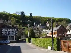 A view within Sainte-Austreberthe | |
.svg.png.webp) Coat of arms | |
Location of Sainte-Austreberthe 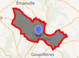
| |
 Sainte-Austreberthe  Sainte-Austreberthe | |
| Coordinates: 49°35′55″N 0°58′31″E | |
| Country | France |
| Region | Normandy |
| Department | Seine-Maritime |
| Arrondissement | Rouen |
| Canton | Notre-Dame-de-Bondeville |
| Government | |
| • Mayor (2020–2026) | Daniel Gressent[1] |
| Area 1 | 6.13 km2 (2.37 sq mi) |
| Population (2017-01-01)[2] | 612 |
| • Density | 100/km2 (260/sq mi) |
| Time zone | UTC+01:00 (CET) |
| • Summer (DST) | UTC+02:00 (CEST) |
| INSEE/Postal code | 76566 /76570 |
| Elevation | 77–168 m (253–551 ft) (avg. 85 m or 279 ft) |
| 1 French Land Register data, which excludes lakes, ponds, glaciers > 1 km2 (0.386 sq mi or 247 acres) and river estuaries. | |
Geography
A village of farming and forestry situated by the banks of the Austreberthe River, some 14 miles (23 km) northwest of Rouen at the junction of the D22, D53 and the D103 roads.
Heraldry
Arms of Sainte-Austreberthe |
The arms of Sainte-Austreberthe are blazoned : Or, St. Austreberthe argent vested proper, holding a crozier sable in her left hand, a wolf ??? overlying her feet, and on a chief vert a fess wavy argent. |
Population
| Year | 1962 | 1968 | 1975 | 1982 | 1990 | 1999 | 2006 |
|---|---|---|---|---|---|---|---|
| Population | 342 | 416 | 545 | 453 | 521 | 583 | 595 |
| From the year 1962 on: No double counting—residents of multiple communes (e.g. students and military personnel) are counted only once. | |||||||
Places of interest
- The church of St. Austreberthe, dating from the eleventh century.
- The chateau of Langrume.
- The sixteenth-century stone cross in the cemetery.
References
- Liste des maires du département de la Seine-Maritime, 10 August 2020
- "Populations légales 2017". INSEE. Retrieved 6 January 2020.
| Wikimedia Commons has media related to Sainte-Austreberthe, Seine-Maritime. |
| Authority control |
|---|
This article is issued from Wikipedia. The text is licensed under Creative Commons - Attribution - Sharealike. Additional terms may apply for the media files.