Dampierre-Saint-Nicolas
Dampierre-Saint-Nicolas is a commune in the Seine-Maritime department in the Normandy region in northern France.
Dampierre-Saint-Nicolas | |
|---|---|
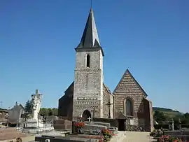 The church in Dampierre-Saint-Nicolas | |
.svg.png.webp) Coat of arms | |
Location of Dampierre-Saint-Nicolas 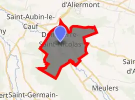
| |
 Dampierre-Saint-Nicolas  Dampierre-Saint-Nicolas | |
| Coordinates: 49°51′37″N 1°12′03″E | |
| Country | France |
| Region | Normandy |
| Department | Seine-Maritime |
| Arrondissement | Dieppe |
| Canton | Dieppe-2 |
| Intercommunality | CC Falaises du Talou |
| Government | |
| • Mayor (2008–2014) | Jean-Yves Henaff |
| Area 1 | 3.94 km2 (1.52 sq mi) |
| Population (2017-01-01)[1] | 472 |
| • Density | 120/km2 (310/sq mi) |
| Time zone | UTC+01:00 (CET) |
| • Summer (DST) | UTC+02:00 (CEST) |
| INSEE/Postal code | 76210 /76510 |
| Elevation | 14–136 m (46–446 ft) (avg. 15 m or 49 ft) |
| 1 French Land Register data, which excludes lakes, ponds, glaciers > 1 km2 (0.386 sq mi or 247 acres) and river estuaries. | |
Geography
A farming village situated by the banks of the river Béthune in the Pays de Caux, some 5 miles (8.0 km) southeast of Dieppe, at the junction of the D1 and the D114 roads.
Population
| Year | 1962 | 1968 | 1975 | 1982 | 1990 | 1999 | 2006 |
|---|---|---|---|---|---|---|---|
| Population | 333 | 396 | 509 | 510 | 515 | 483 | 517 |
| From the year 1962 on: No double counting—residents of multiple communes (e.g. students and military personnel) are counted only once. | |||||||
Places of interest
- The church of St.Pierre & St.Paul, dating from the thirteenth century.
- Remains of a 19th-century chateau.
- A seventeenth-century manorhouse.
References
- "Populations légales 2017". INSEE. Retrieved 6 January 2020.
External links
| Wikimedia Commons has media related to Dampierre-Saint-Nicolas. |
- Official commune website (in French)
| Authority control |
|---|
This article is issued from Wikipedia. The text is licensed under Creative Commons - Attribution - Sharealike. Additional terms may apply for the media files.