Saint-Nicolas-de-la-Haie
Saint-Nicolas-de-la-Haie is a commune in the Seine-Maritime department in the Normandy region in northern France.
Saint-Nicolas-de-la-Haie | |
|---|---|
 Coat of arms | |
Location of Saint-Nicolas-de-la-Haie 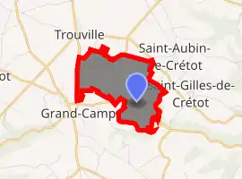
| |
 Saint-Nicolas-de-la-Haie  Saint-Nicolas-de-la-Haie | |
| Coordinates: 49°33′25″N 0°37′26″E | |
| Country | France |
| Region | Normandy |
| Department | Seine-Maritime |
| Arrondissement | Rouen |
| Canton | Port-Jérôme-sur-Seine |
| Intercommunality | CA Caux vallée de Seine |
| Government | |
| • Mayor (2020–2026) | Gilles Amat[1] |
| Area 1 | 3.15 km2 (1.22 sq mi) |
| Population (2017-01-01)[2] | 413 |
| • Density | 130/km2 (340/sq mi) |
| Time zone | UTC+01:00 (CET) |
| • Summer (DST) | UTC+02:00 (CEST) |
| INSEE/Postal code | 76626 /76490 |
| Elevation | 77–150 m (253–492 ft) (avg. 120 m or 390 ft) |
| 1 French Land Register data, which excludes lakes, ponds, glaciers > 1 km2 (0.386 sq mi or 247 acres) and river estuaries. | |
Geography
A farming village situated in the Pays de Caux, some 26 miles (42 km) northwest of Rouen on the D34 and the D30.
Heraldry
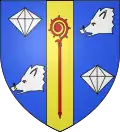
Arms of Saint-Nicolas-de-la-Haie |
The arms of Saint-Nicolas-de-la-Haie are blazoned : Azure, on a pale Or between in bend 2 diamonds and in bend sinister 2 boars' heads argent, an abbatial crozier gules. |
Population
| Year | Pop. | ±% p.a. |
|---|---|---|
| 1968 | 178 | — |
| 1975 | 176 | −0.16% |
| 1982 | 268 | +6.19% |
| 1990 | 348 | +3.32% |
| 1999 | 379 | +0.95% |
| 2007 | 397 | +0.58% |
| 2012 | 404 | +0.35% |
| 2017 | 413 | +0.44% |
| Source: INSEE[3] | ||
Places of interest
- The church of St. Nicholas, dating from the twelfth century.
References
- Liste des maires du département de la Seine-Maritime, 10 August 2020
- "Populations légales 2017". INSEE. Retrieved 6 January 2020.
- Population en historique depuis 1968, INSEE
| Wikimedia Commons has media related to Saint-Nicolas-de-la-Haie. |
| Authority control |
|---|
This article is issued from Wikipedia. The text is licensed under Creative Commons - Attribution - Sharealike. Additional terms may apply for the media files.