La Houssaye-Béranger
La Houssaye-Béranger is a commune in the Seine-Maritime department in the Normandy region in northern France.
La Houssaye-Béranger | |
|---|---|
 Coat of arms | |
Location of La Houssaye-Béranger 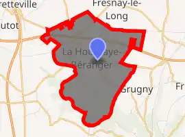
| |
 La Houssaye-Béranger  La Houssaye-Béranger | |
| Coordinates: 49°37′54″N 1°05′11″E | |
| Country | France |
| Region | Normandy |
| Department | Seine-Maritime |
| Arrondissement | Rouen |
| Canton | Bois-Guillaume |
| Government | |
| • Mayor (2008–2014) | Jean Vasseur |
| Area 1 | 8.06 km2 (3.11 sq mi) |
| Population (2017-01-01)[1] | 534 |
| • Density | 66/km2 (170/sq mi) |
| Time zone | UTC+01:00 (CET) |
| • Summer (DST) | UTC+02:00 (CEST) |
| INSEE/Postal code | 76369 /76690 |
| Elevation | 116–179 m (381–587 ft) (avg. 169 m or 554 ft) |
| 1 French Land Register data, which excludes lakes, ponds, glaciers > 1 km2 (0.386 sq mi or 247 acres) and river estuaries. | |
Geography
A forestry and farming village situated in the Pays de Caux, some 16 miles (26 km) north of Rouen, at the junction of the D2, D90 and the D97 roads.
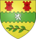
Heraldry
Arms of La Houssaye-Béranger |
The arms of La Houssaye-Béranger are blazoned : Azure, a chevron argent between 2 anchors and a cow passant Or, a chief per pale 1 Gules, a mitre Or, and 2 paly Or and gules. |
Population
| Year | 1962 | 1968 | 1975 | 1982 | 1990 | 1999 | 2006 |
|---|---|---|---|---|---|---|---|
| Population | 252 | 264 | 260 | 360 | 427 | 498 | 533 |
| From the year 1962 on: No double counting—residents of multiple communes (e.g. students and military personnel) are counted only once. | |||||||
Places of interest
- The church of St. Pierre, dating from the twelfth century.
References
- "Populations légales 2017". INSEE. Retrieved 6 January 2020.
| Wikimedia Commons has media related to La Houssaye-Béranger. |
| Authority control |
|---|
This article is issued from Wikipedia. The text is licensed under Creative Commons - Attribution - Sharealike. Additional terms may apply for the media files.