Longueil, Seine-Maritime
Longueil is a commune in the Seine-Maritime department in the Normandy region in northern France.
Longueil | |
|---|---|
 Saint-Pierre Church | |
 Coat of arms | |
Location of Longueil 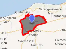
| |
 Longueil  Longueil | |
| Coordinates: 49°53′01″N 0°56′59″E | |
| Country | France |
| Region | Normandy |
| Department | Seine-Maritime |
| Arrondissement | Dieppe |
| Canton | Dieppe-1 |
| Intercommunality | CC Terroir de Caux |
| Government | |
| • Mayor (2020–2026) | Didier Ledrait |
| Area 1 | 11.73 km2 (4.53 sq mi) |
| Population (2017-01-01)[1] | 561 |
| • Density | 48/km2 (120/sq mi) |
| Time zone | UTC+01:00 (CET) |
| • Summer (DST) | UTC+02:00 (CEST) |
| INSEE/Postal code | 76395 /76860 |
| Elevation | 1–69 m (3.3–226.4 ft) (avg. 7 m or 23 ft) |
| 1 French Land Register data, which excludes lakes, ponds, glaciers > 1 km2 (0.386 sq mi or 247 acres) and river estuaries. | |
Geography
A farming village situated by the banks of the river Saâne in the Pays de Caux, some 9 miles (14 km) southwest of Dieppe on the D 27 and the D 925 at its junction with the D 127 road.
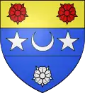
Coat of arms
Arms of Longueil |
The arms of Longueil are blazoned : tierced per fess 1: Or, 2 roses gules; 2: Azure, a crescent between 2 mullets argent; 3: Azure, a rose argent. |
Population
| Year | Pop. | ±% p.a. |
|---|---|---|
| 1968 | 620 | — |
| 1975 | 618 | −0.05% |
| 1982 | 579 | −0.93% |
| 1990 | 516 | −1.43% |
| 1999 | 513 | −0.06% |
| 2007 | 550 | +0.87% |
| 2012 | 577 | +0.96% |
| 2017 | 561 | −0.56% |
| Source: INSEE[2] | ||
Places of interest
- The church of Saint-Pierre, dating from the 13th and 16th century.
- Ruins of an 11th and 12th century castle.
References
- "Populations légales 2017". INSEE. Retrieved 6 January 2020.
- Population en historique depuis 1968, INSEE
| Wikimedia Commons has media related to Longueil. |
| Authority control |
|---|
This article is issued from Wikipedia. The text is licensed under Creative Commons - Attribution - Sharealike. Additional terms may apply for the media files.