Vattetot-sous-Beaumont
Vattetot-sous-Beaumont is a commune in the Seine-Maritime department in the Normandy region in northern France.
Vattetot-sous-Beaumont | |
|---|---|
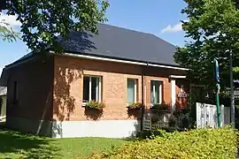 The town hall in Vattetot-sous-Beaumont | |
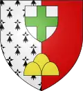 Coat of arms | |
Location of Vattetot-sous-Beaumont 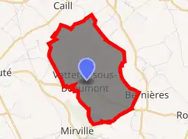
| |
 Vattetot-sous-Beaumont  Vattetot-sous-Beaumont | |
| Coordinates: 49°37′34″N 0°26′50″E | |
| Country | France |
| Region | Normandy |
| Department | Seine-Maritime |
| Arrondissement | Le Havre |
| Canton | Saint-Romain-de-Colbosc |
| Intercommunality | CC Campagne de Caux |
| Government | |
| • Mayor (2020–2026) | Hervé Niepceron[1] |
| Area 1 | 6.94 km2 (2.68 sq mi) |
| Population (2017-01-01)[2] | 576 |
| • Density | 83/km2 (210/sq mi) |
| Time zone | UTC+01:00 (CET) |
| • Summer (DST) | UTC+02:00 (CEST) |
| INSEE/Postal code | 76725 /76110 |
| Elevation | 93–147 m (305–482 ft) (avg. 140 m or 460 ft) |
| 1 French Land Register data, which excludes lakes, ponds, glaciers > 1 km2 (0.386 sq mi or 247 acres) and river estuaries. | |
Geography
A farming village in the Pays de Caux, situated some 20 miles (32 km) northeast of Le Havre, on the D52 road.
Heraldry
Arms of Vattetot-sous-Beaumont |
The arms of the commune of Vattetot-sous-Beaumont are blazoned : Per pale ermine and gules, a 3-peaked mount (NOT issuant from base), and in chief on an inescutcheon argent, a cross vert. |
Population
| Year | 1962 | 1968 | 1975 | 1982 | 1990 | 1999 | 2006 |
|---|---|---|---|---|---|---|---|
| Population | 327 | 345 | 279 | 361 | 484 | 490 | 533 |
| From the year 1962 on: No double counting—residents of multiple communes (e.g. students and military personnel) are counted only once. | |||||||
Places of interest
- The church of Notre-Dame, dating from the thirteenth century.
- The thirteenth-century Bailleul manorhouse.
References
- Liste des maires du département de la Seine-Maritime, 10 August 2020
- "Populations légales 2017". INSEE. Retrieved 6 January 2020.
| Wikimedia Commons has media related to Vattetot-sous-Beaumont. |
| Authority control |
|---|
This article is issued from Wikipedia. The text is licensed under Creative Commons - Attribution - Sharealike. Additional terms may apply for the media files.