Le Hanouard
Le Hanouard is a commune in the Seine-Maritime department in the Normandy region in northern France.
Le Hanouard | |
|---|---|
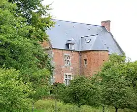 The manor of Le Hanouard | |
 Coat of arms | |
Location of Le Hanouard 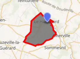
| |
 Le Hanouard  Le Hanouard | |
| Coordinates: 49°43′49″N 0°39′49″E | |
| Country | France |
| Region | Normandy |
| Department | Seine-Maritime |
| Arrondissement | Dieppe |
| Canton | Saint-Valery-en-Caux |
| Intercommunality | CC Côte d'Albâtre |
| Area 1 | 4.32 km2 (1.67 sq mi) |
| Population (2017-01-01)[1] | 249 |
| • Density | 58/km2 (150/sq mi) |
| Time zone | UTC+01:00 (CET) |
| • Summer (DST) | UTC+02:00 (CEST) |
| INSEE/Postal code | 76339 /76450 |
| Elevation | 36–142 m (118–466 ft) (avg. 85 m or 279 ft) |
| 1 French Land Register data, which excludes lakes, ponds, glaciers > 1 km2 (0.386 sq mi or 247 acres) and river estuaries. | |
Geography
A farming village surrounded by woodland in the Pays de Caux, some 32 miles (51 km) northeast of Le Havre, at the junction of the D131 and D109 roads and by the banks of the Durdent river.
Heraldry
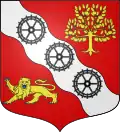
Arms of Le Hanouard |
The arms of Le Hanouard are blazoned : Gules, on a bend wavy argent between an apple tree and a leopard Or armed and langued azure, 3 millwheels sable. |
Population
| Year | 1962 | 1968 | 1975 | 1982 | 1990 | 1999 | 2006 |
|---|---|---|---|---|---|---|---|
| Population | 232 | 234 | 226 | 287 | 266 | 273 | 226 |
| From the year 1962 on: No double counting—residents of multiple communes (e.g. students and military personnel) are counted only once. | |||||||
Places of interest
- The church of St. Denis-et-Sainte-Cécile, dating from the seventeenth century.
References
- "Populations légales 2017". INSEE. Retrieved 6 January 2020.
| Wikimedia Commons has media related to Le Hanouard. |
| Authority control |
|---|
This article is issued from Wikipedia. The text is licensed under Creative Commons - Attribution - Sharealike. Additional terms may apply for the media files.