Cany-Barville
Cany-Barville is a commune in the Seine-Maritime department in the Normandy region in northern France.
Cany-Barville | |
|---|---|
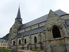 The church in Cany-Barville | |
 Coat of arms | |
Location of Cany-Barville 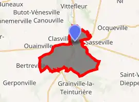
| |
 Cany-Barville  Cany-Barville | |
| Coordinates: 49°47′19″N 0°38′22″E | |
| Country | France |
| Region | Normandy |
| Department | Seine-Maritime |
| Arrondissement | Dieppe |
| Canton | Saint-Valery-en-Caux |
| Intercommunality | CC Côte d'Albâtre |
| Government | |
| • Mayor (2020–2026) | Jean-Pierre Thévenot |
| Area 1 | 13.57 km2 (5.24 sq mi) |
| Population (2017-01-01)[1] | 3,052 |
| • Density | 220/km2 (580/sq mi) |
| Time zone | UTC+01:00 (CET) |
| • Summer (DST) | UTC+02:00 (CEST) |
| INSEE/Postal code | 76159 /76450 |
| Elevation | 10–126 m (33–413 ft) (avg. 25 m or 82 ft) |
| 1 French Land Register data, which excludes lakes, ponds, glaciers > 1 km2 (0.386 sq mi or 247 acres) and river estuaries. | |
Geography
A farming and light industrial town situated by the banks of the river Durdent in the Pays de Caux, some 25 miles (40 km) southwest of Dieppe, at the junction of the D925, D10 and the D268 roads.
Heraldry
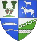
Arms of Cany-Barville |
The arms of Cany-Barville are blazoned : Quarterly 1: Argent, 2 garbs of wheat vert and an apple tree vert fructed gules; 2: Azure, a horse and in sinister chief a sheep argent; 3: Azure, a pike contourny and an eel contourny argent; 4: Argent, a hill filling most of the field, rising to sinister, with 5 trees at the top, vert, a fess wavy argent 'river'. [Really, quarter 4 is Vert, a fess wavy argent, and a bit of indescribable sky argent.] |
Population
| Year | 1962 | 1968 | 1975 | 1982 | 1990 | 1999 | 2006 |
|---|---|---|---|---|---|---|---|
| Population | 1629 | 1704 | 2209 | 3202 | 3349 | 3364 | 3226 |
| From the year 1962 on: No double counting—residents of multiple communes (e.g. students and military personnel) are counted only once. | |||||||
Places of interest
- The church of St. Siméon, at Barville, dating from the 16th century
- The church of St. Martin, at Cany, dating from the 13th century
- The 17th-century chapel of St. Gilles and St. Leu
- The 17th-century château de Cany, built between 1640 and 1656 by François Mansart, with its chapel and a park
- Remains of a fortified manor house dating from the 14th century
- A feudal motte at Barville
- The 15th-century watermill and museum.
Notable people
- Louis Bouilhet, French poet, was born here.
References
- "Populations légales 2017". INSEE. Retrieved 6 January 2020.
External links
| Wikimedia Commons has media related to Cany-Barville. |
- Official website of Cany-Barville (in French)
- The Chateau website (in French)
| Authority control |
|---|
This article is issued from Wikipedia. The text is licensed under Creative Commons - Attribution - Sharealike. Additional terms may apply for the media files.