Saint-Sylvain, Seine-Maritime
Saint-Sylvain is a commune in the Seine-Maritime department in the Normandy region in northern France.
Saint-Sylvain | |
|---|---|
.JPG.webp) The chateau of Anglesqueville-les-Murs | |
 Coat of arms | |
Location of Saint-Sylvain 
| |
 Saint-Sylvain  Saint-Sylvain | |
| Coordinates: 49°50′47″N 0°40′25″E | |
| Country | France |
| Region | Normandy |
| Department | Seine-Maritime |
| Arrondissement | Dieppe |
| Canton | Saint-Valery-en-Caux |
| Intercommunality | CC Côte d'Albâtre |
| Government | |
| • Mayor (2020–2026) | Sandrine Losay-Annebique[1] |
| Area 1 | 3.24 km2 (1.25 sq mi) |
| Population (2017-01-01)[2] | 179 |
| • Density | 55/km2 (140/sq mi) |
| Time zone | UTC+01:00 (CET) |
| • Summer (DST) | UTC+02:00 (CEST) |
| INSEE/Postal code | 76651 /76460 |
| Elevation | 0–83 m (0–272 ft) (avg. 70 m or 230 ft) |
| 1 French Land Register data, which excludes lakes, ponds, glaciers > 1 km2 (0.386 sq mi or 247 acres) and river estuaries. | |
Geography
A small farming village situated in the Pays de Caux, some 24 miles (39 km) west of Dieppe at the junction of the D68 and the D105 roads. Huge chalk cliffs rise up from the pebbly beach and overlook the English Channel, forming the northern border of the commune's territory.
Heraldry
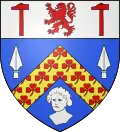
Arms of Saint-Sylvain |
The arms of Saint-Martin-Sylvain are blazoned : Azure, a chevron Or semy of trefoils between 2 lances and a man's head argent, and on a chief argent a lion between 2 hammers gules. |
Population
| Year | Pop. | ±% p.a. |
|---|---|---|
| 1968 | 191 | — |
| 1975 | 157 | −2.76% |
| 1982 | 178 | +1.81% |
| 1990 | 223 | +2.86% |
| 1999 | 212 | −0.56% |
| 2007 | 178 | −2.16% |
| 2012 | 183 | +0.56% |
| 2017 | 179 | −0.44% |
| Source: INSEE[3] | ||
Places of interest
- The church of St.Silvain, dating from the thirteenth century.
- A sixteenth-century stone cross.
- The thirteenth-century château of Anglesqueville-les-Mur.
References
- Liste des maires du département de la Seine-Maritime, 10 August 2020
- "Populations légales 2017". INSEE. Retrieved 6 January 2020.
- Population en historique depuis 1968, INSEE
| Wikimedia Commons has media related to Saint-Sylvain (Seine-Maritime). |
| Authority control |
|
|---|
This article is issued from Wikipedia. The text is licensed under Creative Commons - Attribution - Sharealike. Additional terms may apply for the media files.