Saint-Ouen-du-Breuil
Saint-Ouen-du-Breuil is a commune in the Seine-Maritime department in the Normandy region in northern France.
Saint-Ouen-du-Breuil | |
|---|---|
.svg.png.webp) Coat of arms | |
Location of Saint-Ouen-du-Breuil 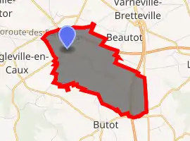
| |
 Saint-Ouen-du-Breuil  Saint-Ouen-du-Breuil | |
| Coordinates: 49°38′22″N 1°00′37″E | |
| Country | France |
| Region | Normandy |
| Department | Seine-Maritime |
| Arrondissement | Dieppe |
| Canton | Luneray |
| Intercommunality | CC Terroir de Caux |
| Government | |
| • Mayor (2020–2026) | Nicole Dehais |
| Area 1 | 6.3 km2 (2.4 sq mi) |
| Population (2017-01-01)[1] | 778 |
| • Density | 120/km2 (320/sq mi) |
| Time zone | UTC+01:00 (CET) |
| • Summer (DST) | UTC+02:00 (CEST) |
| INSEE/Postal code | 76628 /76890 |
| Elevation | 154–182 m (505–597 ft) (avg. 175 m or 574 ft) |
| 1 French Land Register data, which excludes lakes, ponds, glaciers > 1 km2 (0.386 sq mi or 247 acres) and river estuaries. | |
Geography
A farming village situated in the Pays de Caux, some 16 miles (26 km) north of Rouen at the junction of the D22 and the D253 roads. Both the A29 and the A151 autoroutes pass through the commune's territory.
Population
| Year | Pop. | ±% p.a. |
|---|---|---|
| 1968 | 362 | — |
| 1975 | 377 | +0.58% |
| 1982 | 582 | +6.40% |
| 1990 | 645 | +1.29% |
| 1999 | 685 | +0.67% |
| 2007 | 749 | +1.12% |
| 2012 | 772 | +0.61% |
| 2017 | 778 | +0.15% |
| Source: INSEE[2] | ||
Places of interest
- The church of St. Ouen, dating from the thirteenth century.
References
- "Populations légales 2017". INSEE. Retrieved 6 January 2020.
- Population en historique depuis 1968, INSEE
| Wikimedia Commons has media related to Saint-Ouen-du-Breuil. |
| Authority control |
|---|
This article is issued from Wikipedia. The text is licensed under Creative Commons - Attribution - Sharealike. Additional terms may apply for the media files.
