Saint-Saire
Saint-Saire is a commune in the Seine-Maritime department in the Normandy region in north-western France.
Saint-Saire | |
|---|---|
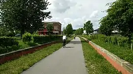 The green cycleway through the old railway station | |
Location of Saint-Saire 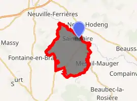
| |
 Saint-Saire  Saint-Saire | |
| Coordinates: 49°41′41″N 1°29′37″E | |
| Country | France |
| Region | Normandy |
| Department | Seine-Maritime |
| Arrondissement | Dieppe |
| Canton | Neufchâtel-en-Bray |
| Intercommunality | CC Bray-Eawy |
| Government | |
| • Mayor (2020–2026) | Maryse Duval[1] |
| Area 1 | 13.32 km2 (5.14 sq mi) |
| Population (2017-01-01)[2] | 611 |
| • Density | 46/km2 (120/sq mi) |
| Time zone | UTC+01:00 (CET) |
| • Summer (DST) | UTC+02:00 (CEST) |
| INSEE/Postal code | 76649 /76270 |
| Elevation | 88–193 m (289–633 ft) (avg. 104 m or 341 ft) |
| 1 French Land Register data, which excludes lakes, ponds, glaciers > 1 km2 (0.386 sq mi or 247 acres) and river estuaries. | |
Geography
A village of farming and associated light industry situated by the banks of the Béthune River in the Pays de Bray, some 30 miles (48 km) southeast of Dieppe at the junction of the D7, D19 and the D1314 roads.
Population
| Year | Pop. | ±% p.a. |
|---|---|---|
| 1968 | 514 | — |
| 1975 | 433 | −2.42% |
| 1982 | 374 | −2.07% |
| 1990 | 418 | +1.40% |
| 1999 | 477 | +1.48% |
| 2007 | 582 | +2.52% |
| 2012 | 635 | +1.76% |
| 2017 | 611 | −0.77% |
| Source: INSEE[3] | ||
Places of interest
- The church of St. Saire, dating from the thirteenth century.
People
- Henri de Boulainvilliers, French write and historian, was born here.
References
- "Répertoire national des élus: les maires". data.gouv.fr, Plateforme ouverte des données publiques françaises (in French). 2 December 2020. Retrieved 7 December 2020.
- "Populations légales 2017". INSEE. Retrieved 6 January 2020.
- Population en historique depuis 1968, INSEE
| Wikimedia Commons has media related to Saint-Saire. |
| Authority control |
|---|
This article is issued from Wikipedia. The text is licensed under Creative Commons - Attribution - Sharealike. Additional terms may apply for the media files.