Saint-Martin-aux-Arbres
Saint-Martin-aux-Arbres is a commune in the Seine-Maritime department in the Normandy region in northern France.
Saint-Martin-aux-Arbres | |
|---|---|
 Coat of arms | |
Location of Saint-Martin-aux-Arbres 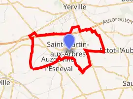
| |
 Saint-Martin-aux-Arbres  Saint-Martin-aux-Arbres | |
| Coordinates: 49°39′00″N 0°53′39″E | |
| Country | France |
| Region | Normandy |
| Department | Seine-Maritime |
| Arrondissement | Rouen |
| Canton | Yvetot |
| Intercommunality | CC Plateau de Caux-Doudeville-Yerville |
| Government | |
| • Mayor (2020–2026) | Olivier Ricoeur[1] |
| Area 1 | 5.14 km2 (1.98 sq mi) |
| Population (2017-01-01)[2] | 324 |
| • Density | 63/km2 (160/sq mi) |
| Time zone | UTC+01:00 (CET) |
| • Summer (DST) | UTC+02:00 (CEST) |
| INSEE/Postal code | 76611 /76760 |
| Elevation | 147–175 m (482–574 ft) (avg. 170 m or 560 ft) |
| 1 French Land Register data, which excludes lakes, ponds, glaciers > 1 km2 (0.386 sq mi or 247 acres) and river estuaries. | |
Geography
A farming village situated in the Pays de Caux, some 22 miles (35 km) northwest of Rouen at the junction of the D467, D88 and the D142 roads. The A29 autoroute forms most of the northern border of the commune.
Heraldry
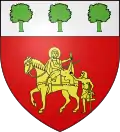
Arms of Saint-Martin-aux-Arbres |
The arms of Saint-Martin-aux-Arbres are blazoned : Gules, St. Martin on horseback dividing his cloak with an upright beggar to sinister Or, and on a chief argent, 3 trees vert. |
Population
| Year | Pop. | ±% p.a. |
|---|---|---|
| 1968 | 243 | — |
| 1975 | 230 | −0.78% |
| 1982 | 218 | −0.76% |
| 1990 | 287 | +3.50% |
| 1999 | 283 | −0.16% |
| 2007 | 289 | +0.26% |
| 2012 | 318 | +1.93% |
| 2017 | 324 | +0.37% |
| Source: INSEE[3] | ||
Places of interest
- The church of St. Martin, dating from the thirteenth century.
References
- Liste des maires du département de la Seine-Maritime, 10 August 2020
- "Populations légales 2017". INSEE. Retrieved 6 January 2020.
- Population en historique depuis 1968, INSEE
| Wikimedia Commons has media related to Saint-Martin-aux-Arbres. |
| Authority control |
|---|
This article is issued from Wikipedia. The text is licensed under Creative Commons - Attribution - Sharealike. Additional terms may apply for the media files.