Saint-Pierre-de-Varengeville
Saint-Martin-de-Varengeville is a commune in the Seine-Maritime department in the Normandy region in northern France.
Saint-Martin-de-Varengeville | |
|---|---|
Location of Saint-Martin-de-Varengeville 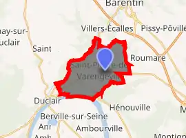
| |
 Saint-Martin-de-Varengeville  Saint-Martin-de-Varengeville | |
| Coordinates: 49°30′08″N 0°56′01″E | |
| Country | France |
| Region | Normandy |
| Department | Seine-Maritime |
| Arrondissement | Rouen |
| Canton | Barentin |
| Intercommunality | Métropole Rouen Normandie |
| Government | |
| • Mayor (2020–2026) | Jean-Michel Mauger |
| Area 1 | 13.18 km2 (5.09 sq mi) |
| Population (2017-01-01)[1] | 2,338 |
| • Density | 180/km2 (460/sq mi) |
| Time zone | UTC+01:00 (CET) |
| • Summer (DST) | UTC+02:00 (CEST) |
| INSEE/Postal code | 76636 /76480 |
| Elevation | 1–132 m (3.3–433.1 ft) (avg. 128 m or 420 ft) |
| 1 French Land Register data, which excludes lakes, ponds, glaciers > 1 km2 (0.386 sq mi or 247 acres) and river estuaries. | |
Geography
A small town of forestry, farming and a little light industry situated by the banks of the Seine, some 7 miles (11 km) northwest of Rouen at the junction of the D90, D43 and the D86 roads.
Population
| Year | Pop. | ±% p.a. |
|---|---|---|
| 1968 | 1,450 | — |
| 1975 | 1,613 | +1.53% |
| 1982 | 1,853 | +2.00% |
| 1990 | 2,143 | +1.83% |
| 1999 | 2,277 | +0.68% |
| 2007 | 2,251 | −0.14% |
| 2012 | 2,195 | −0.50% |
| 2017 | 2,338 | +1.27% |
| Source: INSEE[2] | ||
The church of St. Martin, dating from the nineteenth century.
- The chapel of St. Gilles, dating from the seventeenth century.
- The nineteenth-century chateau Le Breton.
- The seventeenth-century stone cross.
- The chapel of St. Anne.
- Traces of an ancient castle.
References
- "Populations légales 2017". INSEE. Retrieved 6 January 2020.
- Population en historique depuis 1968, INSEE
External links
| Wikimedia Commons has media related to Saint-Pierre-de-Varengeville. |
- Website about Saint-Pierre-de-Varengeville (in French)
| Authority control |
|
|---|
This article is issued from Wikipedia. The text is licensed under Creative Commons - Attribution - Sharealike. Additional terms may apply for the media files.