Auzouville-l'Esneval
Auzouville-l’Esneval is a commune in the Seine-Maritime department in the Normandy region in northern France.
Auzouville-l’Esneval | |
|---|---|
 Coat of arms | |
Location of Auzouville-l’Esneval 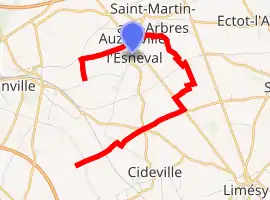
| |
 Auzouville-l’Esneval  Auzouville-l’Esneval | |
| Coordinates: 49°38′33″N 0°53′12″E | |
| Country | France |
| Region | Normandy |
| Department | Seine-Maritime |
| Arrondissement | Rouen |
| Canton | Yvetot |
| Intercommunality | CC Plateau Caux-Doudeville-Yerville |
| Government | |
| • Mayor (2014-2020) | Julien Lachèvre |
| Area 1 | 5.66 km2 (2.19 sq mi) |
| Population (2017-01-01)[1] | 358 |
| • Density | 63/km2 (160/sq mi) |
| Time zone | UTC+01:00 (CET) |
| • Summer (DST) | UTC+02:00 (CEST) |
| INSEE/Postal code | 76045 /76760 |
| Elevation | 129–173 m (423–568 ft) (avg. 165 m or 541 ft) |
| 1 French Land Register data, which excludes lakes, ponds, glaciers > 1 km2 (0.386 sq mi or 247 acres) and river estuaries. | |
Geography
A farming village situated in the Pays de Caux, some 23 miles (37 km) northwest of Rouen at the junction of the D86 and the D263 roads.
Heraldry
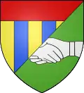
Arms of Auzouville-l’Esneval |
The arms of Auzouville-l’Esneval are blazoned : Per bend sinister 1: paly Or and azure, a chief gules; 2: Vert, a 'foi' argent.' (a 'foi' is two hands fesswise clasped in friendship. |
Population
| Year | 1962 | 1968 | 1975 | 1982 | 1990 | 1999 | 2006 | 2014 |
|---|---|---|---|---|---|---|---|---|
| Population | 155 | 190 | 183 | 260 | 298 | 354 | 337 | 363 |
| From the year 1962 on: No double counting—residents of multiple communes (e.g. students and military personnel) are counted only once. | ||||||||
Places of interest
- The church of St. Etienne, dating from the sixteenth century.
- The church of Notre-Dame, dating from the nineteenth century.
References
- "Populations légales 2017". INSEE. Retrieved 6 January 2020.
| Wikimedia Commons has media related to Auzouville-l'Esneval. |
| Authority control |
|---|
This article is issued from Wikipedia. The text is licensed under Creative Commons - Attribution - Sharealike. Additional terms may apply for the media files.