National Register of Historic Places listings in Bell County, Kentucky
This is a list of the National Register of Historic Places listings in Bell County, Kentucky.
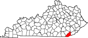
Location of Bell County in Kentucky
It is intended to be a complete list of the properties on the National Register of Historic Places in Bell County, Kentucky, United States. The locations of National Register properties for which the latitude and longitude coordinates are included below, may be seen in a map.[1]
There are 9 properties listed on the National Register in the county.
- This National Park Service list is complete through NPS recent listings posted February 5, 2021.[2]
Current listings
| [3] | Name on the Register | Image | Date listed[4] | Location | City or town | Description |
|---|---|---|---|---|---|---|
| 1 | American Association, Limited, Office Building | 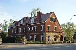 American Association, Limited, Office Building |
December 29, 1978 (#78001299) |
2215 Cumberland Ave. 36°36′24″N 83°43′05″W |
Middlesboro | |
| 2 | Brooks House | 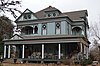 Brooks House |
December 23, 2009 (#09001137) |
210 Arthur Heights 36°36′35″N 83°43′01″W |
Middlesboro | |
| 3 | Cumberland Gap Historic District |  Cumberland Gap Historic District |
May 28, 1980 (#80000366) |
East of Middlesboro 36°36′14″N 83°40′28″W |
Middlesboro | Extends into Claiborne County, Tennessee and Lee County, Virginia |
| 4 | Cumberland Gap National Historical Park |  Cumberland Gap National Historical Park |
October 15, 1966 (#66000353) |
East of Middlesboro along Kentucky-Virginia state line 36°36′14″N 83°40′28″W |
Middlesboro | Extends into Harlan County, Claiborne County, Tennessee and Lee County, Virginia |
| 5 | Hensley Settlement | 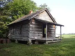 Hensley Settlement |
January 8, 1980 (#80000367) |
Cumberland Gap National Historical Park 36°40′10″N 83°31′42″W |
Cubage | |
| 6 | Middlesboro Downtown Commercial District | 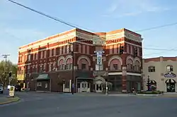 Middlesboro Downtown Commercial District |
January 10, 1983 (#83002554) |
Roughly bounded by Cumberland Ave., 19th, 20th Sts., and Edgewood Rd. 36°36′30″N 83°42′50″W |
Middlesboro | |
| 7 | Middlesboro Jewish Cemetery | August 2, 2017 (#100001419) |
100 Hebrew Cemetery Rd. 36°35′55″N 83°43′14″W |
Middlesboro | ||
| 8 | Mt. Moriah Baptist Church |  Mt. Moriah Baptist Church |
August 8, 1985 (#85001747) |
314 N. Main St. 36°36′38″N 83°42′46″W |
Middlesboro | |
| 9 | Pineville Courthouse Square Historic District |  Pineville Courthouse Square Historic District |
July 19, 1990 (#90001019) |
Along Kentucky, Pine, Virginia, and Walnut Sts. 36°45′41″N 83°41′44″W |
Pineville | Includes the Bell County Courthouse and several commercial buildings[5] |
| 10 | St. Mary's Episcopal Church |  St. Mary's Episcopal Church |
November 15, 1984 (#84000341) |
131 Edgewood Rd. 36°36′32″N 83°43′00″W |
Middlesboro |
See also
| Wikimedia Commons has media related to National Register of Historic Places in Bell County, Kentucky. |
References
- The latitude and longitude information provided in this table was derived originally from the National Register Information System, which has been found to be fairly accurate for about 99% of listings. Some locations in this table may have been corrected to current GPS standards.
- "National Register of Historic Places: Weekly List Actions". National Park Service, United States Department of the Interior. Retrieved on February 5, 2021.
- Numbers represent an alphabetical ordering by significant words. Various colorings, defined here, differentiate National Historic Landmarks and historic districts from other NRHP buildings, structures, sites or objects.
- The eight-digit number below each date is the number assigned to each location in the National Register Information System database, which can be viewed by clicking the number.
- https://npgallery.nps.gov/NRHP/GetAsset/NRHP/90001019_text
| Topics | |
|---|---|
| Lists by state |
|
| Lists by insular areas | |
| Lists by associated state | |
| Other areas | |
| Related | |
| |
Municipalities and communities of Bell County, Kentucky, United States | ||
|---|---|---|
| Cities | Location of Bell County, Kentucky | |
| Unincorporated communities |
| |
| Ghost towns | ||
| Footnotes | ‡This populated place also has portions in an adjacent county or counties | |
| ||
This article is issued from Wikipedia. The text is licensed under Creative Commons - Attribution - Sharealike. Additional terms may apply for the media files.