National Register of Historic Places listings in Nelson County, Kentucky
This is a list of the National Register of Historic Places listings in Nelson County, Kentucky.
Location of Nelson County in Kentucky
This is intended to be a complete list of the properties and districts on the National Register of Historic Places in Nelson County, Kentucky, United States. The locations of National Register properties and districts for which the latitude and longitude coordinates are included below, may be seen in a Google map.[1]
There are 41 properties and districts listed on the National Register in the county.
- This National Park Service list is complete through NPS recent listings posted January 29, 2021.[2]
Current listings
| [3] | Name on the Register | Image | Date listed[4] | Location | City or town | Description |
|---|---|---|---|---|---|---|
| 1 | Archeological Site 15 Ne 3 | September 27, 1979 (#79001027) |
11 miles (18 km) north of Bardstown along the road to Lenore[5] 37°55′55″N 85°30′21″W |
Lenore | ||
| 2 | Baldwin's Tourist Court Residence-Office | 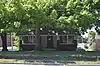 Baldwin's Tourist Court Residence-Office |
November 10, 2011 (#11000797) |
321 W. Stephen Foster Ave. 37°48′36″N 85°28′20″W |
Bardstown | |
| 3 | Bardstown Historic District | 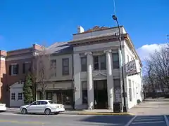 Bardstown Historic District |
February 17, 1983 (#83002837) |
Roughly bounded by 1st, 3rd (U.S. Routes 31E/150), and 5th Sts., Muir Ave., and railroad track; also generally bounded by 1st St., 5th St., Muir Ave., Beall Ave., Maiden's Alley, Cherry Alley, and Mulberry Alley 37°48′40″N 85°27′57″W |
Bardstown | Second set of boundaries represents a boundary increase of November 10, 2010 |
| 4 | Beechwold | 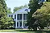 Beechwold |
November 29, 1984 (#84000355) |
500 E. Stephen Foster Ave. (U.S. Routes 62/150) 37°48′34″N 85°27′19″W |
Bardstown | |
| 5 | Bloomfield Historic District | 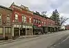 Bloomfield Historic District |
March 18, 1991 (#91000234) |
Central Bloomfield, including parts of Hill, Main, Perry, and Depot Sts. and Fairfield, Springfield, and Taylorsville Roads 37°54′43″N 85°19′09″W |
Bloomfield | |
| 6 | Bruntwood |  Bruntwood |
September 9, 1975 (#75000814) |
714 N. 3rd St. (U.S. Routes 31E/150) 37°49′15″N 85°27′51″W |
Bardstown | |
| 7 | Cobblestone Path | 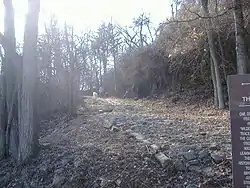 Cobblestone Path |
November 16, 1989 (#89002018) |
Eastern end of Flaget Ave., northeastern to Broadway 37°48′36″N 85°27′46″W |
Bardstown | |
| 8 | Confederate Monument of Bardstown | Confederate Monument of Bardstown |
July 17, 1997 (#97000674) |
North Bardstown Cemetery, 0.3 miles south of the junction of U.S. Routes 31E/150 and KY-245 37°49′28″N 85°27′42″W |
Bardstown | |
| 9 | Coombs-Duncan-Brown Farmhouse | August 5, 2010 (#10000525) |
2985 Chaplin-Taylorsville Rd. 37°56′11″N 85°16′53″W |
Bloomfield | ||
| 10 | Cottage Grove Historic District | 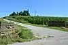 Cottage Grove Historic District |
April 18, 1991 (#91000390) |
1015 Old Bloomfield Pike 37°49′06″N 85°27′07″W |
Bardstown | |
| 11 | Culpeper | May 26, 1988 (#88000674) |
Northern side of Springfield Rd./U.S. Route 150 37°47′59″N 85°26′23″W |
Bardstown | ||
| 12 | Henry Duncan House | December 6, 1990 (#90001843) |
Taylorsville Rd. north of Maple Grove Cemetery 37°55′06″N 85°19′01″W |
Bloomfield | ||
| 13 | Edgewood | 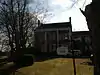 Edgewood |
July 30, 1975 (#75000815) |
310 S. 5th St. 37°48′21″N 85°28′17″W |
Bardstown | |
| 14 | Frankfort and Cincinnati Model 55 Rail Car | October 8, 1998 (#97001344) |
136 S. Main St. 37°39′22″N 85°35′34″W |
New Haven | ||
| 15 | Howard Brothers' Store | October 16, 1986 (#86002861) |
General Delivery 37°34′21″N 85°35′32″W |
Howardstown | ||
| 16 | Ben Johnson House | 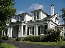 Ben Johnson House |
July 16, 1979 (#79001026) |
1003 N. 3rd St. (U.S. 31E/150) 37°49′42″N 85°27′38″W |
Bardstown | |
| 17 | Silvester Johnson House and Business | 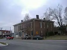 Silvester Johnson House and Business |
April 12, 2002 (#02000345) |
151-153 N. Main St. 37°39′31″N 85°35′36″W |
New Haven | |
| 18 | John S. Kelley House | 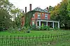 John S. Kelley House |
March 6, 1992 (#91001103) |
306 S. 5th St. 37°48′24″N 85°28′18″W |
Bardstown | |
| 19 | Kurtz Restaurant and Bardstown-Parkview Motel-Office | 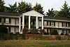 Kurtz Restaurant and Bardstown-Parkview Motel-Office |
November 15, 2011 (#11000798) |
418 E. Stephen Foster Ave. 37°48′32″N 85°27′26″W |
Bardstown | |
| 20 | L & N Steam Locomotive No. 152 | 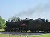 L & N Steam Locomotive No. 152 |
December 30, 1974 (#74000883) |
Junction of Depot and 1st Sts. 37°39′25″N 85°35′31″W |
New Haven | |
| 21 | Louisville and Nashville Combine Car Number 665 | 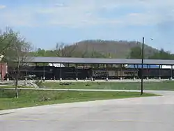 Louisville and Nashville Combine Car Number 665 |
November 19, 1997 (#97001343) |
136 S. Main St. 37°39′25″N 85°35′33″W |
New Haven | |
| 22 | Mattingly House | January 8, 1987 (#87000201) |
Off U.S. Route 150 37°48′27″N 85°25′27″W |
Bardstown | ||
| 23 | Newell B. McClaskey House | 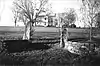 Newell B. McClaskey House |
March 24, 2000 (#00000269) |
1795 KY 1066 37°55′24″N 85°16′16″W |
Bloomfield | |
| 24 | MT. BRODERICK Pullman Lounge-Obs-Sleeping Car | November 18, 1997 (#97001345) |
136 S. Main St. 37°39′22″N 85°35′34″W |
New Haven | ||
| 25 | My Old Kentucky Home | 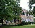 My Old Kentucky Home |
March 11, 1971 (#71000354) |
U.S. Route 150, Stephen Foster Ave. 37°48′25″N 85°27′24″W |
Bardstown | |
| 26 | Nelson County Jail | 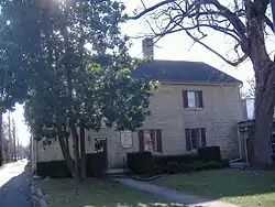 Nelson County Jail |
January 8, 1987 (#87000178) |
111 W. Stephen Foster St. 37°48′32″N 85°28′05″W |
Bardstown | |
| 27 | New Sherwood Hotel |  New Sherwood Hotel |
March 26, 1992 (#92000291) |
138 S. Main St. 37°39′26″N 85°35′37″W |
New Haven | |
| 28 | Old Kentucky Home Motel | 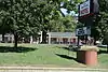 Old Kentucky Home Motel |
November 10, 2011 (#11000799) |
414 W. Stephen Foster Ave. 37°48′40″N 85°28′28″W |
Bardstown | |
| 29 | Old L & N Station | 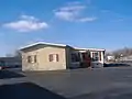 Old L & N Station |
July 12, 1990 (#87002613) |
602 N. 3rd St. (U.S. 31E/150) 37°49′02″N 85°27′53″W |
Bardstown | |
| 30 | Old Talbott Tavern |  Old Talbott Tavern |
October 30, 1973 (#73000822) |
Court Sq. 37°48′32″N 85°28′03″W |
Bardstown | |
| 31 | St. Joseph Cathedral and College Complex | 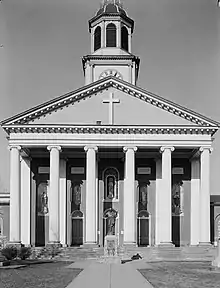 St. Joseph Cathedral and College Complex |
June 3, 1976 (#76000930) |
W. Stephen Foster Ave. 37°48′39″N 85°28′15″W |
Bardstown | |
| 32 | St. Joseph Proto Cathedral | 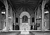 St. Joseph Proto Cathedral |
January 9, 1974 (#74000897) |
W. Stephen Foster Ave. 37°48′39″N 85°28′17″W |
Bardstown | |
| 33 | St. Thomas Roman Catholic Church and Howard-Flaget House | .jpg.webp) St. Thomas Roman Catholic Church and Howard-Flaget House |
July 12, 1976 (#76000931) |
3 miles south of Bardstown off U.S. Route 31E 37°46′00″N 85°29′01″W |
Bardstown | |
| 34 | T. W. Samuels Distillery Historic District | November 1, 1988 (#88002047) |
Junction of KY 523 and Corman Railroad tracks 37°54′00″N 85°33′31″W |
Deatsville | ||
| 35 | Sisters of Charity of Nazareth Historic District | March 15, 1984 (#84001425) |
North of Bardstown off U.S. Route 31E/150 37°50′59″N 85°28′22″W |
Bardstown | ||
| 36 | Spalding Hall, St. Joseph's College | 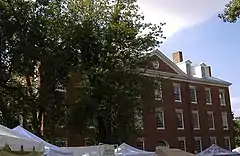 Spalding Hall, St. Joseph's College |
May 7, 1973 (#73000823) |
N. 5th St. 37°48′41″N 85°28′16″W |
Bardstown | |
| 37 | Stone House on Buffalo Creek | August 18, 1983 (#83002838) |
Off KY 245 37°50′29″N 85°31′11″W |
Bardstown | ||
| 38 | John Stone House | July 12, 1984 (#84001885) |
U.S. Route 62 37°54′11″N 85°18′45″W |
Bloomfield | ||
| 39 | Walnut Groves Farm |  Walnut Groves Farm |
April 1, 1980 (#80001662) |
North of Bloomfield on KY 55; also 801 Taylorsville Rd. 37°55′24″N 85°19′15″W |
Bloomfield | Taylorsville Road address represents a boundary increase |
| 40 | Wickland | 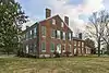 Wickland |
February 16, 1973 (#73000824) |
0.5 miles east of Bardstown on U.S. Route 62 37°48′47″N 85°27′12″W |
Bardstown | |
| 41 | Wilson Motel | November 10, 2011 (#11000800) |
530 N. 3rd St. 37°49′01″N 85°27′54″W |
Bardstown |
See also
| Wikimedia Commons has media related to National Register of Historic Places in Nelson County, Kentucky. |
References
- The latitude and longitude information provided in this table was derived originally from the National Register Information System, which has been found to be fairly accurate for about 99% of listings. Some locations in this table may have been corrected to current GPS standards.
- "National Register of Historic Places: Weekly List Actions". National Park Service, United States Department of the Interior. Retrieved on January 29, 2021.
- Numbers represent an alphabetical ordering by significant words. Various colorings, defined here, differentiate National Historic Landmarks and historic districts from other NRHP buildings, structures, sites or objects.
- The eight-digit number below each date is the number assigned to each location in the National Register Information System database, which can be viewed by clicking the number.
- Funkhouser, W.D., and W.S. Webb. "Archaeological Survey of Kentucky". University of Kentucky Reports in Anthropology 7.5 (1950): 318.
| Topics | |
|---|---|
| Lists by state |
|
| Lists by insular areas | |
| Lists by associated state | |
| Other areas | |
| Related | |
| |
Municipalities and communities of Nelson County, Kentucky, United States | ||
|---|---|---|
| Cities | Location of Nelson County, Kentucky | |
| CDPs | ||
| Other unincorporated communities | ||
| ||
This article is issued from Wikipedia. The text is licensed under Creative Commons - Attribution - Sharealike. Additional terms may apply for the media files.