National Register of Historic Places listings in Jessamine County, Kentucky
This is a list of the National Register of Historic Places listings in Jessamine County, Kentucky.
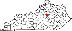
Location of Jessamine County in Kentucky
This is intended to be a complete list of the properties and districts on the National Register of Historic Places in Jessamine County, Kentucky, United States. The locations of National Register properties and districts for which the latitude and longitude coordinates are included below, may be seen in a map.[1]
There are 73 properties and districts listed on the National Register in the county, of which one is a National Historic Landmark.
- This National Park Service list is complete through NPS recent listings posted February 5, 2021.[2]
Current listings
| [3] | Name on the Register | Image | Date listed[4] | Location | City or town | Description |
|---|---|---|---|---|---|---|
| 1 | Asbury College Administration Building | 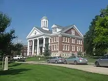 Asbury College Administration Building |
July 6, 1985 (#85001532) |
Kentucky Route 29 37°51′49″N 84°39′43″W |
Wilmore | Part of the Asbury College campus; renamed the "Hager Administration Building" in 1993.[5] |
| 2 | Barkley House | July 5, 1984 (#84001590) |
U.S. Route 68 37°54′22″N 84°37′01″W |
Nicholasville | ||
| 3 | Isaac Barkley House | July 5, 1984 (#84001594) |
Kentucky Route 169 37°54′52″N 84°36′32″W |
Nicholasville | ||
| 4 | Bethel Academy Site (15JS80) | March 15, 1984 (#84001597) |
Atop bluffs above the Kentucky River at High Bridge, 4 miles from Wilmore[6] 37°49′20″N 84°42′18″W |
Wilmore | Site of the first Methodist school west of the Appalachians[6] | |
| 5 | Bicknell House | July 5, 1984 (#84001600) |
Kentucky Route 29 37°51′13″N 84°40′21″W |
Wilmore | ||
| 6 | Brick House on Shun Pike | 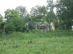 Brick House on Shun Pike |
July 5, 1984 (#84001601) |
Off Kentucky Route 1268 37°50′33″N 84°37′03″W |
Nicholasville | |
| 7 | J.S. Bronaugh House | July 5, 1984 (#84001603) |
103 N. 2nd St. 37°52′53″N 84°34′28″W |
Nicholasville | ||
| 8 | George I. Brown House | 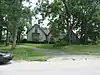 George I. Brown House |
December 2, 1977 (#77000632) |
206 Linden Lane 37°52′22″N 84°34′43″W |
Nicholasville | |
| 9 | George and Betty Bryan House | 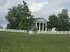 George and Betty Bryan House |
July 5, 1984 (#84001606) |
U.S. Route 68 37°53′23″N 84°39′17″W |
Nicholasville | |
| 10 | Bryant House | July 6, 1985 (#85001541) |
U.S. Route 27 37°55′32″N 84°33′43″W |
Nicholasville | ||
| 11 | Burrier House | July 13, 1984 (#84001607) |
North of Keene 37°57′57″N 84°37′04″W |
Keene | ||
| 12 | Butler's Tavern | 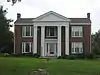 Butler's Tavern |
July 5, 1984 (#84001608) |
U.S. Route 27 37°50′41″N 84°35′16″W |
Nicholasville | |
| 13 | Camp Nelson | 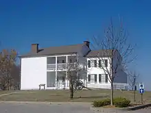 Camp Nelson |
March 15, 2001 (#00000861) |
U.S. Route 27 37°47′16″N 84°35′53″W |
Nicholasville | |
| 14 | Camp Nelson National Cemetery | 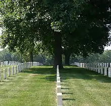 Camp Nelson National Cemetery |
September 3, 1998 (#98001134) |
6890 Danville Rd. 37°47′07″N 84°35′59″W |
Nicholasville | |
| 15 | Canewood Farm | April 29, 1999 (#99000494) |
8080 Harrodsburg Rd. 37°53′43″N 84°38′15″W |
Nicholasville | ||
| 16 | Chaumiere des Prairies | 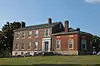 Chaumiere des Prairies |
September 25, 1975 (#75000780) |
North of Nicholasville off U.S. Route 68 37°56′37″N 84°35′04″W |
Nicholasville | |
| 17 | Joseph Chrisman House | July 5, 1984 (#84001618) |
U.S. Route 27 37°54′49″N 84°33′12″W |
Nicholasville | ||
| 18 | Confederate Memorial in Nicholasville | 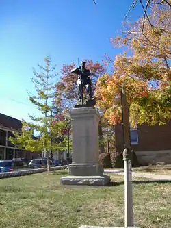 Confederate Memorial in Nicholasville |
July 17, 1997 (#97000686) |
Courthouse lawn, junction of U.S. Route 27 and Kentucky Route 29 37°52′51″N 84°34′24″W |
Nicholasville | |
| 19 | Joseph Crockett House | February 11, 2011 (#83004587) |
Kentucky Route 169 at Union Mills[7] |
Nicholasville | Early Stone Buildings of Central Kentucky Thematic Resource | |
| 20 | Curd House |  Curd House |
July 13, 1984 (#84001621) |
Kentucky Route 29 37°49′55″N 84°42′04″W |
Wilmore | |
| 21 | J.W. Duncan House | July 5, 1984 (#84001622) |
Kentucky Route 169 37°54′00″N 84°34′49″W |
Nicholasville | ||
| 22 | Nathaniel Dunn House | March 7, 1979 (#79001015) |
North of Nicholasville off U.S. Route 68 37°57′06″N 84°35′32″W |
Nicholasville | ||
| 23 | East Main Street Historic District | 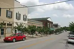 East Main Street Historic District |
August 5, 1994 (#94000840) |
Roughly E. Main St. from S. Walnut St. to Rice St. 37°51′32″N 84°39′35″W |
Wilmore | |
| 24 | Ebenezer Presbyterian Church | 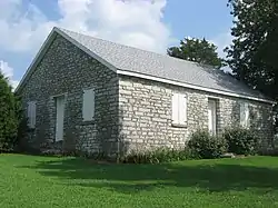 Ebenezer Presbyterian Church |
June 23, 1983 (#83002797) |
Off Kentucky Route 1267 37°55′49″N 84°41′04″W |
Keene | |
| 25 | Federal House on Hickman Creek | July 6, 1985 (#85001542) |
West of Logana 37°52′17″N 84°29′57″W |
Logana | ||
| 26 | First Vineyard | September 29, 2015 (#15000656) |
5800 Sugar Creek Pike 37°44′37″N 84°33′52″W |
Nicholasville | ||
| 27 | Fort Bramlette | June 13, 1975 (#75000781) |
Off Fort Bramlette Road, south of Nicholasville[8] 37°45′56″N 84°35′28″W |
Nicholasville | ||
| 28 | A. Grubb House | July 5, 1984 (#84001626) |
Kentucky Route 169 37°52′16″N 84°26′17″W |
Spears | ||
| 29 | Hoover House | 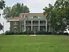 Hoover House |
July 5, 1984 (#84001629) |
U.S. Route 27 37°51′47″N 84°34′55″W |
Nicholasville | |
| 30 | Hughes House | July 5, 1984 (#84001632) |
Kentucky Route 169 37°57′26″N 84°40′22″W |
Keene | ||
| 31 | John Hunter House | July 6, 1985 (#85001540) |
South of Logana 37°50′32″N 84°29′23″W |
Logana | ||
| 32 | Ephriam January House | 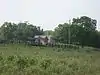 Ephriam January House |
June 23, 1983 (#83002798) |
Address Restricted |
Keene | |
| 33 | Keene Springs Hotel | July 5, 1984 (#84001636) |
Kentucky Route 1267 37°56′37″N 84°37′38″W |
Keene | ||
| 34 | Kenyon Avenue Historic District | 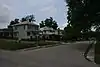 Kenyon Avenue Historic District |
August 5, 1994 (#94000841) |
401, 403, 405, 406, 407, and 408 Kenyon Ave. 37°51′52″N 84°39′48″W |
Wilmore | |
| 35 | Grant Knight House | July 5, 1984 (#84001639) |
Kentucky Route 169 37°55′10″N 84°36′40″W |
Nicholasville | ||
| 36 | John Lancaster House | June 23, 1983 (#83002799) |
Kentucky Route 169 37°57′12″N 84°39′09″W |
Keene | ||
| 37 | Lexington and Main Historic District | 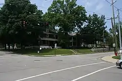 Lexington and Main Historic District |
August 5, 1994 (#94000842) |
100, 101, 102, 103, and 105 N. Lexington Ave. and 101 E. Main St. 37°51′41″N 84°39′43″W |
Wilmore | |
| 38 | Locust Grove Stock Farm | July 5, 1984 (#84001642) |
North of Keene 37°57′59″N 84°37′28″W |
Keene | ||
| 39 | Log House on Shun Pike | 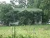 Log House on Shun Pike |
July 5, 1984 (#84001645) |
Off Kentucky Route 1268 37°50′45″N 84°37′03″W |
Nicholasville | |
| 40 | William C. Lowry House | July 5, 1984 (#84001647) |
Off Kentucky Route 169 37°55′53″N 84°36′37″W |
Nicholasville | ||
| 41 | Marshall-Bryan House | 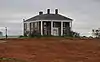 Marshall-Bryan House |
July 5, 1984 (#84001653) |
U.S. Route 27 37°56′55″N 84°32′22″W |
Nicholasville | |
| 42 | James G. Martin House | July 5, 1984 (#84001654) |
Tates Creek Rd. 37°54′38″N 84°27′51″W |
Nicholasville | ||
| 43 | Lewis Y. Martin House | February 7, 2008 (#08000009) |
6975 Tates Creek Pk. 37°54′37″N 84°27′24″W |
Nicholasville | ||
| 44 | McClure-Shelby House | November 20, 1978 (#78001372) |
5 miles (8 km) east of Nicholasville on Kentucky Route 169 37°53′15″N 84°28′49″W |
Nicholasville | ||
| 45 | McConnell-Woodson-Philips House | 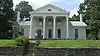 McConnell-Woodson-Philips House |
July 5, 1984 (#84001657) |
303 S. Main St. 37°52′38″N 84°34′29″W |
Nicholasville | |
| 46 | Morrison-Kenyon Library | 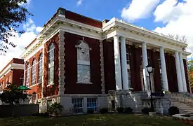 Morrison-Kenyon Library |
July 6, 1985 (#85001539) |
Kentucky Route 29 37°51′48″N 84°39′46″W |
Wilmore | Part of the Asbury College campus; now a student union.[5] |
| 47 | Mt. Pleasant Baptist Church | July 5, 1984 (#84001659) |
North of Keene 37°56′50″N 84°37′47″W |
Keene | ||
| 48 | Nave-Brown House | 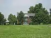 Nave-Brown House |
July 5, 1984 (#84001663) |
Kentucky Route 29 37°53′16″N 84°36′06″W |
Nicholasville | |
| 49 | Davis Newman House | July 5, 1984 (#84001669) |
West of Spears 37°52′20″N 84°26′37″W |
Spears | ||
| 50 | Nicholasville Historic District | 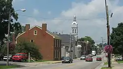 Nicholasville Historic District |
July 19, 1984 (#84001674) |
Court Row, Maple and Main Sts. 37°52′51″N 84°34′26″W |
Nicholasville | |
| 51 | North Lexington Avenue Historic District | 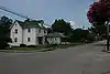 North Lexington Avenue Historic District |
August 5, 1994 (#94000843) |
Roughly N. Lexington Ave. from College Ave. to Banta Ln. 37°52′00″N 84°39′29″W |
Wilmore | |
| 52 | George O'Neal House | July 6, 1985 (#85001538) |
Off U.S. Route 68 37°56′43″N 84°36′34″W |
Nicholasville | ||
| 53 | James O'Neal House | July 6, 1985 (#85001537) |
Off Kentucky Route 169 37°56′02″N 84°36′28″W |
Nicholasville | ||
| 54 | Payne-Saunders House | 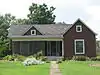 Payne-Saunders House |
July 25, 1996 (#96000799) |
503 N. Central Ave. 37°53′02″N 84°34′08″W |
Nicholasville | |
| 55 | Pleasant Grove | July 5, 1984 (#84001678) |
North of Keene 37°57′19″N 84°37′44″W |
Keene | ||
| 56 | Providence Church | .jpg.webp) Providence Church |
July 5, 1984 (#84001682) |
U.S. Route 27 37°57′28″N 84°32′15″W |
Nicholasville | |
| 57 | Roberts Chapel | 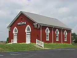 Roberts Chapel |
July 5, 1984 (#84001686) |
U.S. Route 27 37°49′07″N 84°35′47″W |
Nicholasville | |
| 58 | Sandy Bluff |  Sandy Bluff |
July 13, 1984 (#84001689) |
Off Kentucky Route 1268 37°51′05″N 84°36′26″W |
Nicholasville | |
| 59 | Scott House | June 23, 1983 (#83002800) |
U.S. Route 27 37°49′03″N 84°36′11″W |
Little Hickman | ||
| 60 | John Harvey Scott House |  John Harvey Scott House |
July 13, 1984 (#84001692) |
Off U.S. Route 27 37°49′14″N 84°35′02″W |
Nicholasville | |
| 61 | Shady Grove | July 6, 1985 (#85001536) |
Off U.S. Route 27 37°57′07″N 84°33′23″W |
Nicholasville | ||
| 62 | Shanklin House | July 6, 1985 (#85001535) |
Kentucky Route 169 37°54′55″N 84°35′33″W |
Nicholasville | ||
| 63 | Robert Steele House | June 23, 1983 (#83002801) |
Troy Rd. 37°54′N 84°41′W |
Keene | ||
| 64 | Stone House on Brooklyn Hill | June 23, 1983 (#83002802) |
Off U.S. Route 68 37°52′08″N 84°42′10″W |
Wilmore | ||
| 65 | Stone House on West Hickman | .jpg.webp) Stone House on West Hickman |
June 23, 1983 (#83002803) |
Kentucky Route 1980 37°56′23″N 84°30′33″W |
Nicholasville | |
| 66 | Sunnyside Farm House | 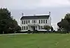 Sunnyside Farm House |
July 5, 1984 (#84001695) |
U.S. Route 27 37°57′34″N 84°32′10″W |
Nicholasville | |
| 67 | Ridge Taylor Farm | July 6, 1985 (#85001534) |
Off Kentucky Route 595 37°48′56″N 84°28′45″W |
Nicholasville | ||
| 68 | Thornwood | July 13, 1984 (#84001697) |
Baker Lane 37°55′16″N 84°34′39″W |
Nicholasville | ||
| 69 | Venable-Todhunter Houses | .jpg.webp) Venable-Todhunter Houses |
July 5, 1984 (#84001781) |
Tates Creek Rd. 37°56′22″N 84°28′52″W |
Nicholasville | |
| 70 | Waveland | July 5, 1984 (#84001587) |
2299 Brannon Rd. 37°57′57″N 84°33′45″W |
Nicholasville | Formerly listed as Craig Ashurst House.[9] | |
| 71 | Woodland | _%E2%80%94_Jessamine_County%252C_Kentucky.jpg.webp) Woodland |
July 5, 1984 (#84001783) |
U.S. Route 27 37°56′57″N 84°36′07″W |
Nicholasville | |
| 72 | Young House | 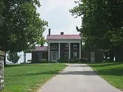 Young House |
July 13, 1984 (#84001787) |
Kentucky Route 29 37°52′58″N 84°38′31″W |
Nicholasville | |
| 73 | A.M. Young House | July 6, 1985 (#85001533) |
West of Ash Grove Pike 37°56′21″N 84°29′38″W |
Nicholasville |
See also
| Wikimedia Commons has media related to National Register of Historic Places in Jessamine County, Kentucky. |
References
- The latitude and longitude information provided in this table was derived originally from the National Register Information System, which has been found to be fairly accurate for about 99% of listings. Some locations in this table may have been corrected to current GPS standards.
- "National Register of Historic Places: Weekly List Actions". National Park Service, United States Department of the Interior. Retrieved on February 5, 2021.
- Numbers represent an alphabetical ordering by significant words. Various colorings, defined here, differentiate National Historic Landmarks and historic districts from other NRHP buildings, structures, sites or objects.
- The eight-digit number below each date is the number assigned to each location in the National Register Information System database, which can be viewed by clicking the number.
- Asbury College Facilities, Asbury College, 2009. Accessed 2009-07-24.
- Thacker, Joseph A., Jr. Asbury College: Vision and Miracle. Nappanee: Evangel, 1900, 19.
- JS182 Joseph Crockett House, Kentucky Digital Library, University of Kentucky, 2016. Accessed 2019-01-14.
- Location derived from its GNIS feature record; the NRIS lists the site as "Address Restricted"
- Kimmerer, Thomas W. (April 13, 2016), National Register of Historic Places Registration Form: Waveland (New Name and Boundary Increase) (PDF), retrieved March 24, 2017.
| Topics | |
|---|---|
| Lists by state |
|
| Lists by insular areas | |
| Lists by associated state | |
| Other areas | |
| Related | |
| |
Municipalities and communities of Jessamine County, Kentucky, United States | ||
|---|---|---|
| Cities | Location of Jessamine County, Kentucky | |
| CDP | ||
| Other unincorporated communities | ||
| Ghost towns | ||
| ||
This article is issued from Wikipedia. The text is licensed under Creative Commons - Attribution - Sharealike. Additional terms may apply for the media files.