National Register of Historic Places listings in Metcalfe County, Kentucky
This is a list of the National Register of Historic Places listings in Metcalfe County, Kentucky.

Location of Metcalfe County in Kentucky
It is intended to be a complete list of the properties on the National Register of Historic Places in Metcalfe County, Kentucky, United States. The locations of National Register properties for which the latitude and longitude coordinates are included below, may be seen in a map.[1]
There are 5 properties listed on the National Register in the county.
- This National Park Service list is complete through NPS recent listings posted January 29, 2021.[2]
Current listings
| [3] | Name on the Register | Image | Date listed[4] | Location | City or town | Description |
|---|---|---|---|---|---|---|
| 1 | The Bell House | 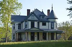 The Bell House |
February 12, 2016 (#16000012) |
7310 Columbia Rd. 36°59′53″N 85°30′57″W |
Edmonton | Free Classic frame house in rural area |
| 2 | Metcalfe County Jail | 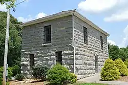 Metcalfe County Jail |
August 4, 2004 (#04000791) |
Corner of East 36°58′50″N 85°36′40″W |
Edmonton | |
| 3 | Metcalfe County Kentucky Courthouse | 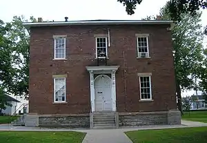 Metcalfe County Kentucky Courthouse |
March 24, 2000 (#00000271) |
Public Square 36°58′45″N 85°36′41″W |
Edmonton | |
| 4 | Stockton-Ray House | 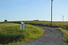 Stockton-Ray House |
April 13, 1992 (#92000289) |
Off the junction of U.S. Route 68/Kentucky Route 80 and Cumberland Parkway 36°59′40″N 85°39′15″W |
Edmonton | |
| 5 | Sulphur Well Historic District | 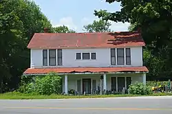 Sulphur Well Historic District |
August 14, 1998 (#98000932) |
Roughly bounded by Wister Wallace Rd., the southern fork of the Little Barren River, Mitchell-Edwards Rd., and Kentucky Route 70 37°06′03″N 85°38′04″W |
Sulphur Well |
See also
| Wikimedia Commons has media related to National Register of Historic Places in Metcalfe County, Kentucky. |
References
- The latitude and longitude information provided in this table was derived originally from the National Register Information System, which has been found to be fairly accurate for about 99% of listings. Some locations in this table may have been corrected to current GPS standards.
- "National Register of Historic Places: Weekly List Actions". National Park Service, United States Department of the Interior. Retrieved on January 29, 2021.
- Numbers represent an alphabetical ordering by significant words. Various colorings, defined here, differentiate National Historic Landmarks and historic districts from other NRHP buildings, structures, sites or objects.
- The eight-digit number below each date is the number assigned to each location in the National Register Information System database, which can be viewed by clicking the number.
| Topics | |
|---|---|
| Lists by state |
|
| Lists by insular areas | |
| Lists by associated state | |
| Other areas | |
| Related | |
| |
Municipalities and communities of Metcalfe County, Kentucky, United States | ||
|---|---|---|
| City | Location of Metcalfe County, Kentucky | |
| CDP | ||
| Other unincorporated communities | ||
| Ghost towns | ||
| ||
This article is issued from Wikipedia. The text is licensed under Creative Commons - Attribution - Sharealike. Additional terms may apply for the media files.