National Register of Historic Places listings in Pike County, Kentucky
This is a list of the National Register of Historic Places listings in Pike County, Kentucky.

Location of Pike County in Kentucky
This is intended to be a complete list of the properties and districts on the National Register of Historic Places in Pike County, Kentucky, United States. The locations of National Register properties and districts for which the latitude and longitude coordinates are included below, may be seen in a map.[1]
There are 16 properties and districts listed on the National Register in the county.
- This National Park Service list is complete through NPS recent listings posted February 5, 2021.[2]
Current listings
| [3] | Name on the Register | Image | Date listed[4] | Location | City or town | Description |
|---|---|---|---|---|---|---|
| 1 | Chesapeake and Ohio Passenger Depot |  Chesapeake and Ohio Passenger Depot |
April 23, 1987 (#87000618) |
Hellier Ave. 37°28′45″N 82°31′10″W |
Pikeville | |
| 2 | College Street Historic District |  College Street Historic District |
September 20, 1984 (#84001913) |
Roughly College St. from Elm St. to Huffman Ave. 37°28′37″N 82°31′14″W |
Pikeville | |
| 3 | Commercial Historic District |  Commercial Historic District |
September 20, 1984 (#84001916) |
Main St. and Division Ave. 37°28′45″N 82°31′04″W |
Pikeville | |
| 4 | Elkhorn City Elementary and High School |  Elkhorn City Elementary and High School |
March 17, 2015 (#15000085) |
551 Russell St. 37°18′01″N 82°21′18″W |
Elkhorn City | |
| 5 | Fordson Coal Company Buildings |  Fordson Coal Company Buildings |
September 6, 2002 (#02000917) |
1355, 1377, and 1393 Pond Creek Rd. 37°35′05″N 82°16′15″W |
Stone | |
| 6 | R. T. Greer and Company |  R. T. Greer and Company |
September 20, 1984 (#84001918) |
Auxier St. 37°28′56″N 82°31′08″W |
Pikeville | |
| 7 | Hatfield-McCoy Feud Historic District |  Hatfield-McCoy Feud Historic District |
August 5, 1976 (#76000939) |
Multiple locations in Pike County 37°28′45″N 82°31′03″W |
Pikeville | |
| 8 | Huffman Avenue Historic District |  Huffman Avenue Historic District |
April 26, 1984 (#84001927) |
Huffman Ave. and Main St. 37°28′40″N 82°31′06″W |
Pikeville | |
| 9 | Odd Fellows Building |  Odd Fellows Building |
April 26, 1984 (#84001929) |
333 2nd St. 37°28′50″N 82°31′05″W |
Pikeville | |
| 10 | Pauley Bridge | 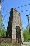 Pauley Bridge |
March 26, 1992 (#92000290) |
Across the Levisa Fork of the Big Sandy River from Pauley to U.S. Routes 23/460 37°29′34″N 82°32′08″W |
Pikeville | |
| 11 | Pikeville College Academy Building |  Pikeville College Academy Building |
February 16, 1973 (#73000828) |
College St. 37°28′33″N 82°31′18″W |
Pikeville | |
| 12 | Scott Avenue Historic District | 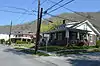 Scott Avenue Historic District |
September 20, 1984 (#84001931) |
Scott Ave., 6th and 7th Sts. 37°29′06″N 82°31′14″W |
Pikeville | |
| 13 | Stone Historic District |  Stone Historic District |
December 4, 2003 (#03001226) |
Portions of Pond Creek and Hensley Hollow Rds., Baptist, Irick, Eastern and May Sts., and Trout Town Ln. 37°35′16″N 82°16′14″W |
Stone | |
| 14 | Third Street Historic District | 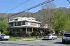 Third Street Historic District |
September 20, 1984 (#84001933) |
3rd St. and Scott Ave. 37°29′00″N 82°31′02″W |
Pikeville | |
| 15 | York House |  York House |
April 26, 1984 (#84001935) |
Main St. 37°28′54″N 82°30′57″W |
Pikeville | |
| 16 | York Mansion |  York Mansion |
April 26, 1984 (#84001937) |
209 Elm St. 37°28′39″N 82°31′22″W |
Pikeville |
See also
| Wikimedia Commons has media related to National Register of Historic Places in Pike County, Kentucky. |
References
- The latitude and longitude information provided in this table was derived originally from the National Register Information System, which has been found to be fairly accurate for about 99% of listings. Some locations in this table may have been corrected to current GPS standards.
- "National Register of Historic Places: Weekly List Actions". National Park Service, United States Department of the Interior. Retrieved on February 5, 2021.
- Numbers represent an alphabetical ordering by significant words. Various colorings, defined here, differentiate National Historic Landmarks and historic districts from other NRHP buildings, structures, sites or objects.
- The eight-digit number below each date is the number assigned to each location in the National Register Information System database, which can be viewed by clicking the number.
| Topics | |
|---|---|
| Lists by state |
|
| Lists by insular areas | |
| Lists by associated state | |
| Other areas | |
| Related | |
| |
Municipalities and communities of Pike County, Kentucky, United States | ||
|---|---|---|
| Cities | Location of Pike County, Kentucky | |
| CDPs | ||
| Other unincorporated communities |
| |
| Ghost towns | ||
| ||
This article is issued from Wikipedia. The text is licensed under Creative Commons - Attribution - Sharealike. Additional terms may apply for the media files.