National Register of Historic Places listings in Boone County, Kentucky
This is a list of the National Register of Historic Places listings in Boone County, Kentucky.

Location of Boone County in Kentucky
This is intended to be a complete list of the properties and districts on the National Register of Historic Places in Boone County, Kentucky, United States. The locations of National Register properties and districts for which the latitude and longitude coordinates are included below, may be seen in a map.[1]
There are 107 properties and districts listed on the National Register in the county.
- This National Park Service list is complete through NPS recent listings posted February 5, 2021.[2]
Current listings
| [3] | Name on the Register | Image | Date listed[4] | Location | City or town | Description |
|---|---|---|---|---|---|---|
| 1 | B. M. Allen House | February 6, 1989 (#88003290) |
11301 Riddles Run Rd. 38°54′52″N 84°48′00″W |
Union | ||
| 2 | Anderson Ferry | 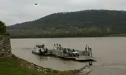 Anderson Ferry |
June 10, 1982 (#82003575) |
39°04′35″N 84°37′28″W |
Constance | |
| 3 | Archaeological Site 15 BE 36 | August 18, 1983 (#83002555) |
Address Restricted |
Union | ||
| 4 | A. J. Aylor House |  A. J. Aylor House |
February 6, 1989 (#88003275) |
2162 Petersburg Rd. 39°04′00″N 84°42′34″W |
Hebron | |
| 5 | Donald Barger House |  Donald Barger House |
February 6, 1989 (#88003259) |
2972 Front St. 39°04′14″N 84°52′02″W |
Petersburg | |
| 6 | Bedinger Site | March 24, 2000 (#00000276) |
Address Restricted |
Walton | ||
| 7 | Belleview Baptist Church | 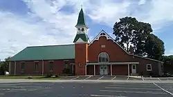 Belleview Baptist Church |
February 6, 1989 (#88003248) |
6658 5th St. 38°59′09″N 84°49′35″W |
Belleview | |
| 8 | Belleview Post Office | June 14, 1990 (#88003250) |
6256 Main St. 38°59′09″N 84°49′35″W |
Belleview | ||
| 9 | Big Bone Lick Archeological District | August 22, 2002 (#00000284) |
Along Big Bone Creek 38°52′58″N 84°44′59″W |
Union | ||
| 10 | Big Bone Lick State Park | 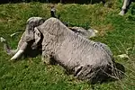 Big Bone Lick State Park |
June 13, 1972 (#72001585) |
Route 1 38°53′10″N 84°45′15″W |
Union | |
| 11 | Big Bone Methodist Church | 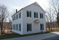 Big Bone Methodist Church |
February 6, 1989 (#88003287) |
3435 Beaver Rd. 38°53′19″N 84°45′04″W |
Union | |
| 12 | Blankenbecker-Riley Farm | December 3, 2002 (#00000907) |
2788 Hathaway Rd. 38°57′11″N 84°42′49″W |
Union | ||
| 13 | Clinton Blankenbeker House | Clinton Blankenbeker House |
February 6, 1989 (#88003302) |
7414 U.S. Route 42 38°59′48″N 84°37′53″W |
Florence | |
| 14 | Nicholas S. and Gertrude E. Blau House | November 25, 2005 (#05001305) |
15 Alta Vista Ave. 38°52′00″N 84°36′48″W |
Walton | ||
| 15 | Boone County Distillery Superintendent's House and Guest House | 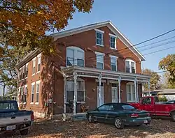 Boone County Distillery Superintendent's House and Guest House |
February 6, 1989 (#88003256) |
3073 Front St. 39°04′10″N 84°52′15″W |
Petersburg | |
| 16 | Botts House | 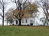 Botts House |
February 6, 1989 (#88003269) |
4752 Petersburg Rd. 39°04′37″N 84°48′13″W |
Burlington | |
| 17 | Burlington Historic District |  Burlington Historic District |
June 19, 1979 (#79000961) |
Kentucky Route 18; also portions of Washington, Gallative, Perlate, Temperate, Garrard, Jefferson, and Ohio Sts., Nicholas Ave., and Union Sq. 39°01′43″N 84°43′27″W |
Burlington | Second set of boundaries represents a boundary increase of August 3, 2005 |
| 18 | B. C. Calvert House | February 6, 1989 (#88003292) |
10246 Lower River Rd. 38°56′26″N 84°50′47″W |
Union | ||
| 19 | Jonathan Carlton House |  Jonathan Carlton House |
November 10, 1982 (#82001551) |
Market St. 39°04′11″N 84°52′03″W |
Petersburg | |
| 20 | Robert Chamber House | August 24, 2000 (#00000906) |
118 Chambers Rd. 38°53′22″N 84°36′34″W |
Walton | ||
| 21 | A. E. Chambers Octagonal Barn | February 7, 1989 (#88003268) |
5009 Petersburg Rd. 39°04′08″N 84°48′51″W |
Petersburg | ||
| 22 | C. Scott Chambers House and Funeral Parlor | August 24, 2000 (#00000911) |
111 N. Main St. 38°52′15″N 84°36′50″W |
Walton | ||
| 23 | Robert Chambers House | October 10, 1975 (#75000733) |
301 E. Bend Rd. 39°01′12″N 84°43′30″W |
Burlington | ||
| 24 | Chandler House | February 6, 1989 (#88003305) |
167 S. Main St. 38°51′19″N 84°36′20″W |
Walton | ||
| 25 | Christian Meeting House |  Christian Meeting House |
February 6, 1989 (#88003262) |
6561 Tanner St. 39°04′07″N 84°52′06″W |
Petersburg | |
| 26 | Clore House |  Clore House |
February 6, 1989 (#88003252) |
6001 Burlington Pike 38°59′37″N 84°49′27″W |
Belleview | |
| 27 | Jonas Clore House | February 6, 1989 (#88003249) |
6256 Main St. 38°59′09″N 84°49′35″W |
Belleview | ||
| 28 | Jonas Clore Log House | August 24, 2000 (#00000910) |
9293 E. Bend Rd. 38°57′53″N 84°48′03″W |
Burlington | ||
| 29 | Code House | November 25, 2005 (#05001306) |
965 Beaver Rd. 38°52′28″N 84°38′59″W |
Walton | ||
| 30 | Capt. N. Collins House District | February 6, 1989 (#88003253) |
6255 Aurora Ferry Rd. 39°03′15″N 84°53′22″W |
Petersburg | ||
| 31 | Allie Corn House | February 6, 1989 (#88003271) |
2807 Graves Rd. 39°04′34″N 84°44′16″W |
Hebron | ||
| 32 | Crisler-Crisler Mounds Site | April 11, 2002 (#02000341) |
Address Restricted |
Hebron | ||
| 33 | Dr. M. J. Crouch House | February 6, 1989 (#88003307) |
2063 Hathaway Rd. 38°56′38″N 84°41′06″W |
Union | ||
| 34 | John Delehunty House |  John Delehunty House |
February 6, 1989 (#88003300) |
212 Main St. 39°00′14″N 84°37′24″W |
Florence | Tudor Revival style house, apparently demolished. |
| 35 | Sam Delph House | February 6, 1989 (#88003270) |
4633 Garrison Creek Rd. 39°05′45″N 84°47′47″W |
Petersburg | ||
| 36 | W. T. Delph House | February 6, 1989 (#88003277) |
6180 Rogers Ln. 39°01′25″N 84°43′11″W |
Burlington | ||
| 37 | Daniel Dew House | 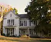 Daniel Dew House |
February 6, 1989 (#88003264) |
2950 3rd St. 39°04′08″N 84°51′53″W |
Petersburg | |
| 38 | Dinsmore House |  Dinsmore House |
March 28, 1979 (#79000962) |
West of Burlington on Kentucky Route 18 39°00′03″N 84°48′49″W |
Burlington | |
| 39 | Early House |  Early House |
February 6, 1989 (#88003297) |
2970 1st St. 39°04′11″N 84°51′59″W |
Petersburg | |
| 40 | East Bend Church | _Photo.jpg.webp) East Bend Church |
February 6, 1989 (#88003291) |
12341 Lower River Rd. 38°55′09″N 84°51′31″W |
Union | |
| 41 | Edwards House | February 7, 1989 (#88003304) |
143 S. Main St. 38°51′23″N 84°36′27″W |
Walton | ||
| 42 | Farmers Bank of Petersburg | 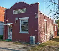 Farmers Bank of Petersburg |
February 6, 1989 (#88003261) |
3010 1st St. 39°04′09″N 84°52′05″W |
Petersburg | |
| 43 | Flick House | February 6, 1989 (#88003251) |
6282 Burlington Pike 38°59′13″N 84°49′38″W |
Belleview | ||
| 44 | Florence Fire Station | 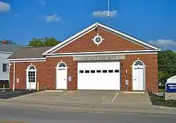 Florence Fire Station |
February 6, 1989 (#88003301) |
Main St. 39°00′03″N 84°37′37″W |
Florence | |
| 45 | Florence Hotel | 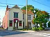 Florence Hotel |
February 6, 1989 (#88003280) |
262 Main St. 39°00′06″N 84°37′37″W |
Florence | |
| 46 | Benjamin Piatt Fowler House | October 29, 1982 (#82001552) |
North of Union on U.S. Route 42 38°57′36″N 84°40′54″W |
Union | ||
| 47 | Benjamin R. Gaines Farm | February 6, 1989 (#88003299) |
3895 Idlewild Rd. 39°03′31″N 84°46′51″W |
Burlington | ||
| 48 | Col. Abner Gaines House | 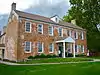 Col. Abner Gaines House |
April 10, 1980 (#80001483) |
North of Walton at 84 Old Lexington Pike 38°53′03″N 84°36′30″W |
Walton | Boundaries increased on February 4, 2010, but details of increase not provided |
| 49 | George-Vest House | 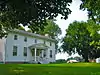 George-Vest House |
August 24, 2000 (#00000913) |
13815 Walton-Verona Rd. 38°50′34″N 84°38′25″W |
Verona | |
| 50 | William Milburn Glore House | 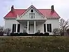 William Milburn Glore House |
December 3, 2002 (#00000904) |
11682 Big Bone-Union Rd. 38°53′56″N 84°44′08″W |
Union | |
| 51 | Virginia Corey Goodridge House |  Virginia Corey Goodridge House |
August 24, 2000 (#00000902) |
259 Main St. 39°00′05″N 84°37′36″W |
Florence | |
| 52 | Gordon's Hall | 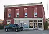 Gordon's Hall |
February 6, 1989 (#88003260) |
6561 Market St. 39°04′09″N 84°52′04″W |
Petersburg | |
| 53 | M. B. Green Site | March 26, 2008 (#08000208) |
Address Restricted |
Petersburg | ||
| 54 | Peter Gregory House | August 24, 2000 (#00000905) |
5063 Beaver Rd. 38°54′06″N 84°48′13″W |
Union | ||
| 55 | Hamilton School | February 6, 1989 (#88003308) |
4837 Beaver Rd. 38°54′04″N 84°47′46″W |
Union | ||
| 56 | Hebron Deposit Bank | 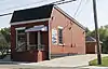 Hebron Deposit Bank |
February 6, 1989 (#88003274) |
1871 Petersburg Rd. 39°03′56″N 84°41′52″W |
Hebron | |
| 57 | Harvey A. Hicks House | February 6, 1989 (#88003281) |
1325 Hicks Pike 38°54′38″N 84°39′43″W |
Walton | ||
| 58 | Samuel Hind House | 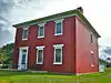 Samuel Hind House |
June 14, 1990 (#88003278) |
417 Stephenson Mill Rd. 38°51′17″N 84°38′04″W |
Walton | |
| 59 | Hopeful Lutheran Church | 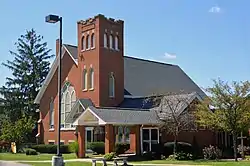 Hopeful Lutheran Church |
February 6, 1989 (#88003279) |
6431 Hopeful Rd. 38°59′59″N 84°39′33″W |
Florence | |
| 60 | Agnes Horton House | 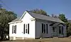 Agnes Horton House |
February 6, 1989 (#88003263) |
2901 2nd St. 39°04′14″N 84°51′48″W |
Petersburg | |
| 61 | Hudson House | 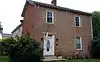 Hudson House |
February 6, 1989 (#88003283) |
12328 Gaines Way 38°52′55″N 84°37′55″W |
Walton | |
| 62 | D. W. Huey House | February 6, 1989 (#88003294) |
7812 East Bend Rd. 38°58′40″N 84°44′20″W |
Burlington | ||
| 63 | Thomas Huey Farm | August 24, 2000 (#00000900) |
10492 Big Bone Rd. 38°55′44″N 84°43′20″W |
Union | ||
| 64 | Hughes House | February 6, 1989 (#88003282) |
771 Chambers Rd. 38°53′38″N 84°38′43″W |
Walton | ||
| 65 | Jenkins-Berkshire House | 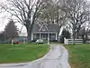 Jenkins-Berkshire House |
August 24, 2000 (#00000908) |
6529 Mill St. 39°03′59″N 84°52′18″W |
Petersburg | |
| 66 | Cave Johnson House | February 6, 1989 (#88003273) |
8368 River Rd. 39°08′23″N 84°44′23″W |
Hebron | ||
| 67 | Kirtley House | February 9, 1989 (#89000013) |
2451 Second Creek Rd. 39°04′44″N 84°49′46″W |
Petersburg | ||
| 68 | Rev. Robert E. Kirtley House | February 6, 1989 (#88003272) |
8545 River Rd. 39°07′52″N 84°44′54″W |
Hebron | ||
| 69 | James William Kite Store | July 30, 2014 (#14000456) |
8800 E. Bend Rd. 38°58′21″N 84°47′23″W |
Burlington | ||
| 70 | Morris Lassing House | 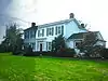 Morris Lassing House |
June 14, 1990 (#88003285) |
10515 U.S. Route 42 38°55′40″N 84°40′37″W |
Union | |
| 71 | Loder House | 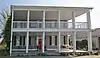 Loder House |
February 6, 1989 (#88003257) |
3028 Front St. 39°04′10″N 84°52′08″W |
Petersburg | |
| 72 | Maplewood | March 24, 2000 (#00000275) |
Address Restricted |
Walton | ||
| 73 | John Clifton and Ann Catherine Mayhugh House | November 25, 2005 (#05001309) |
133 N. Main St. 38°52′20″N 84°36′47″W |
Walton | ||
| 74 | John Clifton Mayhugh House | February 6, 1989 (#88003303) |
113 N. Main St. 38°52′15″N 84°36′50″W |
Walton | ||
| 75 | W. F. and Florence McKim House | November 25, 2005 (#05001310) |
6031 S. Orient St. 39°01′33″N 84°43′17″W |
Burlington | ||
| 76 | Frank S. Milburn Machine Shop | November 25, 2005 (#05001311) |
5844 N. Orient St. 39°02′00″N 84°43′13″W |
Burlington | ||
| 77 | M. Miller House | February 6, 1989 (#88003289) |
3805 Beaver Rd. 38°53′25″N 84°45′56″W |
Union | ||
| 78 | John Moore House | March 29, 1978 (#78001300) |
6 miles (9.6 km) northwest of Francisville 39°06′55″N 84°46′35″W |
Francisville | ||
| 79 | L. C. Norman House | February 6, 1989 (#88003286) |
1966 Mt. Zion Rd. 38°56′46″N 84°40′48″W |
Union | ||
| 80 | Richard Parker House | February 6, 1989 (#88003296) |
4312 Belleview Rd. 39°02′16″N 84°51′50″W |
Petersburg | ||
| 81 | Peters House | 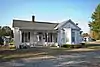 Peters House |
February 6, 1989 (#88003298) |
2973 3rd St. 39°04′06″N 84°51′50″W |
Petersburg | |
| 82 | Piatt's Landing |  Piatt's Landing |
July 18, 1974 (#74000849) |
South of Burlington off Kentucky Route 338 38°54′05″N 84°51′33″W |
Burlington | |
| 83 | Prospect Farm |  Prospect Farm |
February 6, 1989 (#88003265) |
6279 Petersburg Rd. 39°03′47″N 84°51′47″W |
Petersburg | |
| 84 | Rabbit Hash General Store | 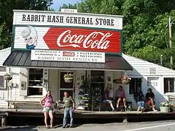 Rabbit Hash General Store |
February 6, 1989 (#88003293) |
10021 Lower River Rd. 38°56′32″N 84°50′46″W |
Rabbit Hash | Severely damaged by fire February 2016[5] |
| 85 | Rabbit Hash Historic District |  Rabbit Hash Historic District |
December 4, 2003 (#03001231) |
10021-10410 Lower River Rd. 38°56′29″N 84°51′02″W |
Rabbit Hash | |
| 86 | Ransom House | February 6, 1989 (#88003284) |
1842 Messmer Rd. 38°48′28″N 84°38′51″W |
Crittenden | ||
| 87 | Reeves Mound | August 3, 1990 (#90001154) |
Address Restricted |
Stringtown | ||
| 88 | Thomas Zane Roberts House and Workshop | February 28, 2012 (#12000042) |
5074 Middle Creek Rd. 38°59′37″N 84°47′21″W |
Burlington | ||
| 89 | Rogers Site | October 31, 1983 (#83003647) |
Address Restricted |
Petersburg | ||
| 90 | Boone Fowler Rogers Barn | August 24, 2000 (#00000901) |
5394 Belleview Rd. 39°01′01″N 84°49′49″W |
Petersburg | ||
| 91 | James Rogers House | 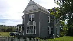 James Rogers House |
February 6, 1989 (#88003295) |
6259 Sycamore St. 38°59′07″N 84°49′30″W |
Belleview | |
| 92 | Henry and Agnes Rolsen House | November 25, 2005 (#05001312) |
3044 Dry Creek Rd. 39°04′24″N 84°38′21″W |
Constance | ||
| 93 | Dr. Gladys Rouse Office and House | 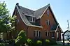 Dr. Gladys Rouse Office and House |
November 25, 2005 (#05001313) |
221 Main St. 39°00′11″N 84°37′26″W |
Florence | |
| 94 | Ryle's Super Market and Oddfellows Building | 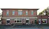 Ryle's Super Market and Oddfellows Building |
February 6, 1989 (#88003258) |
6571 Tanner St. 39°04′08″N 84°52′14″W |
Petersburg | |
| 95 | South Main Street Historic District | March 17, 2005 (#04001249) |
Roughly along Main St. between Edwards and Loreco Sts. 38°51′38″N 84°36′37″W |
Walton | ||
| 96 | Abe Souther House | January 8, 1987 (#87000143) |
Off Kentucky Route 237 39°05′55″N 84°42′27″W |
Francisville | ||
| 97 | J. Q. A. Stephens House | November 25, 2005 (#05001308) |
5572 Rabbit Hash Rd. 38°56′14″N 84°48′13″W |
Union | ||
| 98 | Dr. John E. Stevenson House | August 24, 2000 (#00000912) |
3422 Beaver Rd. 38°53′20″N 84°45′03″W |
Union | ||
| 99 | John Tanner House | January 8, 1987 (#87000207) |
Kentucky Route 20 39°03′54″N 84°51′52″W |
Petersburg | ||
| 100 | George W. Terrill House | 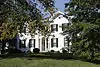 George W. Terrill House |
February 6, 1989 (#88003266) |
6002 Petersburg Rd. 39°03′50″N 84°51′02″W |
Petersburg | |
| 101 | John G. Tomlin House | November 25, 2005 (#05001314) |
109 N. Main St. 38°52′14″N 84°36′50″W |
Walton | ||
| 102 | Ephraim Uitz House | June 14, 1990 (#88003276) |
5208 Bullitssville Rd. 39°02′31″N 84°43′08″W |
Burlington | ||
| 103 | Verona High School | December 3, 2002 (#00000909) |
14923 Walton-Verona Rd. 38°49′09″N 84°39′27″W |
Verona | ||
| 104 | Wallace House | February 6, 1989 (#88003306) |
67 S. Main St. 38°51′41″N 84°36′38″W |
Walton | ||
| 105 | John J. Walton House | February 28, 2012 (#12000041) |
5408 Belleview Rd. 39°00′36″N 84°50′01″W |
Belleview | ||
| 106 | Watts House | January 8, 1987 (#87000208) |
Williams Rd. 39°05′49″N 84°45′03″W |
Bullittsville | ||
| 107 | Wingate-Gaines Farm District | February 7, 1989 (#88003267) |
5225 Whitton Rd. 39°02′54″N 84°49′18″W |
Petersburg |
See also
| Wikimedia Commons has media related to National Register of Historic Places in Boone County, Kentucky. |
References
- The latitude and longitude information provided in this table was derived originally from the National Register Information System, which has been found to be fairly accurate for about 99% of listings. Some locations in this table may have been corrected to current GPS standards.
- "National Register of Historic Places: Weekly List Actions". National Park Service, United States Department of the Interior. Retrieved on February 5, 2021.
- Numbers represent an alphabetical ordering by significant words. Various colorings, defined here, differentiate National Historic Landmarks and historic districts from other NRHP buildings, structures, sites or objects.
- The eight-digit number below each date is the number assigned to each location in the National Register Information System database, which can be viewed by clicking the number.
| Topics | |
|---|---|
| Lists by state |
|
| Lists by insular areas | |
| Lists by associated state | |
| Other areas | |
| Related | |
| |
Municipalities and communities of Boone County, Kentucky, United States | ||
|---|---|---|
| Cities | Location of Boone County, Kentucky | |
| CDPs | ||
| Unincorporated Communities | ||
| Ghost town | ||
| Footnotes | ‡This populated place also has portions in an adjacent county or counties. | |
| ||
This article is issued from Wikipedia. The text is licensed under Creative Commons - Attribution - Sharealike. Additional terms may apply for the media files.