National Register of Historic Places listings in Meade County, Kentucky
This is a list of the National Register of Historic Places listings in Meade County, Kentucky.
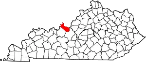
Location of Meade County in Kentucky
This is intended to be a complete list of the properties and districts on the National Register of Historic Places in Meade County, Kentucky, United States. The locations of National Register properties and districts for which the latitude and longitude coordinates are included below, may be seen in a Google map.[1]
There are 13 properties and districts listed on the National Register in the county.
- This National Park Service list is complete through NPS recent listings posted February 5, 2021.[2]
Current listings
| [3] | Name on the Register | Image | Date listed[4] | Location | City or town | Description |
|---|---|---|---|---|---|---|
| 1 | Brandenburg Commercial District | 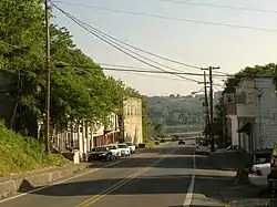 Brandenburg Commercial District |
March 27, 1986 (#86000523) |
Main St. 38°00′11″N 86°10′10″W |
Brandenburg | |
| 2 | Brandenburg Methodist Episcopal Church | 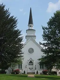 Brandenburg Methodist Episcopal Church |
August 14, 1984 (#84001828) |
215 Broadway 37°59′59″N 86°10′09″W |
Brandenburg | |
| 3 | Clarkson House | May 24, 1983 (#83002825) |
Clarkson Rd. 37°48′48″N 86°06′20″W |
Flaherty | ||
| 4 | Doe Run Creek Historic District | 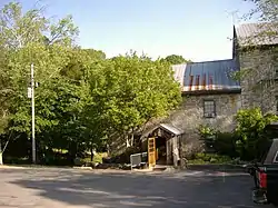 Doe Run Creek Historic District |
December 19, 1978 (#78001386) |
Southeast of Brandenburg off KY 448 37°57′09″N 86°07′34″W |
Brandenburg | |
| 5 | Doe Run Mill | October 6, 1987 (#87002053) |
Kentucky Route 1638 on Doe Run Creek 37°57′35″N 86°07′19″W |
Brandenburg | ||
| 6 | Goff-Baskett House | 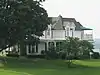 Goff-Baskett House |
August 14, 1984 (#84001832) |
550 Lawrence St. 38°00′21″N 86°10′37″W |
Brandenburg | |
| 7 | Jones-Willis House | 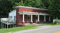 Jones-Willis House |
August 14, 1984 (#84001835) |
321 Main St. 38°00′07″N 86°10′11″W |
Brandenburg | |
| 8 | Meade County Clerk Office-Rankin House | 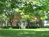 Meade County Clerk Office-Rankin House |
August 14, 1984 (#84001836) |
205 Lafayette St. 38°00′13″N 86°10′00″W |
Brandenburg | |
| 9 | Meade County Jail | 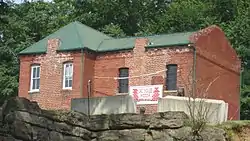 Meade County Jail |
August 14, 1984 (#84001837) |
125 Main St. 38°00′16″N 86°10′05″W |
Brandenburg | |
| 10 | Payneville Petroglyphs (15MD308) | September 8, 1989 (#89001196) |
Address Restricted |
Payneville | ||
| 11 | Richardson House | 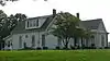 Richardson House |
August 14, 1984 (#84001838) |
547 Lawrence St. 38°00′18″N 86°10′38″W |
Brandenburg | |
| 12 | St. Theresa Roman Catholic Church | November 17, 1977 (#77000635) |
3 miles northwest of Rhodelia on KY 144 38°01′48″N 86°26′20″W |
Rhodelia | ||
| 13 | Edward Yeakel House | 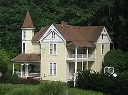 Edward Yeakel House |
August 14, 1984 (#84001839) |
116 Decatur St. 38°00′08″N 86°10′08″W |
Brandenburg |
See also
| Wikimedia Commons has media related to National Register of Historic Places in Meade County, Kentucky. |
References
- The latitude and longitude information provided in this table was derived originally from the National Register Information System, which has been found to be fairly accurate for about 99% of listings. Some locations in this table may have been corrected to current GPS standards.
- "National Register of Historic Places: Weekly List Actions". National Park Service, United States Department of the Interior. Retrieved on February 5, 2021.
- Numbers represent an alphabetical ordering by significant words. Various colorings, defined here, differentiate National Historic Landmarks and historic districts from other NRHP buildings, structures, sites or objects.
- The eight-digit number below each date is the number assigned to each location in the National Register Information System database, which can be viewed by clicking the number.
| Topics | |
|---|---|
| Lists by state |
|
| Lists by insular areas | |
| Lists by associated state | |
| Other areas | |
| Related | |
| |
Municipalities and communities of Meade County, Kentucky, United States | ||
|---|---|---|
| Cities | Location of Meade County, Kentucky | |
| CDPs | ||
| Unincorporated communities | ||
| Footnotes | ‡This populated place also has portions in an adjacent county or counties | |
| ||
This article is issued from Wikipedia. The text is licensed under Creative Commons - Attribution - Sharealike. Additional terms may apply for the media files.