National Register of Historic Places listings in Estill County, Kentucky
This is a list of the National Register of Historic Places listings in Estill County, Kentucky.
Location of Estill County in Kentucky
It is intended to be a complete list of the properties on the National Register of Historic Places in Estill County, Kentucky, United States. The locations of National Register properties for which the latitude and longitude coordinates are included below, may be seen in a map.[1]
There are 8 properties listed on the National Register in the county.
- This National Park Service list is complete through NPS recent listings posted February 5, 2021.[2]
Current listings
| [3] | Name on the Register | Image | Date listed[4] | Location | City or town | Description |
|---|---|---|---|---|---|---|
| 1 | Ashley Petroglyphs (15ES27) | September 8, 1989 (#89001186) |
Address Restricted |
Furnace | ||
| 2 | Cottage Iron Furnace | September 20, 1973 (#73000794) |
7 miles northeast of Irvine in Daniel Boone National Forest 37°45′27″N 83°54′51″W |
Irvine | ||
| 3 | Irvine Grade School | 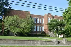 Irvine Grade School |
August 18, 2000 (#00000865) |
228 Broadway 37°41′54″N 83°58′06″W |
Irvine | |
| 4 | Irvine Historic Business District | 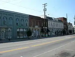 Irvine Historic Business District |
August 2, 2000 (#00000866) |
Roughly the junction of Kentucky Routes 52 and 89 37°41′59″N 83°58′30″W |
Irvine | |
| 5 | Ravenna Motor Vehicle Service Building | 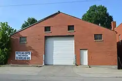 Ravenna Motor Vehicle Service Building |
June 21, 2000 (#00000278) |
512 Main St. 37°41′04″N 83°57′09″W |
Ravenna | |
| 6 | Red River Iron Furnace |  Red River Iron Furnace |
May 17, 1974 (#74000860) |
Kentucky Route 975, in Daniel Boone National Forest 37°43′58″N 83°51′10″W |
Fitchburg | |
| 7 | Riverview Hotel | 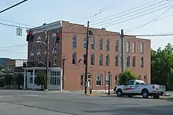 Riverview Hotel |
April 3, 1992 (#92000171) |
Main St. 37°41′58″N 83°58′31″W |
Irvine | |
| 8 | Sparks Indian Rock House Petroglyphs (15ES26) | September 8, 1989 (#89001187) |
Address Restricted |
Lexington |
See also
| Wikimedia Commons has media related to National Register of Historic Places in Estill County, Kentucky. |
References
- The latitude and longitude information provided in this table was derived originally from the National Register Information System, which has been found to be fairly accurate for about 99% of listings. Some locations in this table may have been corrected to current GPS standards.
- "National Register of Historic Places: Weekly List Actions". National Park Service, United States Department of the Interior. Retrieved on February 5, 2021.
- Numbers represent an alphabetical ordering by significant words. Various colorings, defined here, differentiate National Historic Landmarks and historic districts from other NRHP buildings, structures, sites or objects.
- The eight-digit number below each date is the number assigned to each location in the National Register Information System database, which can be viewed by clicking the number.
| Topics | |
|---|---|
| Lists by state |
|
| Lists by insular areas | |
| Lists by associated state | |
| Other areas | |
| Related | |
| |
Municipalities and communities of Estill County, Kentucky, United States | ||
|---|---|---|
| Cities | Location of Estill County, Kentucky | |
| Unincorporated communities | ||
| Ghost town | ||
| ||
This article is issued from Wikipedia. The text is licensed under Creative Commons - Attribution - Sharealike. Additional terms may apply for the media files.