National Register of Historic Places listings in Floyd County, Kentucky
This is a list of the National Register of Historic Places listings in Floyd County, Kentucky.
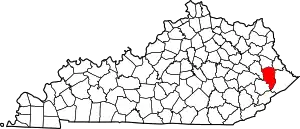
Location of Floyd County in Kentucky
This is intended to be a complete list of the properties and districts on the National Register of Historic Places in Floyd County, Kentucky, United States. The locations of National Register properties and districts for which the latitude and longitude coordinates are included below, may be seen in a map.[1]
There are 15 properties and districts listed on the National Register in the county; 1 of these is a National Historic Landmark. Another property was once listed but has been removed.
- This National Park Service list is complete through NPS recent listings posted January 29, 2021.[2]
Current listings
| [3] | Name on the Register | Image | Date listed[4] | Location | City or town | Description |
|---|---|---|---|---|---|---|
| 1 | G.D. Callihan House |  G.D. Callihan House |
May 18, 1989 (#89000389) |
105 W. Graham St. 37°39′54″N 82°46′22″W |
Prestonsburg | |
| 2 | B.F. Combs House | 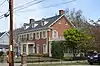 B.F. Combs House |
May 18, 1989 (#89000390) |
41 N. Arnold Ave. 37°40′08″N 82°46′30″W |
Prestonsburg | |
| 3 | Fitzpatrick-Harmon House | May 18, 1989 (#89000388) |
102 E. Court St. 37°40′07″N 82°46′20″W |
Prestonsburg | Old house with a Colonial Revival-style portico added in the 1950s. | |
| 4 | Front Street Historic District | 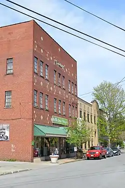 Front Street Historic District |
May 18, 1989 (#89000398) |
Roughly Front St. between W. Court St. and Ford St. 37°40′00″N 82°46′31″W |
Prestonsburg | |
| 5 | Harkins Law Office Building | 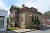 Harkins Law Office Building |
May 18, 1989 (#89000395) |
1 S. Arnold Ave. 37°40′03″N 82°46′26″W |
Prestonsburg | |
| 6 | Joseph D. Harkins House | 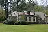 Joseph D. Harkins House |
May 18, 1989 (#89000394) |
204 N. Arnold Ave. 37°40′16″N 82°46′38″W |
Prestonsburg | |
| 7 | Samuel May House | 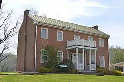 Samuel May House |
April 1, 1980 (#80001526) |
690 N. Lake Dr. 37°41′00″N 82°46′42″W |
Prestonsburg | |
| 8 | May-Fitzpatrick House |  May-Fitzpatrick House |
May 18, 1989 (#89000392) |
39 S. Arnold Ave. 37°40′00″N 82°46′23″W |
Prestonsburg | |
| 9 | May-Latta House | 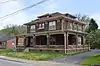 May-Latta House |
May 18, 1989 (#89000393) |
33 N. Arnold Ave. 37°40′06″N 82°46′29″W |
Prestonsburg | |
| 10 | Methodist Episcopal Church, South |  Methodist Episcopal Church, South |
May 18, 1989 (#89000391) |
S. Arnold Ave. between Ford St. and W. Graham St. 37°39′57″N 82°46′23″W |
Prestonsburg | Part of the Methodist Episcopal Church, South |
| 11 | Middle Creek Battlefield | 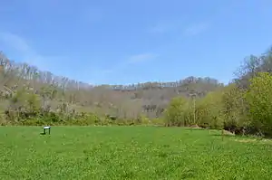 Middle Creek Battlefield |
March 26, 1992 (#91001665) |
3 miles west of Prestonsburg at the junction of Kentucky Routes 114 and 404 37°39′02″N 82°48′50″W |
Prestonsburg | |
| 12 | Town Branch Bridge |  Town Branch Bridge |
May 18, 1989 (#89000396) |
County Road 1334 over Levisa Fork 37°39′51″N 82°46′24″W |
Prestonsburg | Demolished |
| 13 | US Post Office-Prestonsburg | 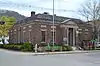 US Post Office-Prestonsburg |
May 18, 1989 (#89000417) |
Central Ave. and E. Court St. 37°40′06″N 82°46′20″W |
Prestonsburg | |
| 14 | West Prestonsburg Bridge | 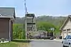 West Prestonsburg Bridge |
May 18, 1989 (#89000397) |
Over Levisa Fork between Prestonsburg and West Prestonsburg 37°40′21″N 82°46′43″W |
Prestonsburg | |
| 15 | Wheelwright Commercial District | 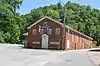 Wheelwright Commercial District |
November 19, 1980 (#80001527) |
Main St. 37°19′58″N 82°43′15″W |
Wheelwright |
Former listing
| [3] | Name on the Register | Image | Date listed | Date removed | Location | City or town | Summary |
|---|---|---|---|---|---|---|---|
| 1 | Garfield Place | December 4, 1974 (#74000871) | February 3, 1988 | 2nd Ave. |
Prestonsburg | aka Garfield Headquarters, John M. Burns House |
See also
| Wikimedia Commons has media related to National Register of Historic Places in Floyd County, Kentucky. |
References
- The latitude and longitude information provided in this table was derived originally from the National Register Information System, which has been found to be fairly accurate for about 99% of listings. Some locations in this table may have been corrected to current GPS standards.
- "National Register of Historic Places: Weekly List Actions". National Park Service, United States Department of the Interior. Retrieved on January 29, 2021.
- Numbers represent an alphabetical ordering by significant words. Various colorings, defined here, differentiate National Historic Landmarks and historic districts from other NRHP buildings, structures, sites or objects.
- The eight-digit number below each date is the number assigned to each location in the National Register Information System database, which can be viewed by clicking the number.
| Topics | |
|---|---|
| Lists by state |
|
| Lists by insular areas | |
| Lists by associated state | |
| Other areas | |
| Related | |
| |
Municipalities and communities of Floyd County, Kentucky, United States | ||
|---|---|---|
| Cities | Location of Floyd County, Kentucky | |
| CDPs | ||
| Other unincorporated communities |
| |
| Footnotes | ‡This populated place also has portions in an adjacent county or counties. | |
| ||
This article is issued from Wikipedia. The text is licensed under Creative Commons - Attribution - Sharealike. Additional terms may apply for the media files.