National Register of Historic Places listings in Simpson County, Kentucky
This is a list of the National Register of Historic Places listings in Simpson County, Kentucky.
Location of Simpson County in Kentucky
This is intended to be a complete list of the properties and districts on the National Register of Historic Places in Simpson County, Kentucky, United States. The locations of National Register properties and districts for which the latitude and longitude coordinates are included below, may be seen in a map.[1]
There are 14 properties and districts listed on the National Register in the county.
- This National Park Service list is complete through NPS recent listings posted February 5, 2021.[2]
Current listings
| [3] | Name on the Register | Image | Date listed[4] | Location | City or town | Description |
|---|---|---|---|---|---|---|
| 1 | The Cedars | .jpg.webp) The Cedars |
January 11, 1996 (#95001516) |
812 E. Cedar St. 36°43′05″N 86°33′28″W |
Franklin | |
| 2 | Duncan House | .jpg.webp) Duncan House |
October 29, 1982 (#82001576) |
301 N. Main St. 36°43′27″N 86°34′39″W |
Franklin | |
| 3 | Franklin Downtown Commercial District | 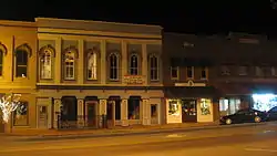 Franklin Downtown Commercial District |
February 17, 1983 (#83002873) |
Roughly Main and College Sts. between Washington and Madison Sts.; also 200 S. Main and 207 S. College Sts. 36°43′22″N 86°34′43″W |
Franklin | Second set of boundaries represents a boundary increase of August 18, 1983 |
| 4 | Franklin Grade and High School | 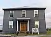 Franklin Grade and High School |
February 3, 2010 (#09001312) |
513 W. Madison St. 36°43′18″N 86°35′02″W |
Franklin | |
| 5 | Goodnight House | 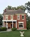 Goodnight House |
August 12, 1977 (#77000647) |
201 S. Main St. 36°43′15″N 86°34′40″W |
Franklin | |
| 6 | Hampton Hall | January 11, 1996 (#95001519) |
6240 Bowling Green Rd. 36°48′46″N 86°33′05″W |
Franklin | ||
| 7 | Hargis House | 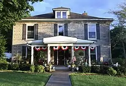 Hargis House |
January 11, 1996 (#95001518) |
300 E. Cedar St. 36°43′17″N 86°34′28″W |
Franklin | |
| 8 | Harristown Historic District | 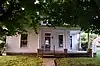 Harristown Historic District |
January 11, 1996 (#95001515) |
Roughly bounded by Walker Ave., Bell St., W. Washington St., and West St. 36°43′35″N 86°35′07″W |
Franklin | |
| 9 | Randolph Gilbert Moore House |  Randolph Gilbert Moore House |
January 11, 1996 (#95001517) |
321 S. College St. 36°43′03″N 86°34′48″W |
Franklin | |
| 10 | Octagon Hall | 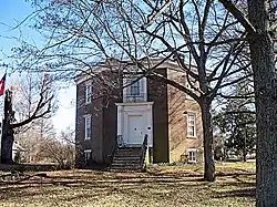 Octagon Hall |
April 10, 1980 (#80001667) |
Northeast of Franklin on U.S. Route 31W 36°48′25″N 86°33′25″W |
Franklin | |
| 11 | Simpson County Courthouse | 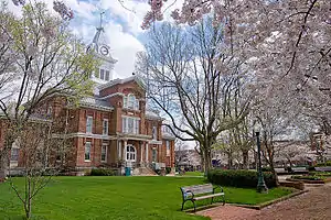 Simpson County Courthouse |
March 18, 1980 (#80001668) |
Kentucky Route 73 36°43′21″N 86°34′42″W |
Franklin | |
| 12 | Sinking Creek Cave System | April 28, 1983 (#83002875) |
Address Restricted |
Franklin | ||
| 13 | Triple Pine Farm | January 11, 1996 (#95001520) |
5945 Bowling Green Rd. 36°48′01″N 86°33′54″W |
Franklin | ||
| 14 | West Cedar Street Historic District | 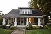 West Cedar Street Historic District |
January 11, 1996 (#95001514) |
Northern and southern sides of W. Cedar St. between N. High and West Sts. 36°43′21″N 86°35′06″W |
Franklin |
See also
| Wikimedia Commons has media related to National Register of Historic Places in Simpson County, Kentucky. |
References
- The latitude and longitude information provided in this table was derived originally from the National Register Information System, which has been found to be fairly accurate for about 99% of listings. Some locations in this table may have been corrected to current GPS standards.
- "National Register of Historic Places: Weekly List Actions". National Park Service, United States Department of the Interior. Retrieved on February 5, 2021.
- Numbers represent an alphabetical ordering by significant words. Various colorings, defined here, differentiate National Historic Landmarks and historic districts from other NRHP buildings, structures, sites or objects.
- The eight-digit number below each date is the number assigned to each location in the National Register Information System database, which can be viewed by clicking the number.
| Topics | |
|---|---|
| Lists by state |
|
| Lists by insular areas | |
| Lists by associated state | |
| Other areas | |
| Related | |
| |
Municipalities and communities of Simpson County, Kentucky, United States | ||
|---|---|---|
| City | Location of Simpson County, Kentucky | |
| Unincorporated communities | ||
| ||
This article is issued from Wikipedia. The text is licensed under Creative Commons - Attribution - Sharealike. Additional terms may apply for the media files.