National Register of Historic Places listings in Clay County, Kentucky
This is a list of the National Register of Historic Places listings in Clay County, Kentucky.
Location of Clay County in Kentucky
It is intended to be a complete list of the properties on the National Register of Historic Places in Clay County, Kentucky, United States. The locations of National Register properties for which the latitude and longitude coordinates are included below, may be seen in a map.[1]
There are 4 properties listed on the National Register in the county. Another property was once listed but has been removed.
- This National Park Service list is complete through NPS recent listings posted February 5, 2021.[2]
Current listings
| [3] | Name on the Register | Image | Date listed[4] | Location | City or town | Description |
|---|---|---|---|---|---|---|
| 1 | Fish Trap Rock Petroglyphs (15CY53) | 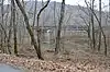 Fish Trap Rock Petroglyphs (15CY53) |
September 8, 1989 (#89001181) |
Western bank of the Red Bird River at the Hal Rogers Parkway crossing[5] 37°10′25″N 83°35′21″W |
Eriline | |
| 2 | Peabody-Fordson Historic District | 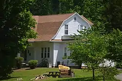 Peabody-Fordson Historic District |
February 1, 2017 (#89002099) |
Kentucky Route 66, south of Big Creek 37°08′20″N 83°35′24″W |
Big Creek | |
| 3 | Red Bird River Shelter Petroglyphs (15CY52) | September 8, 1989 (#89001183) |
Address Restricted |
Manchester | ||
| 4 | Sullen Possum Site | October 6, 1993 (#93000996) |
Address Restricted |
Oneida |
Former listing
| [3] | Name on the Register | Image | Date listed | Date removed | Location | City or town | Summary |
|---|---|---|---|---|---|---|---|
| 1 | Red Bird River Petroglyphs (15CY51) |  Red Bird River Petroglyphs (15CY51) |
September 8, 1989 (#89001182) | December 4, 2003 | Address Restricted |
Manchester |
See also
| Wikimedia Commons has media related to National Register of Historic Places in Clay County, Kentucky. |
References
- The latitude and longitude information provided in this table was derived originally from the National Register Information System, which has been found to be fairly accurate for about 99% of listings. Some locations in this table may have been corrected to current GPS standards.
- "National Register of Historic Places: Weekly List Actions". National Park Service, United States Department of the Interior. Retrieved on February 5, 2021.
- Numbers represent an alphabetical ordering by significant words. Various colorings, defined here, differentiate National Historic Landmarks and historic districts from other NRHP buildings, structures, sites or objects.
- The eight-digit number below each date is the number assigned to each location in the National Register Information System database, which can be viewed by clicking the number.
- Coy, Fred E., et al. Rock Art of Kentucky. Lexington: UP of Kentucky, 2003, 38.
| Topics | |
|---|---|
| Lists by state |
|
| Lists by insular areas | |
| Lists by associated state | |
| Other areas | |
| Related | |
| |
Municipalities and communities of Clay County, Kentucky, United States | ||
|---|---|---|
| City | Location of Clay County, Kentucky | |
| CDP | ||
| Other unincorporated communities | ||
| ||
This article is issued from Wikipedia. The text is licensed under Creative Commons - Attribution - Sharealike. Additional terms may apply for the media files.