National Register of Historic Places listings in Woodford County, Kentucky
This is a list of the National Register of Historic Places listings in Woodford County, Kentucky.

Location of Woodford County in Kentucky
This is intended to be a complete list of the properties and districts on the National Register of Historic Places in Woodford County, Kentucky, United States. The locations of National Register properties and districts for which the latitude and longitude coordinates are included below, may be seen in a map.[1]
There are 85 properties and districts listed on the National Register in the county, of which 1 is a National Historic Landmark.
- This National Park Service list is complete through NPS recent listings posted January 29, 2021.[2]
Current listings
| [3] | Name on the Register | Image | Date listed[4] | Location | City or town | Description |
|---|---|---|---|---|---|---|
| 1 | Airy Mount | November 15, 1978 (#78001417) |
Southwest of Versailles off U.S. Route 62 38°01′38″N 84°46′28″W |
Versailles | ||
| 2 | Alexander Plantation House | 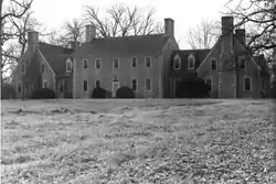 Alexander Plantation House |
June 23, 1983 (#83002891) |
Off Old Frankford Pike 38°08′45″N 84°44′29″W |
Midway | |
| 3 | John Allen House | June 23, 1983 (#83002892) |
Off Kentucky Route 169 37°58′40″N 84°41′00″W |
Keene | ||
| 4 | Archeological Site 15Wd61 | June 2, 1982 (#82004853) |
Address Restricted |
Nonesuch | ||
| 5 | Arnold-Wooldridge House | May 29, 1979 (#79001048) |
South of Versailles 38°00′21″N 84°45′52″W |
Versailles | ||
| 6 | Ayres House | January 27, 1994 (#93001522) |
Southern side of U.S. Route 421, less than 0.3 miles east of Drucker's Rd. 38°10′32″N 84°46′26″W |
Midway | ||
| 7 | Big Sink Rural Historic District | January 27, 1994 (#93001523) |
West of Midway off Interstate 64 38°07′17″N 84°43′17″W |
Versailles | ||
| 8 | Big Spring Church | 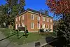 Big Spring Church |
May 6, 1975 (#75000842) |
121 Rose Hill St. 38°03′07″N 84°43′54″W |
Versailles | |
| 9 | Charles Black Farm | February 10, 1989 (#88003347) |
Faywood Rd. 38°06′18″N 84°38′34″W |
Versailles | ||
| 10 | Edward M. Blackburn House | December 5, 1985 (#85003073) |
Spring Station Rd. 38°09′30″N 84°44′02″W |
Midway | ||
| 11 | Lucas Broadhead House | January 27, 1994 (#93001524) |
Southwestern corner of the junction of Midway Pike and Aiken Rd. 38°05′41″N 84°43′20″W |
Versailles | ||
| 12 | Buck Pond | February 10, 1989 (#88003344) |
Paynes Mill Rd. 38°04′00″N 84°41′13″W |
Versailles | ||
| 13 | Bullock Site | March 15, 2005 (#05000145) |
Address Restricted |
Versailles | ||
| 14 | Marquis Calmes Tomb | February 10, 1989 (#88003346) |
Paynes Mill Rd. 38°03′32″N 84°40′28″W |
Versailles | ||
| 15 | Carter House | 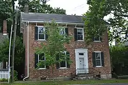 Carter House |
May 2, 1975 (#75000843) |
110 Morgan St. 38°03′05″N 84°43′48″W |
Versailles | |
| 16 | Cleveland House | 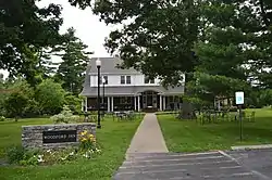 Cleveland House |
April 10, 2007 (#07000287) |
140 Park St. 38°03′16″N 84°43′56″W |
Versailles | |
| 17 | Clifton Country Club | November 7, 1995 (#95001271) |
1190 Buck Run Rd. 38°04′19″N 84°50′17″W |
Versailles | ||
| 18 | Clifton-McCraken Rural Historic District | January 25, 1999 (#98000326) |
Roughly along Clifton and McCraken Pikes, and Steele Rd. 38°04′26″N 84°47′54″W |
Versailles | ||
| 19 | Richard Cole Homestead | January 27, 1994 (#93001525) |
Southern side of Leestown Rd., northwest of Midway 38°09′58″N 84°42′32″W |
Midway | ||
| 20 | Confederate Monument in Versailles | 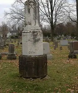 Confederate Monument in Versailles |
July 17, 1997 (#97000662) |
City Cemetery, southeast of the junction of Clifton Rd. and Kentucky Route 33 38°02′57″N 84°43′44″W |
Versailles | |
| 21 | Cooper House | January 27, 1994 (#93001526) |
Northern side of Leestown Rd., 0.9 miles east of the Midway exit from Interstate 64 38°09′05″N 84°39′47″W |
Midway | ||
| 22 | Downtown Versailles Historic District | 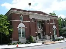 Downtown Versailles Historic District |
September 2, 1975 (#75000844) |
Both sides of Main St. between Rose Hill Ave. and Green St. 38°03′08″N 84°43′50″W |
Versailles | |
| 23 | Joel DuPuy House | 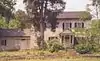 Joel DuPuy House |
June 23, 1983 (#83002893) |
Griers Creek Rd. 38°00′52″N 84°47′49″W |
Tyrone | |
| 24 | Edgewood | May 28, 1976 (#76000960) |
1 mile east of Versailles on U.S. Route 60 38°03′11″N 84°42′15″W |
Versailles | ||
| 25 | Thomas Edwards House and Quarters | June 23, 1983 (#83002894) |
Kentucky Route 1659 38°05′02″N 84°46′44″W |
Tyrone | ||
| 26 | Elkwood | January 27, 1994 (#93001527) |
158 Leestown Pike, W. 38°09′44″N 84°40′56″W |
Midway | ||
| 27 | William Garrett House | 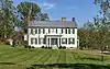 William Garrett House |
June 23, 1983 (#83002895) |
Off Kentucky Route 169 37°59′37″N 84°40′51″W |
Keene | |
| 28 | John Graham House | November 14, 1978 (#78001416) |
Southeast of Midway on Weisenberger Mill Rd. 38°08′20″N 84°40′26″W |
Midway | ||
| 29 | Guyn's Mill Historic District | 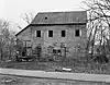 Guyn's Mill Historic District |
August 29, 1983 (#83002897) |
Mundy's Landing and Pauls Mill Rds. 37°54′02″N 84°42′29″W |
Troy | |
| 30 | Robert Guyn, Jr. House | August 25, 1983 (#83002896) |
South of Troy on Kentucky Route 33 37°53′51″N 84°42′20″W |
Troy | ||
| 31 | Ezra Hammon House | August 22, 1983 (#83002898) |
Off Kentucky Route 33 37°56′18″N 84°42′02″W |
Keene | ||
| 32 | A.T. Harris House | February 10, 1989 (#88003345) |
Big Sink Pike 38°06′22″N 84°40′19″W |
Versailles | ||
| 33 | Heartland | May 30, 2019 (#100004004) |
1470 Clifton Rd. 38°03′24″N 84°45′36″W |
Versailles vicinity | ||
| 34 | Hogan Quarters | August 22, 1983 (#83002899) |
Off Kentucky Route 33 38°01′18″N 84°43′18″W |
Versailles | ||
| 35 | Humphries Estate Quarters | June 23, 1983 (#83002900) |
Kentucky Route 1967 38°00′07″N 84°40′06″W |
Versailles | ||
| 36 | Dr. William Jennings House | January 12, 1983 (#83002901) |
South of Pinckard on Kentucky Route 169 37°58′24″N 84°40′49″W |
Pinckard | ||
| 37 | Capt. Jack Jouett House | June 13, 1972 (#72000548) |
5 miles southwest of Versailles off Kentucky Route 1964 37°58′59″N 84°46′31″W |
Versailles | ||
| 38 | Labrot & Graham Distillery |  Labrot & Graham Distillery |
November 7, 1995 (#95001272) |
7855 McCracken Pike 38°06′46″N 84°48′43″W |
Frankfort | |
| 39 | Leavy Tobacco Barn | January 27, 1994 (#93001528) |
Eastern side of Georgetown Rd., 0.8 miles north of the Midway exit from Interstate 64 38°10′04″N 84°39′29″W |
Midway | ||
| 40 | Lexington Extension of the Louisville Southern Railroad | 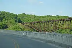 Lexington Extension of the Louisville Southern Railroad |
August 4, 2004 (#04000789) |
Eastern Lawrenceburg to Milner 38°01′56″N 84°49′09″W |
Lawrenceburg | Extends into Anderson County |
| 41 | Thomas Lyne House | November 28, 1980 (#80001691) |
South of Versailles on Smith Lane 37°57′28″N 84°41′06″W |
Versailles | ||
| 42 | Margaret Hall | 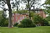 Margaret Hall |
August 3, 1987 (#87001304) |
117 Elm St. 38°03′26″N 84°43′54″W |
Versailles | |
| 43 | Martyrs Monument in Midway | 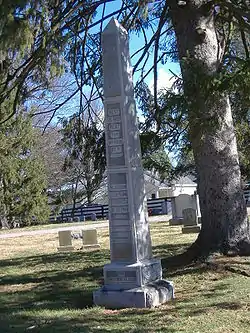 Martyrs Monument in Midway |
July 17, 1997 (#97000663) |
City Cemetery, southwest of the junction of the L&N railroad tracks and U.S. Route 62 38°08′53″N 84°41′40″W |
Midway | |
| 44 | McCrackin Distillery and Mill | June 23, 1983 (#83002903) |
Kentucky Route 1659 38°05′31″N 84°47′17″W |
Tyrone | ||
| 45 | Cyrus McCrackin House and Quarters | August 22, 1983 (#83002902) |
Off Steele Rd. 38°06′22″N 84°46′52″W |
Tyrone | ||
| 46 | Midway Historic District |  Midway Historic District |
November 17, 1978 (#78001415) |
U.S. Route 62 38°08′48″N 84°41′14″W |
Midway | |
| 47 | Miller's House at Mortonsville Mill | June 23, 1983 (#83002904) |
Kentucky Route 1965 37°58′19″N 84°45′25″W |
Salvisa | ||
| 48 | George F. Moore Place | June 23, 1983 (#83002905) |
Off U.S. Route 62 38°06′04″N 84°41′34″W |
Versailles | ||
| 49 | Morgan Street Historic District | 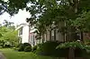 Morgan Street Historic District |
May 8, 1980 (#80001692) |
Morgan St. 38°03′06″N 84°43′37″W |
Versailles | |
| 50 | Moss Side | January 8, 1979 (#79001049) |
Southwest of Versailles on McCowans Ferry Pike 38°01′10″N 84°46′14″W |
Versailles | ||
| 51 | Andrew Muldrow Quarters | June 23, 1983 (#83002907) |
Griers Creek Rd. 38°01′06″N 84°49′11″W |
Tyrone | ||
| 52 | Munday's Landing | September 5, 1975 (#75000845) |
Munday's Landing Rd., south of Versailles on the Kentucky River 37°51′13″N 84°46′16″W |
Versailles | ||
| 53 | Claiborne W. Nuckols Farmstead | January 27, 1994 (#93001529) |
Northern side of U.S. Route 60, 1½ miles north of its junction with Midway Pike 38°05′59″N 84°44′45″W |
Versailles | ||
| 54 | Nugent's Crossroad Historic District | January 27, 1994 (#93001530) |
Junction of Midway and Old Frankfort Pikes 38°07′25″N 84°41′57″W |
Midway | ||
| 55 | Offutt-Cole Tavern | 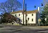 Offutt-Cole Tavern |
November 23, 1977 (#77000664) |
North of Versailles on U.S. Route 62 38°07′24″N 84°42′00″W |
Versailles | |
| 56 | Old Taylor Distillery | 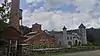 Old Taylor Distillery |
March 13, 2017 (#100000747) |
4445 McCracken Pike 38°08′46″N 84°49′56″W |
Frankfort | |
| 57 | Paul Family Complex | September 23, 1980 (#80001690) |
West of Troy on Paul's Mill Rd. 37°54′18″N 84°42′42″W |
Troy | ||
| 58 | Lewis Payne House | April 29, 1982 (#82002750) |
Lansing Lane 38°07′29″N 84°39′56″W |
Midway | ||
| 59 | Pinkerton Hall | November 20, 1974 (#74000919) |
650 East St. 38°08′46″N 84°40′44″W |
Midway | ||
| 60 | Pisgah Presbyterian Church |  Pisgah Presbyterian Church |
August 22, 1983 (#83002906) |
Off U.S. Route 60 38°03′14″N 84°39′17″W |
Versailles | |
| 61 | Pisgah Rural Historic District | February 10, 1989 (#88003348) |
Area northeast of Versailles roughly bounded by S. Elkhorn Creek, U.S. Route 60, and Big Sink Rd. 38°05′08″N 84°39′40″W |
Versailles | ||
| 62 | Pleasant Lawn | November 15, 1978 (#78001418) |
North of Versailles off U.S. Route 62 at Bonita 38°05′10″N 84°42′29″W |
Versailles | ||
| 63 | Ready-Twyman House | March 7, 2019 (#100003477) |
220 N. Main St. 38°03′19″N 84°43′48″W |
Versailles | ||
| 64 | Redd Road Rural Historic District | February 28, 1991 (#91000153) |
Area largely south and east of the junction of Redd and Frankfort Roads 38°05′30″N 84°37′34″W |
Lexington | Extends into Fayette County | |
| 65 | Robertson Place | June 23, 1983 (#83002908) |
Clifton and Steele Rds. 38°04′38″N 84°48′30″W |
Tyrone | ||
| 66 | Rose Hill Historic District | 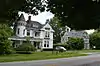 Rose Hill Historic District |
December 17, 1982 (#82001578) |
Rose Hill Ave. 38°03′06″N 84°44′06″W |
Versailles | |
| 67 | Scearce House | April 9, 1987 (#87000602) |
McCracken Pike 38°05′35″N 84°46′30″W |
Versailles | ||
| 68 | Shipp House | June 30, 1983 (#83002909) |
Address Restricted |
Midway | ||
| 69 | South Main Street Historic District | 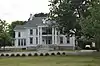 South Main Street Historic District |
July 2, 1987 (#87001106) |
298-321 S. Main St. 38°02′50″N 84°43′47″W |
Versailles | |
| 70 | Stone House at Fisher's Mill | June 23, 1983 (#83002912) |
Off U.S. Route 421 38°10′21″N 84°42′16″W |
Midway | ||
| 71 | Stone House on Beale's Run | June 23, 1983 (#83002910) |
Off Kentucky Route 1685 38°11′02″N 84°44′32″W |
Midway | ||
| 72 | Stone House on Clifton Pike | June 23, 1983 (#83002911) |
Kentucky Route 1964 38°04′11″N 84°47′09″W |
Tyrone | ||
| 73 | Stone House on Steele's Grant | June 23, 1983 (#83002575) |
Off Kentucky Route 1964 38°04′18″N 84°48′58″W |
Tyrone | ||
| 74 | Stone House on Tanner's Creek | June 23, 1983 (#83002913) |
Carpenter Pike 37°58′49″N 84°45′29″W |
Salvisa | ||
| 75 | E.W. Taylor House | January 27, 1994 (#93001531) |
Eastern side of Midway Pike, about ½ mile north of its junction with Old Frankfort Pike 38°07′37″N 84°41′03″W |
Midway | ||
| 76 | Solomon Thomas House | June 23, 1983 (#83002914) |
Craigs Creek Rd. 37°59′21″N 84°48′06″W |
Salvisa | ||
| 77 | W.B. Spring House | June 23, 1983 (#83002915) |
Off U.S. Route 62 38°06′43″N 84°41′40″W |
Versailles | ||
| 78 | Versailles Elementary School | July 10, 2015 (#15000459) |
299 S. Main St. 38°02′51″N 84°43′48″W |
Versailles | Now the Safe Harbor Academy | |
| 79 | Wallace Station Historic District | January 27, 1994 (#93001534) |
Wallace Station, Old Frankfort Pike 38°07′16″N 84°41′39″W |
Midway | ||
| 80 | Samuel Wallace House | January 27, 1994 (#93001532) |
Northern side of Old Frankfort Pike, east of Wallace 38°07′10″N 84°41′16″W |
Midway | ||
| 81 | Wallace-Alford Farmstead | January 27, 1994 (#93001533) |
S.S. Weisenberger (Craig's) Mill Rd. east of Lansing Ln. 38°07′42″N 84°39′21″W |
Midway | ||
| 82 | Weisenberger Mills and Related Buildings | 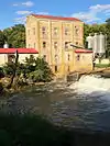 Weisenberger Mills and Related Buildings |
August 16, 1984 (#84001987) |
Off U.S. Route 421 38°07′34″N 84°38′13″W |
Midway | Extends into Scott County |
| 83 | Welcome Hall | October 10, 1975 (#75000846) |
4 miles west of Versailles off Clifton Rd. 38°04′26″N 84°47′47″W |
Versailles | ||
| 84 | Benjamin Wilson House | June 23, 1983 (#83002916) |
Off U.S. Route 62 38°06′43″N 84°41′41″W |
Versailles | ||
| 85 | Wyndehurst | November 15, 1978 (#78001419) |
5 miles (8 km) southwest of Versailles off Kentucky Route 1964 37°59′39″N 84°46′39″W |
Versailles |
Former listing
| [3] | Name on the Register | Image | Date listed | Date removed | Location | City or town | Summary |
|---|---|---|---|---|---|---|---|
| 1 | John Jordan Crittenden Birthplace Cabin | 1972 (#72001554) | 1978 | US 60 |
Versailles | Birthplace of John J. Crittenden. Relocated and restored in 1978. |
See also
| Wikimedia Commons has media related to National Register of Historic Places in Woodford County, Kentucky. |
References
- The latitude and longitude information provided in this table was derived originally from the National Register Information System, which has been found to be fairly accurate for about 99% of listings. Some locations in this table may have been corrected to current GPS standards.
- "National Register of Historic Places: Weekly List Actions". National Park Service, United States Department of the Interior. Retrieved on January 29, 2021.
- Numbers represent an alphabetical ordering by significant words. Various colorings, defined here, differentiate National Historic Landmarks and historic districts from other NRHP buildings, structures, sites or objects.
- The eight-digit number below each date is the number assigned to each location in the National Register Information System database, which can be viewed by clicking the number.
| Topics | |
|---|---|
| Lists by state |
|
| Lists by insular areas | |
| Lists by associated state | |
| Other areas | |
| Related | |
| |
Municipalities and communities of Woodford County, Kentucky, United States | ||
|---|---|---|
| Cities | Location of Woodford County, Kentucky | |
| Unincorporated communities | ||
| Ghost town | ||
| ||
This article is issued from Wikipedia. The text is licensed under Creative Commons - Attribution - Sharealike. Additional terms may apply for the media files.