National Register of Historic Places listings in Nicholas County, Kentucky
This is a list of the National Register of Historic Places listings in Nicholas County, Kentucky.
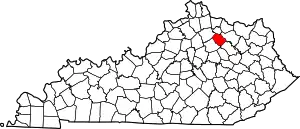
Location of Nicholas County in Kentucky
This is intended to be a complete list of the properties and districts on the National Register of Historic Places in Nicholas County, Kentucky, United States. The locations of National Register properties and districts for which the latitude and longitude coordinates are included below, may be seen in a map.[1]
There are 12 properties and districts listed on the National Register in the county. Another property was once listed but has been removed.
- This National Park Service list is complete through NPS recent listings posted February 5, 2021.[2]
Current listings
| [3] | Name on the Register | Image | Date listed[4] | Location | City or town | Description |
|---|---|---|---|---|---|---|
| 1 | Carlisle Armory | 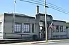 Carlisle Armory |
March 24, 2000 (#00000280) |
378 Main St. 38°18′41″N 84°01′33″W |
Carlisle | |
| 2 | Carlisle Historic District | 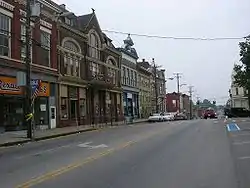 Carlisle Historic District |
October 26, 1989 (#89001599) |
Roughly 2nd, Broadway, North, Archdeacon, Trueman, Chestnut, Walnut, Market, Elm, W. Main, and School Dr. 38°18′52″N 84°01′44″W |
Carlisle | |
| 3 | Carlisle Louisville and Nashville Passenger Depot | 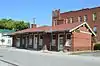 Carlisle Louisville and Nashville Passenger Depot |
May 18, 1979 (#79001028) |
Market and Locust Sts. 38°18′41″N 84°01′43″W |
Carlisle | |
| 4 | Dinsmore House | 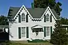 Dinsmore House |
October 11, 1989 (#89001602) |
210 S. Elm St. 38°18′41″N 84°01′56″W |
Carlisle | |
| 5 | Thomas A. Dorsey Farmhouse | 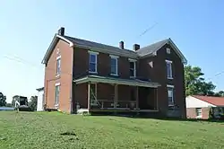 Thomas A. Dorsey Farmhouse |
September 28, 1989 (#89001603) |
416 High St. 38°18′37″N 84°01′22″W |
Carlisle | |
| 6 | James Ellis Stone Tavern | 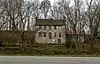 James Ellis Stone Tavern |
March 16, 1976 (#76000932) |
U.S. Route 68 38°23′44″N 84°01′05″W |
Ellisville | |
| 7 | Forest Retreat Farm and Tavern | 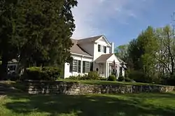 Forest Retreat Farm and Tavern |
October 2, 1973 (#73000825) |
Northwest of Carlisle at the junction of U.S. Route 68 and Kentucky Route 32 38°20′04″N 84°03′39″W |
Carlisle | |
| 8 | Thomas Kennedy House |  Thomas Kennedy House |
September 28, 1989 (#89001601) |
Eastern Ave. at E. Main St. 38°18′43″N 84°01′11″W |
Carlisle | |
| 9 | William Mathers House | 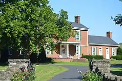 William Mathers House |
October 12, 1989 (#89001600) |
Kentucky Route 36 38°18′43″N 84°02′36″W |
Carlisle | |
| 10 | Erasmus Riggs House | 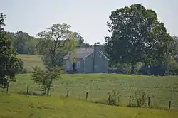 Erasmus Riggs House |
June 23, 1983 (#83002839) |
Off Kentucky Route 13 38°15′55″N 84°03′14″W |
Carlisle | |
| 11 | Stone Barn on Brushy Creek |  Stone Barn on Brushy Creek |
June 23, 1983 (#83002840) |
U.S. Route 68 38°19′51″N 84°04′04″W |
Carlisle | |
| 12 | John Henry Thompson House |  John Henry Thompson House |
June 23, 1983 (#83002841) |
Off Kentucky Routes 32/36 38°20′56″N 84°08′44″W |
Millersburg |
Former listing
| [3] | Name on the Register | Image | Date listed | Date removed | Location | City or town | Summary |
|---|---|---|---|---|---|---|---|
| 1 | Henry Thompson Stone House | June 23, 1975 (#75000816) | Unknown | 2.5 miles north of Millersburg on Arthur Pike |
Millersburg |
See also
| Wikimedia Commons has media related to National Register of Historic Places in Nicholas County, Kentucky. |
References
- The latitude and longitude information provided in this table was derived originally from the National Register Information System, which has been found to be fairly accurate for about 99% of listings. Some locations in this table may have been corrected to current GPS standards.
- "National Register of Historic Places: Weekly List Actions". National Park Service, United States Department of the Interior. Retrieved on February 5, 2021.
- Numbers represent an alphabetical ordering by significant words. Various colorings, defined here, differentiate National Historic Landmarks and historic districts from other NRHP buildings, structures, sites or objects.
- The eight-digit number below each date is the number assigned to each location in the National Register Information System database, which can be viewed by clicking the number.
| Topics | |
|---|---|
| Lists by state |
|
| Lists by insular areas | |
| Lists by associated state | |
| Other areas | |
| Related | |
| |
Municipalities and communities of Nicholas County, Kentucky, United States | ||
|---|---|---|
| City | Location of Nicholas County, Kentucky | |
| Unincorporated communities | ||
| ||
This article is issued from Wikipedia. The text is licensed under Creative Commons - Attribution - Sharealike. Additional terms may apply for the media files.