National Register of Historic Places listings in Owen County, Kentucky
This is a list of the National Register of Historic Places listings in Owen County, Kentucky.
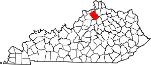
Location of Owen County in Kentucky
This is intended to be a complete list of the properties and districts on the National Register of Historic Places in Owen County, Kentucky, United States. The locations of National Register properties and districts for which the latitude and longitude coordinates are included below, may be seen in a map.[1]
There are 17 properties and districts listed on the National Register in the county.
- This National Park Service list is complete through NPS recent listings posted February 5, 2021.[2]
Current listings
| [3] | Name on the Register | Image | Date listed[4] | Location | City or town | Description |
|---|---|---|---|---|---|---|
| 1 | Mason Brown House | April 27, 1998 (#98000325) |
0.5 miles east of end of Brown's Bottom Rd. 38°25′52″N 84°56′28″W |
Gratz | ||
| 2 | Byrns Landing | August 19, 1997 (#97000865) |
Old Landing Rd. 38°25′23″N 84°53′07″W |
Owenton | ||
| 3 | Central Owenton Historic District | 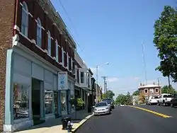 Central Owenton Historic District |
September 4, 1984 (#84001893) |
Roughly Bryan, Madison, Seminary, and Thomas Sts. 38°32′10″N 84°50′14″W |
Owenton | |
| 4 | L.O. Cox House | 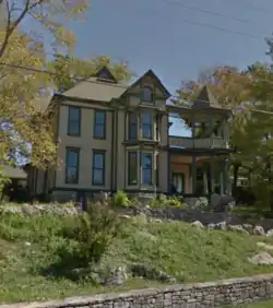 L.O. Cox House |
September 4, 1984 (#84001895) |
311 N. Main St. 38°32′22″N 84°50′12″W |
Owenton | |
| 5 | Ford House |  Ford House |
September 4, 1984 (#84001897) |
311 S. Main St. 38°31′59″N 84°50′05″W |
Owenton | |
| 6 | Enos Hardin Farm | August 8, 1997 (#97000868) |
Junction of Rock Rd. and the Kentucky River 38°22′55″N 84°53′45″W |
Owenton | ||
| 7 | Highfield |  Highfield |
November 17, 1977 (#77000640) |
303 N. Adams St. 38°32′18″N 84°50′06″W |
Owenton | |
| 8 | Jacob Hunter House | January 8, 1987 (#87000204) |
Off Kentucky Route 325 near the Big South Fork of the Kentucky River 38°33′18″N 84°57′47″W |
New Liberty | ||
| 9 | William Linsey House | 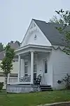 William Linsey House |
September 4, 1984 (#84001900) |
220 W. Seminary St. 38°32′11″N 84°50′19″W |
Owenton | |
| 10 | McKay House | 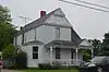 McKay House |
September 4, 1984 (#84001902) |
105 E. Adair St. 38°32′04″N 84°50′08″W |
Owenton | |
| 11 | Monterey Grade School | August 19, 1997 (#97000869) |
9725 U.S. Route 127 S. 38°25′52″N 84°52′17″W |
Owenton | ||
| 12 | Monterey Historic District | August 19, 1997 (#97000867) |
Roughly bounded by U.S. Route 127, High, Hillcrest, and Taylor Sts. 38°25′20″N 84°52′22″W |
Monterey | Covers about 14 blocks. | |
| 13 | New Liberty Historic District | January 4, 2001 (#00001601) |
Kentucky Route 227, roughly between Kentucky Routes 36 and 978 38°36′52″N 84°54′27″W |
New Liberty | ||
| 14 | North Main-North Adams Historic District | 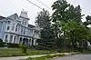 North Main-North Adams Historic District |
September 4, 1984 (#84001905) |
N. Main, N. Adams, Bryan, and North Sts. 38°32′18″N 84°50′07″W |
Owenton | |
| 15 | Old Cedar Baptist Church | September 5, 1997 (#97000870) |
1040 Claxon Ridge Rd. 38°23′49″N 84°50′55″W |
Owenton | ||
| 16 | Owen County Courthouse and Jail | 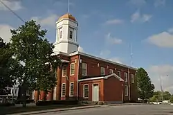 Owen County Courthouse and Jail |
May 6, 1976 (#76000937) |
N. Thomas and N. Madison Sts. 38°32′10″N 84°50′15″W |
Owenton | |
| 17 | E.E. Settle House | 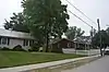 E.E. Settle House |
September 4, 1984 (#84001910) |
403-405 N. Adams St. 38°32′27″N 84°50′09″W |
Owenton |
See also
| Wikimedia Commons has media related to National Register of Historic Places in Owen County, Kentucky. |
References
- The latitude and longitude information provided in this table was derived originally from the National Register Information System, which has been found to be fairly accurate for about 99% of listings. Some locations in this table may have been corrected to current GPS standards.
- "National Register of Historic Places: Weekly List Actions". National Park Service, United States Department of the Interior. Retrieved on February 5, 2021.
- Numbers represent an alphabetical ordering by significant words. Various colorings, defined here, differentiate National Historic Landmarks and historic districts from other NRHP buildings, structures, sites or objects.
- The eight-digit number below each date is the number assigned to each location in the National Register Information System database, which can be viewed by clicking the number.
| Topics | |
|---|---|
| Lists by state |
|
| Lists by insular areas | |
| Lists by associated state | |
| Other areas | |
| Related | |
| |
Municipalities and communities of Owen County, Kentucky, United States | ||
|---|---|---|
| Cities | Location of Owen County, Kentucky | |
| Unincorporated communities | ||
| Ghost town | ||
| Footnotes | ‡This populated place also has portions in an adjacent county or counties | |
| ||
This article is issued from Wikipedia. The text is licensed under Creative Commons - Attribution - Sharealike. Additional terms may apply for the media files.