National Register of Historic Places listings in Green County, Kentucky
This is a list of the National Register of Historic Places listings in Green County, Kentucky.

Location of Green County in Kentucky
This is intended to be a complete list of the properties and districts on the National Register of Historic Places in Green County, Kentucky, United States. The locations of National Register properties and districts for which the latitude and longitude coordinates are included below, may be seen in a map.[1]
There are 46 properties and districts listed on the National Register in the county.
- This National Park Service list is complete through NPS recent listings posted January 29, 2021.[2]
Current listings
| [3] | Name on the Register | Image | Date listed[4] | Location | City or town | Description |
|---|---|---|---|---|---|---|
| 1 | James Allen's Inn | 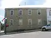 James Allen's Inn |
January 8, 1987 (#87000206) |
103 E. Court St. 37°15′38″N 85°30′05″W |
Greensburg | |
| 2 | John C. Allen House | April 19, 1985 (#85000917) |
Kentucky Route 61 37°18′41″N 85°30′44″W |
Summersville | ||
| 3 | Anderson House | August 24, 1984 (#84001496) |
Kentucky Route 1913 37°11′37″N 85°23′09″W |
Haskingsville | ||
| 4 | Barrett-Blakeman House | 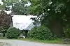 Barrett-Blakeman House |
April 19, 1985 (#85000909) |
Hodgenville Rd. 37°15′52″N 85°30′15″W |
Greensburg | |
| 5 | Brents-Lisle House | August 24, 1984 (#84001501) |
U.S. Route 68 37°13′45″N 85°30′17″W |
Greensburg | ||
| 6 | Chewning House | August 24, 1984 (#84001502) |
Kentucky Route 88 37°14′13″N 85°37′35″W |
Donansburg | ||
| 7 | Christopher Columbus Christie House | 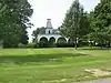 Christopher Columbus Christie House |
August 24, 1984 (#84001503) |
Kentucky Route 1915 37°11′26″N 85°23′18″W |
Haskingsville | |
| 8 | Court Clerk's Office-County & Circuit | 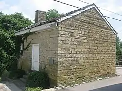 Court Clerk's Office-County & Circuit |
January 8, 1987 (#87000176) |
East Court St. 37°15′37″N 85°30′04″W |
Greensburg | |
| 9 | Francis Cowherd House | April 19, 1985 (#85000908) |
Off U.S. Route 68 37°18′41″N 85°30′44″W |
Greensburg | ||
| 10 | Creal Store | August 24, 1984 (#84001504) |
Kentucky Route 61 37°25′40″N 85°38′13″W |
Creal | ||
| 11 | Elijah Creel House |  Elijah Creel House |
December 3, 2008 (#85003589) |
E. Columbia Ave. 37°15′28″N 85°29′57″W |
Greensburg | |
| 12 | Downtown Greensburg Historic District | 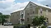 Downtown Greensburg Historic District |
February 28, 2003 (#02001466) |
Public Square and area bounded by N. and S. Main St. and E. and W. Court Sts. 37°15′40″N 85°30′08″W |
Greensburg | |
| 13 | Ebenezer School | 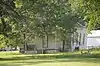 Ebenezer School |
August 24, 1984 (#84001505) |
Off Kentucky Route 61 37°12′38″N 85°26′34″W |
Greensburg | |
| 14 | Edwards House | August 24, 1984 (#84001507) |
Kentucky Route 745 37°07′41″N 85°32′08″W |
Exie | ||
| 15 | David Edwards House | August 24, 1984 (#84001506) |
Off Kentucky Route 745 37°06′54″N 85°33′21″W |
Exie | ||
| 16 | Elmore-Carter House | 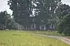 Elmore-Carter House |
August 24, 1984 (#84001508) |
Kentucky Route 793 37°19′20″N 85°30′17″W |
Summersville | |
| 17 | Emory-Blakeman-Penick House | 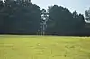 Emory-Blakeman-Penick House |
August 24, 1984 (#84001509) |
Off Kentucky Route 487 37°15′21″N 85°27′44″W |
Greensburg | |
| 18 | Federal House | 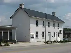 Federal House |
April 19, 1985 (#85000910) |
S. Main and E. Columbia 37°15′33″N 85°30′09″W |
Greensburg | |
| 19 | Goose Creek Foot Bridge | 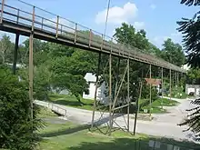 Goose Creek Foot Bridge |
April 19, 1985 (#85000911) |
Court and Depot Sts. 37°15′37″N 85°30′00″W |
Greensburg | |
| 20 | Greensburg Academy |  Greensburg Academy |
December 12, 1976 (#76000891) |
101 2nd St. 37°15′41″N 85°30′18″W |
Greensburg | |
| 21 | Greensburg Bank Building | 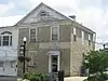 Greensburg Bank Building |
August 21, 1979 (#79000991) |
E. Court St. 37°15′37″N 85°30′05″W |
Greensburg | |
| 22 | Greensburg Cumberland Presbyterian Church | 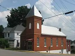 Greensburg Cumberland Presbyterian Church |
April 19, 1985 (#85000912) |
Hodgenville Ave. and N. 1st St. 37°15′45″N 85°30′08″W |
Greensburg | |
| 23 | Groves-Cabell House | August 24, 1984 (#84001510) |
Off Kentucky Route 61 37°11′02″N 85°25′34″W |
Gresham | ||
| 24 | William H. Herndon House | 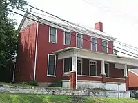 William H. Herndon House |
April 19, 1985 (#85000913) |
203 S. Main St. 37°15′31″N 85°30′10″W |
Greensburg | |
| 25 | David Hilliard House | August 24, 1984 (#84001511) |
Off Kentucky Route 487 37°14′55″N 85°26′27″W |
Greensburg | ||
| 26 | William Hobson House | 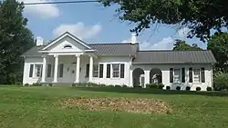 William Hobson House |
April 19, 1985 (#85000914) |
102 S. Depot St. 37°15′33″N 85°29′56″W |
Greensburg | |
| 27 | Keltner House | August 24, 1984 (#84001512) |
Kentucky Route 1913 37°11′38″N 85°22′42″W |
Haskingsville | ||
| 28 | L & N Passenger Depot | 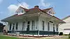 L & N Passenger Depot |
August 24, 1984 (#84001513) |
103 N. Depot St. 37°15′36″N 85°29′57″W |
Greensburg | |
| 29 | Woodson Lewis House | 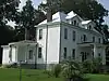 Woodson Lewis House |
April 19, 1985 (#85000915) |
Main St. and Hodgenville Ave. 37°15′45″N 85°30′04″W |
Greensburg | |
| 30 | Livesay House | August 24, 1984 (#84001514) |
Off Kentucky Route 208 37°16′09″N 85°25′36″W |
Campbellsville | ||
| 31 | Mears House | August 24, 1984 (#84001517) |
Kentucky Route 61 37°18′06″N 85°30′57″W |
Greensburg | ||
| 32 | Montgomery House | August 24, 1984 (#84001521) |
Off Kentucky Route 1464 37°16′27″N 85°38′25″W |
Donansburg | ||
| 33 | Montgomery-Sandidge House | August 2, 2017 (#100001421) |
1851 Columbia Hwy. 37°14′12″N 85°29′36″W |
Greensburg | ||
| 34 | Montgomery's Mill | August 24, 1984 (#84001523) |
Off Kentucky Route 88 37°16′24″N 85°33′14″W |
Greensburg | ||
| 35 | Mt. Gilead Baptist Church | 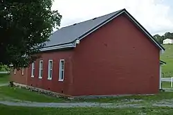 Mt. Gilead Baptist Church |
August 24, 1984 (#84001519) |
Kentucky Route 767 37°10′13″N 85°22′56″W |
Haskingsville | |
| 36 | Mud Brick House in Greensburg | 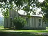 Mud Brick House in Greensburg |
February 3, 2010 (#09001307) |
429 Campbellsville Rd. 37°16′08″N 85°29′54″W |
Greensburg | |
| 37 | Old Courthouse | 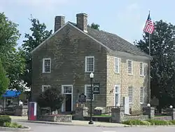 Old Courthouse |
April 10, 1972 (#72000533) |
Public Sq. 37°15′38″N 85°30′06″W |
Greensburg | |
| 38 | Philpot House | April 19, 1985 (#85000907) |
Kentucky Route 729 37°08′46″N 85°36′07″W |
Exie | ||
| 39 | Sandidge House | August 24, 1984 (#84001525) |
Kentucky Route 88 37°13′31″N 85°39′42″W |
Donansburg | ||
| 40 | Simpson Log House | August 24, 1984 (#84001526) |
Kentucky Route 1464 37°15′30″N 85°36′43″W |
Webbs | ||
| 41 | Napoleon Wallace House | August 24, 1984 (#84001527) |
Off Kentucky Route 218 37°11′01″N 85°37′25″W |
Pierce | ||
| 42 | Webbs Female Academy | 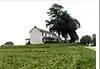 Webbs Female Academy |
August 24, 1984 (#84001528) |
Off Kentucky Route 88 37°15′33″N 85°36′08″W |
Webbs | |
| 43 | White-Penick House |  White-Penick House |
April 19, 1985 (#85000916) |
106 S. Depot St. 37°15′30″N 85°29′58″W |
Greensburg | |
| 44 | Whitlock Log Cabin | 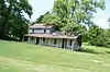 Whitlock Log Cabin |
August 24, 1984 (#84001529) |
U.S. Route 68 37°09′32″N 85°32′13″W |
Exie | |
| 45 | Daniel Motley Williams House | August 24, 1984 (#84001531) |
Kentucky Route 323 37°21′11″N 85°29′28″W |
Summersville | ||
| 46 | R.H. Wilson House | 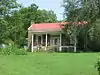 R.H. Wilson House |
August 24, 1984 (#84001532) |
402 N. Water St. 37°15′43″N 85°29′56″W |
Greensburg | |
| 47 | Woodward House | August 24, 1984 (#84001534) |
Off U.S. Route 68 37°12′53″N 85°33′29″W |
Greensburg |
See also
| Wikimedia Commons has media related to National Register of Historic Places in Green County, Kentucky. |
References
- The latitude and longitude information provided in this table was derived originally from the National Register Information System, which has been found to be fairly accurate for about 99% of listings. Some locations in this table may have been corrected to current GPS standards.
- "National Register of Historic Places: Weekly List Actions". National Park Service, United States Department of the Interior. Retrieved on January 29, 2021.
- Numbers represent an alphabetical ordering by significant words. Various colorings, defined here, differentiate National Historic Landmarks and historic districts from other NRHP buildings, structures, sites or objects.
- The eight-digit number below each date is the number assigned to each location in the National Register Information System database, which can be viewed by clicking the number.
| Topics | |
|---|---|
| Lists by state |
|
| Lists by insular areas | |
| Lists by associated state | |
| Other areas | |
| Related | |
| |
Municipalities and communities of Green County, Kentucky, United States | ||
|---|---|---|
| City | Location of Green County, Kentucky | |
| CDP | ||
| Other unincorporated communities | ||
| ||
This article is issued from Wikipedia. The text is licensed under Creative Commons - Attribution - Sharealike. Additional terms may apply for the media files.