National Register of Historic Places listings in Bracken County, Kentucky
This is a list of the National Register of Historic Places listings in Bracken County, Kentucky.

Location of Bracken County in Kentucky
This is intended to be a complete list of the properties and districts on the National Register of Historic Places in Bracken County, Kentucky, United States. The locations of National Register properties and districts for which the latitude and longitude coordinates are included below, may be seen in a map.[1]
There are 23 properties and districts listed on the National Register in the county.
- This National Park Service list is complete through NPS recent listings posted February 5, 2021.[2]
Current listings
| [3] | Name on the Register | Image | Date listed[4] | Location | City or town | Description |
|---|---|---|---|---|---|---|
| 1 | Augusta College Historic Buildings | 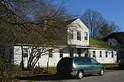 Augusta College Historic Buildings |
February 20, 1980 (#80001486) |
205 Frankfort St. and 204 Bracken St. 38°46′27″N 84°00′09″W |
Augusta | |
| 2 | Augusta Historic District |  Augusta Historic District |
March 13, 1984 (#84001385) |
Roughly bounded by Riverside Dr., 5th, Frankfort, and Williams Sts. 38°46′21″N 84°00′21″W |
Augusta | |
| 3 | Baker Vineyard and Wine Cellar | 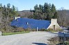 Baker Vineyard and Wine Cellar |
December 30, 1974 (#74000855) |
South of Augusta on Kentucky Route 1839; also 4465 W. Augusta-Chatham Rd. 38°46′07″N 83°59′39″W |
Augusta | Augusta-Chatham Road address represents a boundary increase of July 11, 2007 |
| 4 | George W. Barkley Farm | 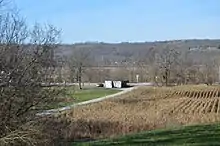 George W. Barkley Farm |
June 18, 2003 (#03000259) |
Kentucky Route 8 38°46′39″N 83°57′58″W |
Augusta | |
| 5 | Bold House | March 13, 2017 (#100000734) |
98 Main St. 38°47′55″N 84°12′48″W |
Foster | ||
| 6 | Bracken County Infirmary | 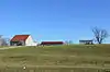 Bracken County Infirmary |
April 16, 1979 (#79000966) |
Northeast of Chatham on Kentucky Route 19 38°43′02″N 84°00′48″W |
Chatham | |
| 7 | Bradford School House | 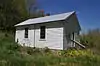 Bradford School House |
June 18, 2003 (#03000263) |
Kentucky Routes 8 and 1109 38°46′50″N 84°08′25″W |
Foster | |
| 8 | Brothers-O'Neil House | 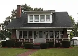 Brothers-O'Neil House |
May 22, 1984 (#84001390) |
308 Seminary Rd. 38°46′23″N 84°00′00″W |
Augusta | |
| 9 | Mordecai Chalfant House | 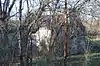 Mordecai Chalfant House |
January 8, 1987 (#87000142) |
Kentucky Route 8 38°46′01″N 84°04′58″W |
Augusta | |
| 10 | Confederate Monument in Augusta | 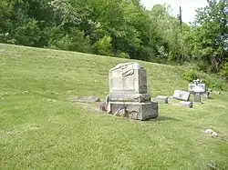 Confederate Monument in Augusta |
July 17, 1997 (#97000715) |
Payne Cemetery, north of Kentucky Route 8 38°46′09″N 84°00′44″W |
Augusta | |
| 11 | John Gregg Fee House | August 26, 1980 (#80001487) |
Northwest of Germantown 38°41′32″N 83°59′37″W |
Germantown | ||
| 12 | Evan Griffith's Grocery | 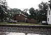 Evan Griffith's Grocery |
May 22, 1984 (#84001392) |
415 Railroad Ave. 38°46′25″N 84°00′04″W |
Augusta | |
| 13 | Alfonso McKibben House | 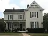 Alfonso McKibben House |
May 22, 1984 (#84001394) |
202 4th St. 38°46′13″N 84°00′30″W |
Augusta | |
| 14 | J. R. Minor House | 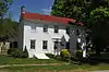 J. R. Minor House |
May 22, 1984 (#84001395) |
204 2nd St. 38°46′24″N 84°00′34″W |
Augusta | |
| 15 | Rock Spring Warehouse | 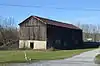 Rock Spring Warehouse |
January 8, 1987 (#87000175) |
Kentucky Route 8 38°46′06″N 84°05′34″W |
Wellsburg | |
| 16 | Snag Creek Site (15BK2) | 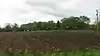 Snag Creek Site (15BK2) |
November 14, 1985 (#85002821) |
Western side of Snag Creek, 0.25 miles (0.40 km) south of the Ohio River[5] 38°47′17″N 84°10′09″W |
Willow Grove | Extends west as far as Snag Creek Road[5] |
| 17 | Stone House on Bracken Creek | January 8, 1987 (#87000199) |
Off Kentucky Route 435 38°45′11″N 83°57′57″W |
Augusta | ||
| 18 | Stroube House | 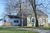 Stroube House |
January 8, 1987 (#87000140) |
Kentucky Route 616 38°45′01″N 83°59′13″W |
Augusta | |
| 19 | Turtle Creek Site (15BK13) | November 14, 1985 (#85002824) |
Ohio River bank, west of Augusta[6] 38°46′11″N 84°01′39″W |
Augusta | ||
| 20 | Walcott Covered Bridge |  Walcott Covered Bridge |
June 10, 1975 (#75000738) |
3.5 miles north of Brooksville on Kentucky Route 1159 over Locust Creek 38°44′00″N 84°06′02″W |
Brooksville | |
| 21 | Water Street Historic District | 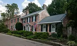 Water Street Historic District |
September 24, 1975 (#75000737) |
River Side Drive east to Frankfort Street and west to Ferry Street 38°46′28″N 84°00′28″W |
Augusta | |
| 22 | James Weldon House | 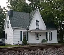 James Weldon House |
May 22, 1984 (#84001384) |
417 Railroad St. 38°46′25″N 84°00′03″W |
Augusta | |
| 23 | Wells-Keith House | 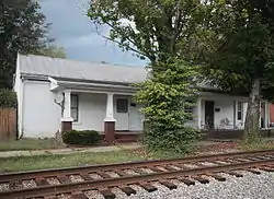 Wells-Keith House |
May 22, 1984 (#84001398) |
411-413 3rd St. 38°46′24″N 84°00′05″W |
Augusta |
See also
| Wikimedia Commons has media related to National Register of Historic Places in Bracken County, Kentucky. |
References
- The latitude and longitude information provided in this table was derived originally from the National Register Information System, which has been found to be fairly accurate for about 99% of listings. Some locations in this table may have been corrected to current GPS standards.
- "National Register of Historic Places: Weekly List Actions". National Park Service, United States Department of the Interior. Retrieved on February 5, 2021.
- Numbers represent an alphabetical ordering by significant words. Various colorings, defined here, differentiate National Historic Landmarks and historic districts from other NRHP buildings, structures, sites or objects.
- The eight-digit number below each date is the number assigned to each location in the National Register Information System database, which can be viewed by clicking the number.
- Pollack, David, and Cynthia E. Jobe. "The Snag Creek Site". Fort Ancient Cultural Dynamics in the Middle Ohio Valley. A. Gwynn Henderson, ed. Madison: Prehistory, 1992. 69-82: 69-70.
- Pollack, David, ed. The Archaeology of Kentucky: An Update. Frankfort: Kentucky Heritage Council, 2008, 69.
| Topics | |
|---|---|
| Lists by state |
|
| Lists by insular areas | |
| Lists by associated state | |
| Other areas | |
| Related | |
| |
Municipalities and communities of Bracken County, Kentucky, United States | ||
|---|---|---|
| Cities | Location of Bracken County, Kentucky | |
| Unincorporated communities | ||
| Ghost towns | ||
| Footnotes | ‡This populated place also has portions in an adjacent county or counties | |
| ||
This article is issued from Wikipedia. The text is licensed under Creative Commons - Attribution - Sharealike. Additional terms may apply for the media files.