National Register of Historic Places listings in Fleming County, Kentucky
This is a list of the National Register of Historic Places listings in Fleming County, Kentucky.

Location of Fleming County in Kentucky
This is intended to be a complete list of the properties and districts on the National Register of Historic Places in Fleming County, Kentucky, United States. The locations of National Register properties and districts for which the latitude and longitude coordinates are included below, may be seen in a map.[1]
There are 10 properties and districts listed on the National Register in the county. Another property was once listed but has been removed.
- This National Park Service list is complete through NPS recent listings posted February 5, 2021.[2]
Current listings
| [3] | Name on the Register | Image | Date listed[4] | Location | City or town | Description |
|---|---|---|---|---|---|---|
| 1 | Elizaville Presbyterian Church |  Elizaville Presbyterian Church |
June 17, 1977 (#77000616) |
Kentucky Route 32 38°25′10″N 83°49′27″W |
Elizaville | |
| 2 | First Presbyterian Church | 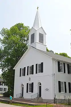 First Presbyterian Church |
August 12, 1977 (#77000617) |
W. Main and W. Water Sts. 38°25′28″N 83°44′10″W |
Flemingsburg | |
| 3 | Thomas W. Fleming House | 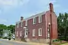 Thomas W. Fleming House |
March 21, 1979 (#79000983) |
114 W. Water St. 38°25′22″N 83°44′04″W |
Flemingsburg | |
| 4 | Flemingsburg Historic District | 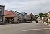 Flemingsburg Historic District |
July 5, 1985 (#85001479) |
Roughly bounded by Stockwell, Hunt, East Elm, Foxsprings, Mt. Sterling, Main Cross, and Rhoades 38°25′20″N 83°44′03″W |
Flemingsburg | |
| 5 | Goddard Bridge | 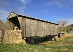 Goddard Bridge |
August 22, 1975 (#75000756) |
Maddox Rd. at Kentucky Route 32 38°21′44″N 83°36′56″W |
Goddard | |
| 6 | Hillsboro Covered Bridge | 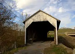 Hillsboro Covered Bridge |
March 26, 1976 (#76000881) |
South of Hillsboro on Kentucky Route 111 38°15′17″N 83°39′11″W |
Hillsboro | |
| 7 | Ben Johnson House | March 1, 1982 (#82002697) |
Kentucky Route 161 38°27′56″N 83°49′19″W |
Flemingsburg Junction | ||
| 8 | Abraham Magowan House | June 30, 1983 (#83002772) |
Maddox Pike 38°27′19″N 83°40′19″W |
Flemingsburg | ||
| 9 | Ringos Mill Covered Bridge | 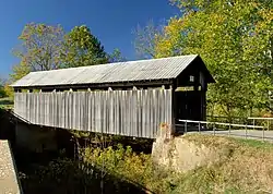 Ringos Mill Covered Bridge |
March 26, 1976 (#76000880) |
13.7 miles south of Flemingsburg on Kentucky Route 158 38°16′06″N 83°36′38″W |
Flemingsburg | |
| 10 | Franklin R. Sousley Birthplace | December 31, 1974 (#74000870) |
4 miles southwest of Elizaville on Kentucky Route 170 38°21′54″N 83°50′31″W |
Elizaville |
Former listing
| [3] | Name on the Register | Image | Date listed | Date removed | Location | City or town | Summary |
|---|---|---|---|---|---|---|---|
| 1 | Sherburne Covered Suspension Bridge | March 26, 1976 (#76000882) | February 6, 1990 | KY 11 at Licking River |
Sherburne |
See also
| Wikimedia Commons has media related to National Register of Historic Places in Fleming County, Kentucky. |
References
- The latitude and longitude information provided in this table was derived originally from the National Register Information System, which has been found to be fairly accurate for about 99% of listings. Some locations in this table may have been corrected to current GPS standards.
- "National Register of Historic Places: Weekly List Actions". National Park Service, United States Department of the Interior. Retrieved on February 5, 2021.
- Numbers represent an alphabetical ordering by significant words. Various colorings, defined here, differentiate National Historic Landmarks and historic districts from other NRHP buildings, structures, sites or objects.
- The eight-digit number below each date is the number assigned to each location in the National Register Information System database, which can be viewed by clicking the number.
| Topics | |
|---|---|
| Lists by state |
|
| Lists by insular areas | |
| Lists by associated state | |
| Other areas | |
| Related | |
| |
Municipalities and communities of Fleming County, Kentucky, United States | ||
|---|---|---|
| Cities | Location of Fleming County, Kentucky | |
| CDP | ||
| Other unincorporated communities | ||
| ||
This article is issued from Wikipedia. The text is licensed under Creative Commons - Attribution - Sharealike. Additional terms may apply for the media files.