National Register of Historic Places listings in LaRue County, Kentucky
This is a list of the National Register of Historic Places listings in LaRue County, Kentucky.
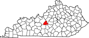
Location of LaRue County in Kentucky
This is intended to be a complete list of the properties and districts on the National Register of Historic Places in LaRue County, Kentucky, United States. The locations of National Register properties and districts for which the latitude and longitude coordinates are included below, may be seen in a map.[1]
There are 31 properties and districts listed on the National Register in the county.
- This National Park Service list is complete through NPS recent listings posted January 29, 2021.[2]
Current listings
| [3] | Name on the Register | Image | Date listed[4] | Location | City or town | Description |
|---|---|---|---|---|---|---|
| 1 | Abraham Lincoln Birthplace National Historic Site | 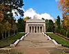 Abraham Lincoln Birthplace National Historic Site |
October 15, 1966 (#66000066) |
3 miles south of Hodgenville 37°31′49″N 85°43′33″W |
Hodgenville | 1809 birthplace of Abraham Lincoln, containing a portion of his parents' farm and a traditional log cabin now housed in a 1911 memorial designed by John Russell Pope.[5] |
| 2 | Aaron Atherton House | January 10, 1991 (#90001962) |
U.S. Route 31E south of Athertonville 37°37′33″N 85°36′56″W |
Hodgenville | ||
| 3 | Dorsey Beeler House | January 10, 1991 (#90001963) |
Edlin Rd. east of Lyons 37°40′48″N 85°35′48″W |
Hodgenville | ||
| 4 | Brown House | January 10, 1991 (#90001964) |
Kentucky Route 462 west of Gleanings 37°33′32″N 85°32′42″W |
Hodgenville | ||
| 5 | Buffalo School | February 4, 2009 (#09000005) |
50 School Loop 37°30′33″N 85°41′53″W |
Buffalo | ||
| 6 | Walter Burch House | January 10, 1991 (#90001965) |
Spaulding Rd. 37°37′12″N 85°36′24″W |
Hodgenville | ||
| 7 | Nicholas Carter House | January 10, 1991 (#90001966) |
Carter Brothers Rd. 37°37′34″N 85°45′33″W |
Hodgenville | ||
| 8 | Edward S. Ferrill House | January 10, 1991 (#90001967) |
Kentucky Route 470 north of its junction with Kentucky Route 61 37°30′42″N 85°41′45″W |
Buffalo | ||
| 9 | Albert Goodin House | January 10, 1991 (#90001968) |
Kentucky Route 64 northeast of Tonieville 37°36′54″N 85°47′06″W |
Hodgenville | ||
| 10 | Hodgenville Christian Church | 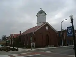 Hodgenville Christian Church |
December 20, 1977 (#77000633) |
100 W. Main St. 37°34′25″N 85°44′28″W |
Hodgenville | |
| 11 | Hodgenville Commercial Historic District | 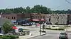 Hodgenville Commercial Historic District |
November 10, 1988 (#88002540) |
Public Sq. and N. Lincoln Boulevard; also Water St. on the north, High St. on the south, Greensburg St. on the east, and Walters St. on the west 37°34′27″N 85°44′27″W |
Hodgenville | Second set of boundaries represents a boundary increase of December 28, 2009 |
| 12 | Hodgenville Women's Club | 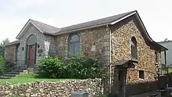 Hodgenville Women's Club |
January 10, 1991 (#90001969) |
Public Sq. 37°34′24″N 85°29′24″W |
Hodgenville | |
| 13 | Joseph Kirkpatrick Springhouse | January 10, 1991 (#90001970) |
U.S. Route 31E west of its junction with County Road 1832 37°35′09″N 85°42′07″W |
Hodgenville | ||
| 14 | LaRue County Jail | 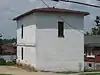 LaRue County Jail |
January 10, 1991 (#90001971) |
E. High St. south of its junction with U.S. Route 31E 37°34′22″N 85°44′24″W |
Hodgenville | |
| 15 | Lincoln Boyhood Home | 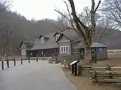 Lincoln Boyhood Home |
November 16, 1988 (#88002531) |
U.S. Route 31E, 1 mile south of Athertonville 37°36′41″N 85°38′17″W |
Athertonville | |
| 16 | Abraham Lincoln Statue | 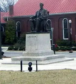 Abraham Lincoln Statue |
January 10, 1991 (#90001972) |
Public Square 37°34′25″N 85°44′26″W |
Hodgenville | |
| 17 | Nancy Lincoln Inn | 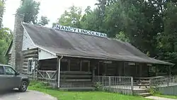 Nancy Lincoln Inn |
January 10, 1991 (#90001973) |
U.S. Route 31E, Lincoln Memorial National Historic Park 37°31′48″N 85°44′12″W |
Hodgenville | |
| 18 | McClain Hotel | January 10, 1991 (#90001974) |
Kentucky Route 470 south of its junction with Kentucky Route 61 37°30′35″N 85°42′02″W |
Buffalo | ||
| 19 | William Miller House | 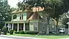 William Miller House |
January 10, 1991 (#90001975) |
211 W. Water St. 37°34′30″N 85°44′35″W |
Hodgenville | |
| 20 | Miller-Blanton House | January 10, 1991 (#90001976) |
Blanton Rd. east of Athertonville 37°37′37″N 85°34′44″W |
New Haven | ||
| 21 | New Haven Battlefield Site | August 4, 2004 (#04000793) |
Lyons Station Rd. 37°39′42″N 85°36′04″W |
New Haven | ||
| 22 | Nolynn Baptist Church | April 18, 1991 (#90001977) |
Kentucky Route 222 southeast of its junction with McCubbin-Harned Rd. 37°33′37″N 85°47′24″W |
Hodgenville | ||
| 23 | Thomas Patterson House | January 10, 1991 (#90001978) |
Kentucky Route 84 west of Mathers Mill 37°32′17″N 85°47′51″W |
Hodgenville | ||
| 24 | William Phillips House | January 10, 1991 (#90001979) |
Kentucky Route 84 east of its junction with County Road 1517 37°32′00″N 85°49′06″W |
Hodgenville | ||
| 25 | Saunders-Boyd House | 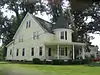 Saunders-Boyd House |
January 10, 1991 (#90001980) |
118 Forest Ave. 37°34′11″N 85°44′33″W |
Hodgenville | |
| 26 | School No. 20 | January 10, 1991 (#90001981) |
Stack Rd. 37°38′50″N 85°43′06″W |
Hodgenville | ||
| 27 | School No. 24 | January 10, 1991 (#90001982) |
McCubbin-Harned Rd. north of its junction with Kentucky Route 222 37°34′32″N 85°47′38″W |
Hodgenville | ||
| 28 | David H. Smith House | 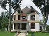 David H. Smith House |
January 10, 1991 (#90001983) |
223 Greensburg Ave. 37°34′20″N 85°44′15″W |
Hodgenville | |
| 29 | R.H. Thomas House | January 10, 1991 (#90001984) |
Brooks Rd. west of its junction with Kentucky Route 470 37°30′15″N 85°43′54″W |
Hodgenville | ||
| 30 | Tonieville Store | January 10, 1991 (#90001985) |
Tonieville-Glendale Rd. north of its junction with Kentucky Route 61 37°36′35″N 85°47′45″W |
Hodgenville | ||
| 31 | Thomas Walters House | January 10, 1991 (#90001986) |
U.S. Route 31E north of Magnolia 37°28′39″N 85°44′31″W |
Hodgenville |
See also
| Wikimedia Commons has media related to National Register of Historic Places in LaRue County, Kentucky. |
References
- The latitude and longitude information provided in this table was derived originally from the National Register Information System, which has been found to be fairly accurate for about 99% of listings. Some locations in this table may have been corrected to current GPS standards.
- "National Register of Historic Places: Weekly List Actions". National Park Service, United States Department of the Interior. Retrieved on January 29, 2021.
- Numbers represent an alphabetical ordering by significant words. Various colorings, defined here, differentiate National Historic Landmarks and historic districts from other NRHP buildings, structures, sites or objects.
- The eight-digit number below each date is the number assigned to each location in the National Register Information System database, which can be viewed by clicking the number.
- Loveless, Andrew M. (1976-04-29). "National Register of Historic Places Registration Form: Abraham Lincoln Birthplace National Historic Site". National Park Service. Retrieved 2013-03-23. Cite journal requires
|journal=(help)
| Topics | |
|---|---|
| Lists by state |
|
| Lists by insular areas | |
| Lists by associated state | |
| Other areas | |
| Related | |
| |
Municipalities and communities of LaRue County, Kentucky, United States | ||
|---|---|---|
| Cities | Location of LaRue County, Kentucky | |
| CDPs | ||
| Other unincorporated communities | ||
| Footnotes | ‡This populated place also has portions in an adjacent county or counties | |
| ||
This article is issued from Wikipedia. The text is licensed under Creative Commons - Attribution - Sharealike. Additional terms may apply for the media files.