National Register of Historic Places listings in Clark County, Kentucky
This is a list of the National Register of Historic Places listings in Clark County, Kentucky.
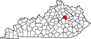
Location of Clark County in Kentucky
This is intended to be a complete list of the properties and districts on the National Register of Historic Places in Clark County, Kentucky, United States. The locations of National Register properties and districts for which the latitude and longitude coordinates are included below, may be seen in a map.[1]
There are 68 properties and districts listed on the National Register in the county.
- This National Park Service list is complete through NPS recent listings posted February 5, 2021.[2]
Current listings
| [3] | Name on the Register | Image | Date listed[4] | Location | City or town | Description |
|---|---|---|---|---|---|---|
| 1 | Antioch Christian Church | August 1, 1979 (#79003566) |
Off Muddy Creek Rd. at Four Mile Creek and Stone Branch 37°54′28″N 84°10′06″W |
Winchester | ||
| 2 | Boone Creek Rural Historic District | August 19, 1994 (#94000839) |
Roughly bounded by Interstate 75, Cleveland Rd., Athens-Boonesboro Rd. and Grimes Rd. 37°55′02″N 84°19′36″W |
Lexington | Extends into Fayette County | |
| 3 | Boot Hill Farm |  Boot Hill Farm |
March 1, 1985 (#85000374) |
Athens-Boonesboro Pike (KY 418) 37°55′53″N 84°20′22″W |
Athens | |
| 4 | Brock House | August 1, 1979 (#79003567) |
Off Red River Rd. 37°52′09″N 84°06′11″W |
Bloomingdale | ||
| 5 | Brown-Proctoria Hotel |  Brown-Proctoria Hotel |
July 29, 1977 (#77000609) |
Main St. and Lexington Ave. 37°59′28″N 84°10′42″W |
Winchester | |
| 6 | Capt. Robert V. Bush House |  Capt. Robert V. Bush House |
August 1, 1979 (#79003568) |
Combs Ferry Rd. 37°58′05″N 84°17′22″W |
Becknerville | |
| 7 | V.W. Bush Warehouse | March 13, 2017 (#100000737) |
127 N. Main St. 37°59′47″N 84°10′32″W |
Winchester | ||
| 8 | W. Bush-Dykes House |  W. Bush-Dykes House |
August 1, 1979 (#79003569) |
U.S. Route 227 37°55′02″N 84°15′26″W |
Forest Grove | |
| 9 | Bybee House | 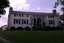 Bybee House |
August 1, 1979 (#79003570) |
Bybee Rd. 37°54′55″N 84°11′05″W |
Winchester | |
| 10 | Henry W. Calmes House | August 1, 1979 (#79003571) |
U.S. Route 227 37°58′45″N 84°18′51″W |
Winchester | ||
| 11 | Tarleton Chiles House |  Tarleton Chiles House |
August 1, 1979 (#79003598) |
Jones Nursery Rd. 37°57′33″N 84°17′18″W |
Becknerville | |
| 12 | Civil War Fort at Boonesboro | June 18, 2003 (#03000262) |
0.6 miles north of Ford, west of Fort Hampton Rd. 37°53′24″N 84°15′32″W |
Ford | ||
| 13 | Clark County Court House | 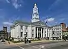 Clark County Court House |
August 7, 1974 (#74000858) |
Main St. 37°59′34″N 84°10′41″W |
Winchester | |
| 14 | Gov. James A. Clark Mansion | 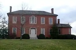 Gov. James A. Clark Mansion |
June 13, 1974 (#74000859) |
Burns Ave. and Belmont St. 37°59′20″N 84°11′16″W |
Winchester | |
| 15 | William Clinkenbeard House |  William Clinkenbeard House |
November 20, 1980 (#80001497) |
Old Paris Pike 38°02′48″N 84°10′42″W |
Winchester | |
| 16 | Colby Tavern | 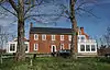 Colby Tavern |
August 1, 1979 (#79003572) |
Junction of Colby and Becknerville Rds. 37°59′34″N 84°15′51″W |
Winchester | |
| 17 | Corinth Christian Methodist Episcopal Church | .jpg.webp) Corinth Christian Methodist Episcopal Church |
July 11, 2007 (#07000678) |
1180 L E Junction Rd. 37°59′54″N 84°03′30″W |
Winchester | |
| 18 | Couchman House | August 1, 1979 (#79003573) |
Off Old Boonesboro Rd. 37°57′20″N 84°10′26″W |
Winchester | ||
| 19 | Frances Cullom, Jr. House | August 1, 1979 (#79003574) |
Muddy Creek Rd. 37°55′08″N 84°09′50″W |
Winchester | ||
| 20 | Elkin House | August 1, 1979 (#79003576) |
Off U.S. Route 227 37°56′19″N 84°13′17″W |
Winchester | ||
| 21 | Achilles Eubank House | August 1, 1979 (#79003577) |
Elkin Rd. 37°54′25″N 84°12′37″W |
Winchester | ||
| 22 | Jesse Fishback House | August 1, 1979 (#79003578) |
Off Combs Ferry Rd. 37°58′50″N 84°18′56″W |
Becknerville | ||
| 23 | John Gibbs House | August 1, 1979 (#79003580) |
Fox-Quisenberry Rd. 37°56′31″N 84°04′00″W |
Pilot View | ||
| 24 | David Gist House | August 1, 1979 (#79003581) |
Stoner Rd. 38°05′01″N 84°06′47″W |
Winchester | ||
| 25 | Strauder Goff House | August 1, 1979 (#79003582) |
Off Van Meter Rd. 38°02′48″N 84°11′54″W |
Winchester | ||
| 26 | Goshen Primitive Baptist Church | 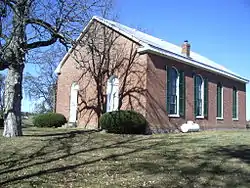 Goshen Primitive Baptist Church |
August 1, 1979 (#79003583) |
Goshen Rd. 38°01′08″N 84°04′15″W |
Winchester | |
| 27 | Nathaniel Haggard House | August 1, 1979 (#79003584) |
Off New Boonesborough Rd. 37°57′35″N 84°12′18″W |
Winchester | ||
| 28 | Jesse Hampton House | August 1, 1979 (#79003585) |
Bybee Rd. 37°55′05″N 84°11′02″W |
Winchester | ||
| 29 | Gen. Thomas Hart House | 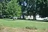 Gen. Thomas Hart House |
August 1, 1979 (#79003586) |
Ecton Rd. 38°00′11″N 84°09′14″W |
Winchester | |
| 30 | William Hickman House | 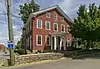 William Hickman House |
November 24, 1982 (#82001554) |
31 W. Hickman St. 37°59′28″N 84°10′48″W |
Winchester | |
| 31 | Hodgkins House | 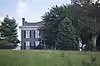 Hodgkins House |
August 1, 1979 (#79003587) |
Old Boonesborough Rd. 37°55′52″N 84°14′07″W |
Winchester | |
| 32 | Dailey-Milton Holliday House | August 1, 1979 (#79003575) |
Jones Nursery Rd. 37°57′00″N 84°18′42″W |
Becknerville | ||
| 33 | Hollywood Springs | August 1, 1979 (#79003588) |
Off Kiddville Rd. 37°56′55″N 83°59′10″W |
Kiddville | ||
| 34 | Hood-Tucker House | 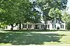 Hood-Tucker House |
January 4, 2007 (#06001201) |
19 French Ave. 37°59′10″N 84°10′44″W |
Winchester | |
| 35 | Indian Fort Earthworks (15CK7) | November 14, 1985 (#85002823) |
Address Restricted |
Goffs Corner | ||
| 36 | Lampton House | August 1, 1979 (#79003589) |
Muddy Creek Rd. 37°56′57″N 84°08′49″W |
Winchester | ||
| 37 | Alpheus Lewis House | August 1, 1979 (#79003590) |
Off Wades Mill Rd. 38°04′32″N 84°06′54″W |
Winchester | ||
| 38 | Jonathan Bush House | August 1, 1979 (#79003591) |
On Lower Howard's Creek 37°55′44″N 84°16′33″W |
Hootentown | Originally listed as the Martin House; renamed 2016-08-09. | |
| 39 | Maj. John Martin House |  Maj. John Martin House |
April 29, 1982 (#82002680) |
Basin Springs Rd. 37°59′23″N 84°17′14″W |
Pine Grove | |
| 40 | Jonathan Bush Mill | November 20, 1980 (#80001498) |
Address Restricted |
Winchester | Originally listed as the Martin-Holder-Bush-Hampton Mill; renamed 2016-08-09. | |
| 41 | Middle Reaches of Boone Creek Rural Historic District | May 31, 1996 (#96000429) |
Roughly bounded by U.S. Route 421, Jones Nursery, Coombs Ferry, Sulpher Well Rds., and U.S. Route 25 37°57′34″N 84°19′17″W |
Lexington | Extends into Fayette County | |
| 42 | Mound Hill Archeological Site |  Mound Hill Archeological Site |
August 25, 1978 (#78001308) |
0.5 miles (0.80 km) west of the Devil's Backbone above Stoner Creek[5] 38°05′49″N 84°08′01″W |
Winchester | |
| 43 | Oliver School | 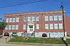 Oliver School |
August 4, 2004 (#04000795) |
30 Oliver St. 37°59′44″N 84°10′47″W |
Winchester | |
| 44 | Owen-Gay Farm | 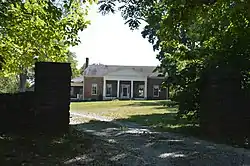 Owen-Gay Farm |
March 13, 1997 (#97000163) |
Gay Rd., junction with Donaldson Rd. at the Bourbon County line 38°06′24″N 84°06′56″W |
Winchester | Extends into Bourbon County |
| 45 | Parrish Place | August 1, 1979 (#79003592) |
Todd-Colby Rd. 37°59′31″N 84°19′14″W |
Pine Grove | ||
| 46 | Col. Edmund Pendleton House | August 1, 1979 (#79003593) |
Van Meter Rd. 38°03′24″N 84°15′09″W |
Clintonville | ||
| 47 | Maj. Walter Preston House | 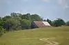 Maj. Walter Preston House |
August 1, 1979 (#79003594) |
Basin Springs Rd. 37°58′45″N 84°17′19″W |
Becknerville | |
| 48 | Providence Baptist Church | 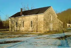 Providence Baptist Church |
May 13, 1976 (#76000864) |
6 miles southwest of Winchester off KY 627 37°56′15″N 84°14′45″W |
Winchester | |
| 49 | W. Pruett House | 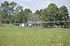 W. Pruett House |
November 20, 1980 (#80001499) |
Ecton Rd. 38°00′40″N 84°02′50″W |
Winchester | |
| 50 | J. Quisenberry House | 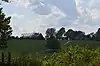 J. Quisenberry House |
August 1, 1979 (#79003596) |
Quisenberry Rd. 37°55′43″N 84°15′04″W |
Forest Grove | |
| 51 | Joel Quisenberry House | August 1, 1979 (#79003595) |
Flanagan Station Rd. 37°56′06″N 84°12′57″W |
Winchester | ||
| 52 | Redmond House | August 1, 1979 (#79003597) |
Off U.S. Route 60 38°01′31″N 84°03′42″W |
Winchester | ||
| 53 | Robert Scobee House | November 20, 1980 (#80001500) |
Off U.S. Route 60 38°03′16″N 84°05′28″W |
Winchester | ||
| 54 | South Park Neighborhood | 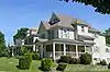 South Park Neighborhood |
June 18, 2008 (#07001253) |
Roughly bounded by Hickman St., an alley east of Kentucky St., the rear of properties facing Highland St., and French Ave. 37°59′16″N 84°10′56″W |
Winchester | |
| 55 | Springhill | 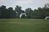 Springhill |
February 17, 1978 (#78001309) |
North of Winchester on Colby Rd. 38°00′30″N 84°17′11″W |
Winchester | |
| 56 | Stipp House | November 20, 1980 (#80001501) |
Van Meter Rd. 38°03′41″N 84°14′58″W |
Winchester | ||
| 57 | F. Taylor Mill | November 20, 1980 (#80001502) |
Address Restricted |
Winchester | ||
| 58 | William Taylor House | August 1, 1979 (#79003600) |
Lower Howard's Creek 37°56′16″N 84°15′52″W |
Becknerville | ||
| 59 | Stanley F. Tebbs House | 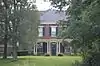 Stanley F. Tebbs House |
August 1, 1979 (#79003579) |
Todd's Rd. 38°00′02″N 84°17′04″W |
Pine Grove | |
| 60 | Thomson Neighborhood District | 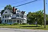 Thomson Neighborhood District |
January 17, 1992 (#91001925) |
Roughly bounded by S. Main St., Moundale Ave., Boone Ave., S. Maple St. and W. Hickman St. 37°59′16″N 84°10′56″W |
Winchester | |
| 61 | Upper Reaches of Boone Creek Rural Historic District | 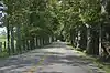 Upper Reaches of Boone Creek Rural Historic District |
November 27, 2009 (#09000569) |
Upper Boone Creek vicinity 38°00′14″N 84°18′14″W |
Winchester | |
| 62 | Van Meter Distillery | 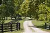 Van Meter Distillery |
August 1, 1979 (#79003599) |
Van Meter Rd. 38°02′16″N 84°12′52″W |
Winchester | |
| 63 | Victory Heights Elementary School | 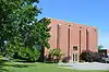 Victory Heights Elementary School |
August 4, 2004 (#04000796) |
160 Maryland Ave. 38°00′05″N 84°11′39″W |
Winchester | |
| 64 | Vinewood | 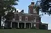 Vinewood |
August 12, 1977 (#77000610) |
4 miles northeast of Winchester on U.S. Route 60 38°02′07″N 84°07′35″W |
Winchester | |
| 65 | Wade Farmstead | 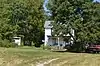 Wade Farmstead |
August 1, 1979 (#79003601) |
Donaldson Rd. 38°06′26″N 84°05′07″W |
Winchester | |
| 66 | Winchester Downtown Commercial District | 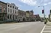 Winchester Downtown Commercial District |
April 28, 1982 (#82002681) |
Roughly bounded by railroad tracks, KY 627, and Maple and Highland Sts. 37°59′34″N 84°10′38″W |
Winchester | |
| 67 | Woodford-Fishback-Venable Farm | 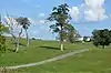 Woodford-Fishback-Venable Farm |
July 8, 2008 (#08000655) |
5696 Combs Ferry Rd. 37°56′21″N 84°17′05″W |
Winchester | |
| 68 | Wright-Evans House | March 5, 2019 (#100003474) |
3800 Pretty Run Rd. 38°05′41″N 84°08′05″W |
Winchester vicinity |
See also
| Wikimedia Commons has media related to National Register of Historic Places in Clark County, Kentucky. |
References
- The latitude and longitude information provided in this table was derived originally from the National Register Information System, which has been found to be fairly accurate for about 99% of listings. Some locations in this table may have been corrected to current GPS standards.
- "National Register of Historic Places: Weekly List Actions". National Park Service, United States Department of the Interior. Retrieved on February 5, 2021.
- Numbers represent an alphabetical ordering by significant words. Various colorings, defined here, differentiate National Historic Landmarks and historic districts from other NRHP buildings, structures, sites or objects.
- The eight-digit number below each date is the number assigned to each location in the National Register Information System database, which can be viewed by clicking the number.
- Linney, W.M. Report on the Geological Survey of Kentucky. Frankfort: Geological Survey of Kentucky, 1884, 40-41.
| Topics | |
|---|---|
| Lists by state |
|
| Lists by insular areas | |
| Lists by associated state | |
| Other areas | |
| Related | |
| |
Municipalities and communities of Clark County, Kentucky, United States | ||
|---|---|---|
| City | Location of Clark County, Kentucky | |
| Unincorporated communities | ||
| ||
This article is issued from Wikipedia. The text is licensed under Creative Commons - Attribution - Sharealike. Additional terms may apply for the media files.