National Register of Historic Places listings in Laurel County, Kentucky
This is a list of the National Register of Historic Places listings in Laurel County, Kentucky.
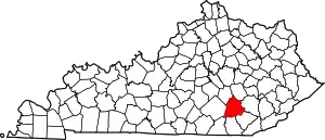
Location of Laurel County in Kentucky
It is intended to be a complete list of the properties on the National Register of Historic Places in Laurel County, Kentucky, United States. The locations of National Register properties for which the latitude and longitude coordinates are included below, may be seen in a map.[1]
There are 9 properties listed on the National Register in the county.
- This National Park Service list is complete through NPS recent listings posted January 29, 2021.[2]
Current listings
| [3] | Name on the Register | Image | Date listed[4] | Location | City or town | Description |
|---|---|---|---|---|---|---|
| 1 | Sue Bennett Memorial School Building | 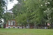 Sue Bennett Memorial School Building |
September 11, 1979 (#79001017) |
College St. 37°07′30″N 84°05′20″W |
London | |
| 2 | Federal Building-Courthouse | .jpg.webp) Federal Building-Courthouse |
August 19, 1974 (#74000889) |
Main and 3rd Sts. 37°07′39″N 84°04′57″W |
London | |
| 3 | First Evangelical Reformed Church | 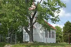 First Evangelical Reformed Church |
April 22, 1980 (#80001648) |
Kentucky Route 80 37°09′25″N 84°11′38″W |
Bernstadt | |
| 4 | London Downtown Historic District |  London Downtown Historic District |
November 10, 2011 (#11000793) |
Main St. between W. 6th and W. 5th Sts. 37°07′45″N 84°05′02″W |
London | |
| 5 | London Tuberculosis Hospital |  London Tuberculosis Hospital |
August 4, 2016 (#16000503) |
85 State Police Rd. 37°08′43″N 84°06′19″W |
London | |
| 6 | Pennington Infirmary | 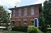 Pennington Infirmary |
June 11, 1987 (#87000900) |
411 Main St. 37°07′50″N 84°05′08″W |
London | |
| 7 | Poynter Building | 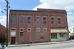 Poynter Building |
August 8, 1985 (#85001745) |
Main St. 37°07′44″N 84°05′04″W |
London | |
| 8 | Harland Sanders Café | 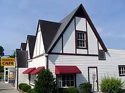 Harland Sanders Café |
August 7, 1990 (#90001169) |
Junction of W. Dixie Highway and E. Dixie Ave. 36°57′35″N 84°05′39″W |
North Corbin | |
| 9 | Wildcat Battlefield Site | June 28, 1979 (#79001018) |
13.4 miles north of London off U.S. Route 25 37°15′43″N 84°12′01″W |
London | Marks the site of the Battle of Camp Wildcat |
See also
| Wikimedia Commons has media related to National Register of Historic Places in Laurel County, Kentucky. |
References
- The latitude and longitude information provided in this table was derived originally from the National Register Information System, which has been found to be fairly accurate for about 99% of listings. Some locations in this table may have been corrected to current GPS standards.
- "National Register of Historic Places: Weekly List Actions". National Park Service, United States Department of the Interior. Retrieved on January 29, 2021.
- Numbers represent an alphabetical ordering by significant words. Various colorings, defined here, differentiate National Historic Landmarks and historic districts from other NRHP buildings, structures, sites or objects.
- The eight-digit number below each date is the number assigned to each location in the National Register Information System database, which can be viewed by clicking the number.
| Topics | |
|---|---|
| Lists by state |
|
| Lists by insular areas | |
| Lists by associated state | |
| Other areas | |
| Related | |
| |
Municipalities and communities of Laurel County, Kentucky, United States | ||
|---|---|---|
| City | Location of Laurel County, Kentucky | |
| CDPs | ||
| Unincorporated communities | ||
| Footnotes | ‡This populated place also has portions in an adjacent county | |
| ||
This article is issued from Wikipedia. The text is licensed under Creative Commons - Attribution - Sharealike. Additional terms may apply for the media files.