National Register of Historic Places listings in Bath County, Kentucky
This is a list of the National Register of Historic Places listings in Bath County, Kentucky.
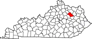
Location of Bath County in Kentucky
It is intended to be a complete list of the properties on the National Register of Historic Places in Bath County, Kentucky, United States. The locations of National Register properties for which the latitude and longitude coordinates are included below, may be seen in a map.[1]
There are 9 properties listed on the National Register in the county.
- This National Park Service list is complete through NPS recent listings posted January 29, 2021.[2]
Current listings
| [3] | Name on the Register | Image | Date listed[4] | Location | City or town | Description |
|---|---|---|---|---|---|---|
| 1 | Bourbon Iron Works | 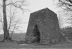 Bourbon Iron Works |
September 1, 1976 (#76000844) |
2.6 miles (4.2 km) south of Owingsville on Kentucky Route 36 38°06′51″N 83°44′53″W |
Owingsville | |
| 2 | Confederate Monument in Owingsville | 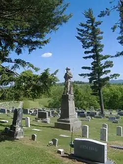 Confederate Monument in Owingsville |
July 17, 1997 (#97000718) |
East of Owingsville, 1.5 miles (2.4 km) south of U.S. Route 60 38°08′32″N 83°45′34″W |
Owingsville | |
| 3 | Myrtle Hill | October 29, 1982 (#82001550) |
South of Owingsville off U.S. Route 64 38°07′21″N 83°47′03″W |
Owingsville | ||
| 4 | J.J. Nesbitt House | 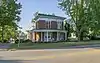 J.J. Nesbitt House |
August 5, 2010 (#10000532) |
233 W. Main St. 38°08′39″N 83°46′04″W |
Owingsville | |
| 5 | Col. Thomas Deye Owings House | 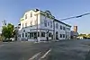 Col. Thomas Deye Owings House |
January 9, 1978 (#78001297) |
Main St. and Courthouse Sq. 38°08′40″N 83°45′54″W |
Owingsville | |
| 6 | Owingsville Commercial District and Courthouse Square | 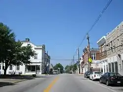 Owingsville Commercial District and Courthouse Square |
November 20, 1978 (#78001298) |
Main and Court Sts.; also 122 E. Main St. 38°08′41″N 83°45′52″W |
Owingsville | 122 E. Main represents a boundary increase of August 1, 1985 |
| 7 | Ramey Mound | February 12, 1998 (#98000089) |
0.5 miles (0.80 km) north of Sharpsburg[5] 38°12′27″N 83°55′51″W |
Sharpsburg | ||
| 8 | "Raccoon" John Smith House | 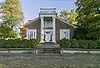 "Raccoon" John Smith House |
August 6, 2012 (#12000445) |
250 W. Main St.[6] 38°08′39″N 83°46′07″W |
Owingsville | |
| 9 | Springfield Presbyterian Church | April 26, 1979 (#79000959) |
South of Sharpsburg on Springfield Rd. 38°08′56″N 83°54′13″W |
Sharpsburg |
See also
| Wikimedia Commons has media related to National Register of Historic Places in Bath County, Kentucky. |
References
- The latitude and longitude information provided in this table was derived originally from the National Register Information System, which has been found to be fairly accurate for about 99% of listings. Some locations in this table may have been corrected to current GPS standards.
- "National Register of Historic Places: Weekly List Actions". National Park Service, United States Department of the Interior. Retrieved on January 29, 2021.
- Numbers represent an alphabetical ordering by significant words. Various colorings, defined here, differentiate National Historic Landmarks and historic districts from other NRHP buildings, structures, sites or objects.
- The eight-digit number below each date is the number assigned to each location in the National Register Information System database, which can be viewed by clicking the number.
- Funkhouser, W.D., and W.S. Webb. Archaeological Survey of Kentucky. University of Kentucky Reports in Archaeology and Anthropology 2. Lexington: U of KY Department of Anthropology and Archaeology, 1932, 21.
- Polsgrove, Bob, et al. National Register of Historic Places Inventory/Nomination: "Raccoon" John Smith House. National Park Service, 2012-02, 18.
| Topics | |
|---|---|
| Lists by state |
|
| Lists by insular areas | |
| Lists by associated state | |
| Other areas | |
| Related | |
| |
Municipalities and communities of Bath County, Kentucky, United States | ||
|---|---|---|
| Cities | Location of Bath County, Kentucky | |
| Unincorporated communities | ||
| ||
This article is issued from Wikipedia. The text is licensed under Creative Commons - Attribution - Sharealike. Additional terms may apply for the media files.