National Register of Historic Places listings in Marshall County, Kentucky
This is a list of the National Register of Historic Places listings in Marshall County, Kentucky.
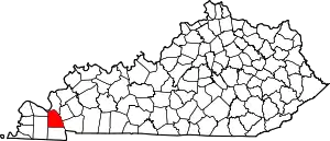
Location of Marshall County in Kentucky
This is intended to be a complete list of the properties on the National Register of Historic Places in Marshall County, Kentucky, United States. The locations of National Register properties for which the latitude and longitude coordinates are included below, may be seen in a map.[1]
There are 6 properties listed on the National Register in the county.
- This National Park Service list is complete through NPS recent listings posted February 5, 2021.[2]
Current listings
| [3] | Name on the Register | Image | Date listed[4] | Location | City or town | Description |
|---|---|---|---|---|---|---|
| 1 | Archeological Site No. 15 Ml 109 |  Archeological Site No. 15 Ml 109 |
January 27, 1983 (#83002813) |
Ridgetop above the Middle Fork of Clarks River[5]:35, 632 36°52′50″N 88°25′10″W |
Benton | Also known as the "Chambers Site"[5]:630 |
| 2 | Cherokee State Park |  Cherokee State Park |
January 9, 2009 (#08001120) |
542 Kenlake Rd. 36°45′40″N 88°08′33″W |
Hardin | |
| 3 | Kentucky Hydroelectric Project | 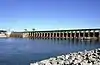 Kentucky Hydroelectric Project |
August 11, 2017 (#100001456) |
640 Kentucky Dam Rd. 37°00′40″N 88°16′19″W |
Grand Rivers | Extends into Livingston County |
| 4 | James R. Lemon House | 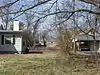 James R. Lemon House |
August 28, 1975 (#75000802) |
1309 Main St. 36°51′19″N 88°21′02″W |
Benton | |
| 5 | Oak Hill | 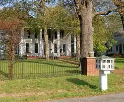 Oak Hill |
December 31, 1974 (#74000894) |
26 Aspen St. 37°01′50″N 88°20′52″W |
Calvert City | |
| 6 | Stilley House | 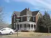 Stilley House |
September 4, 1986 (#86002195) |
925 Birch St. 36°51′33″N 88°20′49″W |
Benton |
See also
| Wikimedia Commons has media related to National Register of Historic Places in Marshall County, Kentucky. |
References
- The latitude and longitude information provided in this table was derived originally from the National Register Information System, which has been found to be fairly accurate for about 99% of listings. Some locations in this table may have been corrected to current GPS standards.
- "National Register of Historic Places: Weekly List Actions". National Park Service, United States Department of the Interior. Retrieved on February 5, 2021.
- Numbers represent an alphabetical ordering by significant words. Various colorings, defined here, differentiate National Historic Landmarks and historic districts from other NRHP buildings, structures, sites or objects.
- The eight-digit number below each date is the number assigned to each location in the National Register Information System database, which can be viewed by clicking the number.
- Pollack, David, ed. The Archaeology of Kentucky: An Update. Frankfort: Kentucky Heritage Council, 2008.
| Topics | |
|---|---|
| Lists by state |
|
| Lists by insular areas | |
| Lists by associated state | |
| Other areas | |
| Related | |
| |
Municipalities and communities of Marshall County, Kentucky, United States | ||
|---|---|---|
| Cities | Location of Marshall County, Kentucky | |
| CDP | ||
| Other unincorporated communities | ||
| Ghost town | ||
| ||
This article is issued from Wikipedia. The text is licensed under Creative Commons - Attribution - Sharealike. Additional terms may apply for the media files.