National Register of Historic Places listings in Montgomery County, Kentucky
This is a list of the National Register of Historic Places listings in Montgomery County, Kentucky.

Location of Montgomery County in Kentucky
This is intended to be a complete list of the properties and districts on the National Register of Historic Places in Montgomery County, Kentucky, United States. The locations of National Register properties and districts for which the latitude and longitude coordinates are included below, may be seen in a map.[1]
There are 18 properties and districts listed on the National Register in the county.
- This National Park Service list is complete through NPS recent listings posted January 29, 2021.[2]
Current listings
| [3] | Name on the Register | Image | Date listed[4] | Location | City or town | Description |
|---|---|---|---|---|---|---|
| 1 | Bondurant House | June 23, 1983 (#83002835) |
Off U.S. Route 60 38°05′03″N 83°53′50″W |
Mount Sterling | ||
| 2 | Chesapeake and Ohio Railroad Passenger and Baggage Depots | 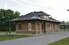 Chesapeake and Ohio Railroad Passenger and Baggage Depots |
April 23, 1991 (#91000431) |
North of C&O railroad tracks between S. Maysville and S. Bank Sts. 38°03′16″N 83°56′30″W |
Mount Sterling | |
| 3 | William Chiles House |  William Chiles House |
April 23, 1991 (#91000430) |
Off Richmond Rd. south of U.S. Route 60 38°03′10″N 83°56′59″W |
Mount Sterling | |
| 4 | Church of the Ascension |  Church of the Ascension |
July 10, 1979 (#79001025) |
High and Broadway Sts. 38°03′25″N 83°56′37″W |
Mount Sterling | |
| 5 | Confederate Monument of Mt. Sterling |  Confederate Monument of Mt. Sterling |
July 17, 1997 (#97000675) |
Machpelan Cemetery, 1.5 miles east of the junction of U.S. Route 460 and Kentucky Route 713 38°03′23″N 83°55′55″W |
Mount Sterling | |
| 6 | East Mount Sterling Historic District | 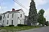 East Mount Sterling Historic District |
April 23, 1991 (#91000433) |
Roughly Harrison Ave. and N. Queen St. between E. High St. and an alley north of Strother St. 38°03′36″N 83°56′26″W |
Mount Sterling | |
| 7 | W.T. Fitzpatrick House |  W.T. Fitzpatrick House |
April 23, 1991 (#91000429) |
Apperson Heights east of S. Bank St. 38°03′11″N 83°56′28″W |
Mount Sterling | |
| 8 | Gaitskill Mound Archeological Site | 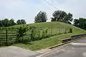 Gaitskill Mound Archeological Site |
October 21, 1975 (#75000807) |
Off Indian Mound Dr.[5] 38°04′21″N 83°57′02″W |
Mount Sterling | |
| 9 | Miss Emma Hicks Bungalow | 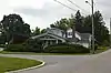 Miss Emma Hicks Bungalow |
April 23, 1991 (#91000428) |
10 White Ave. 38°03′20″N 83°57′03″W |
Mount Sterling | |
| 10 | KEAS Tabernacle Christian Methodist Episcopal Church | 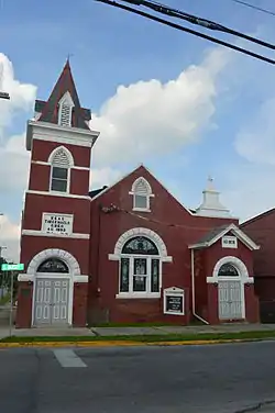 KEAS Tabernacle Christian Methodist Episcopal Church |
May 26, 1983 (#83002836) |
101 S. Queen St. 38°03′21″N 83°56′18″W |
Mount Sterling | |
| 11 | Machpelah Cemetery |  Machpelah Cemetery |
April 23, 1991 (#91000427) |
E. Main St. at eastern city limits 38°03′30″N 83°55′55″W |
Mount Sterling | |
| 12 | Methodist Episcopal Church South | 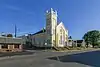 Methodist Episcopal Church South |
April 23, 1991 (#91000426) |
Junction of E. Main and N. Wilson Sts. 38°03′25″N 83°56′26″W |
Mount Sterling | |
| 13 | Monarch Milling Company | 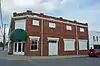 Monarch Milling Company |
April 23, 1991 (#91000425) |
Junction of S. Maysville and E. Locust 38°03′18″N 83°56′29″W |
Mount Sterling | |
| 14 | Ralph Morgan Stone House | April 10, 1980 (#80001658) |
East of Mount Sterling on Harper's Ridge Rd. 38°02′08″N 83°49′44″W |
Mount Sterling | ||
| 15 | Mount Sterling Commercial District |  Mount Sterling Commercial District |
October 3, 1980 (#80001659) |
U.S. Route 60 and Kentucky Route 11 38°03′22″N 83°56′28″W |
Mount Sterling | |
| 16 | Northwest Residential District | 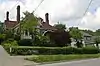 Northwest Residential District |
September 14, 1989 (#89001422) |
Roughly Kentucky Route 1991, N. Maysville St., W. Main St., Samuels Ave., High St., Antwerp Ave., Holt, Sycamore, and Sterling 38°03′34″N 83°56′47″W |
Mount Sterling | |
| 17 | Enoch Smith House | 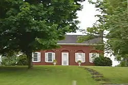 Enoch Smith House |
August 19, 1980 (#80001660) |
Kentucky Route 1 38°03′10″N 83°57′41″W |
Mount Sterling | |
| 18 | Wright-Greene Mound Complex | February 12, 1998 (#98000093) |
Address Restricted |
Mount Sterling |
See also
| Wikimedia Commons has media related to National Register of Historic Places in Montgomery County, Kentucky. |
References
- The latitude and longitude information provided in this table was derived originally from the National Register Information System, which has been found to be fairly accurate for about 99% of listings. Some locations in this table may have been corrected to current GPS standards.
- "National Register of Historic Places: Weekly List Actions". National Park Service, United States Department of the Interior. Retrieved on January 29, 2021.
- Numbers represent an alphabetical ordering by significant words. Various colorings, defined here, differentiate National Historic Landmarks and historic districts from other NRHP buildings, structures, sites or objects.
- The eight-digit number below each date is the number assigned to each location in the National Register Information System database, which can be viewed by clicking the number.
- Kentucky Heritage Council. "The Gaitskill Mound", 1975. Accessed via the Historical Marker Database, 2014-06-12.
| Topics | |
|---|---|
| Lists by state |
|
| Lists by insular areas | |
| Lists by associated state | |
| Other areas | |
| Related | |
| |
Municipalities and communities of Montgomery County, Kentucky, United States | ||
|---|---|---|
| Cities | Location of Montgomery County, Kentucky | |
| Unincorporated community | ||
| ||
This article is issued from Wikipedia. The text is licensed under Creative Commons - Attribution - Sharealike. Additional terms may apply for the media files.