National Register of Historic Places listings in Pulaski County, Kentucky
This is a list of the National Register of Historic Places listings in Pulaski County, Kentucky.

Location of Pulaski County in Kentucky
This is intended to be a complete list of the properties and districts on the National Register of Historic Places in Pulaski County, Kentucky, United States. The locations of National Register properties and districts for which the latitude and longitude coordinates are included below, may be seen in a map.[1]
There are 39 properties and districts listed on the National Register in the county, 1 of which is a National Historic Landmark. Another property was once listed but has been removed.
- This National Park Service list is complete through NPS recent listings posted February 5, 2021.[2]
Current listings
| [3] | Name on the Register | Image | Date listed[4] | Location | City or town | Description |
|---|---|---|---|---|---|---|
| 1 | Battle of Dutton's Hill Monument |  Battle of Dutton's Hill Monument |
July 17, 1997 (#97000670) |
Old Crab Orchard Rd., 1 mile north of the junction of Kentucky Routes 39 and 80 37°07′03″N 84°36′14″W |
Somerset | |
| 2 | Battle of Mill Springs Historic Areas | 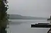 Battle of Mill Springs Historic Areas |
February 18, 1993 (#93000001) |
Three discontiguous areas: one south of Nancy, one in Mill Springs, and one to the north across the Cumberland River 37°00′19″N 84°45′28″W |
Nancy | |
| 3 | Beatty-Newell House |  Beatty-Newell House |
August 16, 1985 (#85001834) |
Off Kentucky Route 90 36°59′09″N 84°37′04″W |
Bronston | |
| 4 | Boland House |  Boland House |
August 14, 1984 (#84001939) |
Lakeshore Dr. 36°59′24″N 84°36′19″W |
Burnside | |
| 5 | Buck-Mercer House | August 14, 1984 (#84001941) |
Waynesburg Rd. 37°14′02″N 84°35′04″W |
Somerset | ||
| 6 | Burnside Historic District | August 14, 1984 (#84001944) |
Lakeshore Dr. and French Ave. 36°59′12″N 84°36′11″W |
Burnside | ||
| 7 | Burnside Lodge | 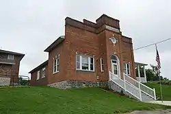 Burnside Lodge |
August 14, 1984 (#84001946) |
Off U.S. Route 27 36°59′13″N 84°36′03″W |
Burnside | A Masonic lodge building |
| 8 | Burnside Methodist Church | 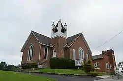 Burnside Methodist Church |
August 16, 1985 (#85001836) |
Off U.S. Route 27 36°59′13″N 84°36′03″W |
Burnside | |
| 9 | Confederate Mass Grave Monument in Nancy | 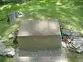 Confederate Mass Grave Monument in Nancy |
July 17, 1997 (#97000671) |
Zollicoffer Park Cemetery, 0.3 miles south of the junction of Kentucky Routes 235 and 761 37°03′20″N 84°44′22″W |
Nancy | |
| 10 | Crawford House | August 14, 1984 (#84001952) |
121 Maple St. 37°05′40″N 84°36′15″W |
Somerset | Largest Victorian style house in the county, from c.1890; apparently moved or destroyed. | |
| 11 | A. Jackson Crawford Building | 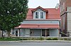 A. Jackson Crawford Building |
August 18, 1980 (#80001665) |
207 S. Main St. 37°05′25″N 84°36′15″W |
Somerset | |
| 12 | Dabney Post Office | August 14, 1984 (#84001954) |
Kentucky Route 39 37°10′57″N 84°33′00″W |
Dabney | ||
| 13 | Evans House | August 16, 1985 (#85001837) |
Kentucky Route 461 37°12′10″N 84°27′40″W |
Shopville | ||
| 14 | William Fox House | 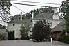 William Fox House |
July 31, 1978 (#78001391) |
206 W. Columbia St. 37°05′34″N 84°36′26″W |
Somerset | |
| 15 | Gover-Hardin House | 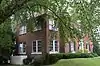 Gover-Hardin House |
July 11, 2007 (#07000674) |
307 W. Mt. Vernon St. 37°05′29″N 84°36′28″W |
Somerset | |
| 16 | Harvey's Hill Historic District | 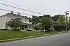 Harvey's Hill Historic District |
August 14, 1984 (#84001958) |
401-527 N. Main St., and 402-526 N. Main St. 37°05′49″N 84°36′24″W |
Somerset | |
| 17 | Hotel Beecher | 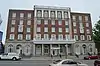 Hotel Beecher |
August 14, 1984 (#84001960) |
203 S. Main St. 37°05′26″N 84°36′16″W |
Somerset | |
| 18 | James-Hansford House | August 16, 1985 (#85001838) |
On Kentucky Route 80 37°09′29″N 84°28′40″W |
Shopville | ||
| 19 | James-Owens House | August 16, 1985 (#85001839) |
Off Kentucky Route 80 37°09′05″N 84°28′45″W |
Shopville | ||
| 20 | Mill Springs National Cemetery | 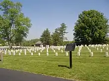 Mill Springs National Cemetery |
May 29, 1998 (#98000592) |
9044 W. Kentucky Route 80 37°04′06″N 84°44′14″W |
Nancy | |
| 21 | Morrow House | 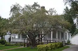 Morrow House |
August 14, 1984 (#84001962) |
208 E. Oak St. 37°05′45″N 84°36′13″W |
Somerset | |
| 22 | North Main Street Historic District | 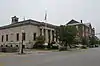 North Main Street Historic District |
August 14, 1984 (#84001964) |
N. Main and Columbia Sts. 37°05′26″N 84°36′16″W |
Somerset | |
| 23 | Parker House | 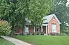 Parker House |
August 14, 1984 (#84001970) |
206 N. Vine St. 37°05′35″N 84°36′24″W |
Somerset | |
| 24 | Payne House | August 16, 1985 (#85001840) |
Off Kentucky Route 1247 37°16′51″N 84°39′35″W |
Eubank | ||
| 25 | Payne Mill | August 14, 1984 (#84001968) |
Off Kentucky Route 1247 37°16′51″N 84°39′35″W |
Eubank | ||
| 26 | Dr. John Milton Perkins House | 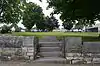 Dr. John Milton Perkins House |
August 10, 1978 (#78001392) |
109 N. Main St. 37°05′36″N 84°36′18″W |
Somerset | |
| 27 | Robinson Mill | August 14, 1984 (#84001971) |
S. Main St. 37°04′55″N 84°36′41″W |
Somerset | ||
| 28 | Dill Scott House | 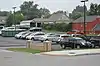 Dill Scott House |
August 14, 1984 (#84001972) |
200 N. Main St. 37°05′40″N 84°36′21″W |
Somerset | |
| 29 | Smith House | 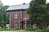 Smith House |
August 14, 1984 (#84001974) |
200 N. College St. 37°05′41″N 84°36′08″W |
Somerset | |
| 30 | Beecher Smith House | 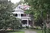 Beecher Smith House |
August 14, 1984 (#84001973) |
405 College St. 37°05′53″N 84°36′10″W |
Somerset | |
| 31 | Somerset Armory | 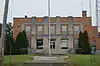 Somerset Armory |
September 6, 2002 (#02000926) |
109 Grand Ave. 37°05′37″N 84°35′49″W |
Somerset | |
| 32 | Somerset City School and Carnegie Library | 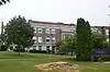 Somerset City School and Carnegie Library |
July 7, 1978 (#78001393) |
300 College St. 37°05′45″N 84°36′06″W |
Somerset | |
| 33 | Somerset Downtown Commercial District | 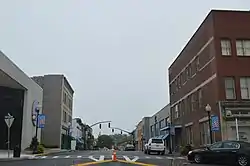 Somerset Downtown Commercial District |
August 27, 1982 (#82002742) |
108-236 and 201-223 E. Mt. Vernon St. 37°05′32″N 84°36′15″W |
Somerset | |
| 34 | South Courthouse Square Historic District | 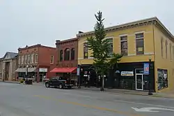 South Courthouse Square Historic District |
August 14, 1984 (#84001975) |
Public Sq., Zachary Way, W. Mt. Vernon, S. Main, and S. Maple Sts. 37°05′31″N 84°36′17″W |
Somerset | |
| 35 | US Post Office-Bronston | 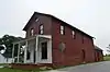 US Post Office-Bronston |
August 16, 1985 (#85001835) |
Kentucky Route 790 36°59′09″N 84°37′09″W |
Bronston | |
| 36 | Waddle-Prather House | 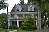 Waddle-Prather House |
August 14, 1984 (#84001976) |
311 N. College St. 37°05′50″N 84°36′09″W |
Somerset | |
| 37 | West Columbia Street District | 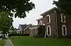 West Columbia Street District |
August 14, 1984 (#84001977) |
201-303 W. Columbia St. 37°05′32″N 84°36′24″W |
Somerset | |
| 38 | Withers House | August 14, 1984 (#84001978) |
116 Maple St. 37°05′37″N 84°36′15″W |
Somerset | ||
| 39 | Gen. Felix K. Zollicoffer Monument | 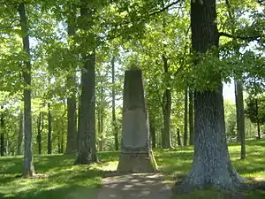 Gen. Felix K. Zollicoffer Monument |
July 17, 1997 (#97000672) |
Zollicoffer Park Cemetery, 0.3 miles south of the junction of Kentucky Routes 235 and 761 37°03′20″N 84°44′22″W |
Nancy |
Former listing
| [3] | Name on the Register | Image | Date listed | Date removed | Location | City or town | Summary |
|---|---|---|---|---|---|---|---|
| 1 | City Hall | August 14, 1984 (#84001949) | July 25, 2012 | 400 E. Mt. Vernon St. 37°05′36″N 84°35′40″W |
Somerset |
See also
| Wikimedia Commons has media related to National Register of Historic Places in Pulaski County, Kentucky. |
References
- The latitude and longitude information provided in this table was derived originally from the National Register Information System, which has been found to be fairly accurate for about 99% of listings. Some locations in this table may have been corrected to current GPS standards.
- "National Register of Historic Places: Weekly List Actions". National Park Service, United States Department of the Interior. Retrieved on February 5, 2021.
- Numbers represent an alphabetical ordering by significant words. Various colorings, defined here, differentiate National Historic Landmarks and historic districts from other NRHP buildings, structures, sites or objects.
- The eight-digit number below each date is the number assigned to each location in the National Register Information System database, which can be viewed by clicking the number.
| Topics | |
|---|---|
| Lists by state |
|
| Lists by insular areas | |
| Lists by associated state | |
| Other areas | |
| Related | |
| |
Municipalities and communities of Pulaski County, Kentucky, United States | ||
|---|---|---|
| Cities | Location of Pulaski County, Kentucky | |
| Unincorporated communities | ||
| Ghost towns | ||
| Footnotes | ‡This populated place also has portions in an adjacent county | |
| ||
This article is issued from Wikipedia. The text is licensed under Creative Commons - Attribution - Sharealike. Additional terms may apply for the media files.