National Register of Historic Places listings in Trigg County, Kentucky
This is a list of the National Register of Historic Places listings in Trigg County, Kentucky.

Location of Trigg County in Kentucky
It is intended to be a complete list of the properties on the National Register of Historic Places in Trigg County, Kentucky, United States. The locations of National Register properties for which the latitude and longitude coordinates are included below, may be seen in a map.[1]
There are 8 properties listed on the National Register in the county.
- This National Park Service list is complete through NPS recent listings posted February 5, 2021.[2]
Current listings
| [3] | Name on the Register | Image | Date listed[4] | Location | City or town | Description |
|---|---|---|---|---|---|---|
| 1 | Brick Inn | 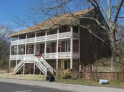 Brick Inn |
April 10, 1980 (#80001672) |
Off Kentucky Route 80 36°48′06″N 87°58′05″W |
Canton | |
| 2 | Cadiz Downtown Historic District | 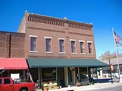 Cadiz Downtown Historic District |
November 14, 1988 (#88002606) |
Roughly Main St. from Scott to Franklin Sts. 36°51′44″N 87°50′13″W |
Cadiz | |
| 3 | Cadiz Main Street Residential District | 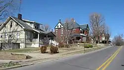 Cadiz Main Street Residential District |
May 16, 1989 (#89000384) |
Main St. between Line St. and Scott St. 36°51′53″N 87°49′59″W |
Cadiz | |
| 4 | Cadiz Masonic Lodge No. 121 F. and A.M. | 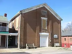 Cadiz Masonic Lodge No. 121 F. and A.M. |
April 17, 1979 (#79001032) |
Jefferson and Monroe Sts. 36°51′45″N 87°50′16″W |
Cadiz | |
| 5 | Center Furnace | May 12, 1977 (#77000652) |
Between Honker and Hematite Lakes, Land Between the Lakes National Recreation Area[5] 36°54′01″N 88°02′19″W |
Golden Pond | ||
| 6 | Confederate Monument of Cadiz | 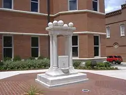 Confederate Monument of Cadiz |
July 17, 1997 (#97000667) |
Courthouse Lawn, 0.5 miles east of the junction of Kentucky Routes 139 and 1175 36°51′42″N 87°50′16″W |
Cadiz | |
| 7 | Thomas Dawson House | December 1, 1980 (#80001671) |
South of Cadiz 36°43′16″N 87°41′10″W |
Cadiz | ||
| 8 | John McCaughan House | January 8, 1987 (#87000212) |
Kentucky Route 276 36°54′07″N 87°45′22″W |
Cadiz |
See also
| Wikimedia Commons has media related to National Register of Historic Places in Trigg County, Kentucky. |
References
- The latitude and longitude information provided in this table was derived originally from the National Register Information System, which has been found to be fairly accurate for about 99% of listings. Some locations in this table may have been corrected to current GPS standards.
- "National Register of Historic Places: Weekly List Actions". National Park Service, United States Department of the Interior. Retrieved on February 5, 2021.
- Numbers represent an alphabetical ordering by significant words. Various colorings, defined here, differentiate National Historic Landmarks and historic districts from other NRHP buildings, structures, sites or objects.
- The eight-digit number below each date is the number assigned to each location in the National Register Information System database, which can be viewed by clicking the number.
- U.S. Geological Survey Geographic Names Information System: Center Furnace
| Topics | |
|---|---|
| Lists by state |
|
| Lists by insular areas | |
| Lists by associated state | |
| Other areas | |
| Related | |
| |
Municipalities and communities of Trigg County, Kentucky, United States | ||
|---|---|---|
| City | Location of Trigg County, Kentucky | |
| CDP | ||
| Other unincorporated community | ||
| Ghost town | ||
| Footnotes | ‡This populated place also has portions in an adjacent county or counties | |
| ||
This article is issued from Wikipedia. The text is licensed under Creative Commons - Attribution - Sharealike. Additional terms may apply for the media files.