National Register of Historic Places listings in Caldwell County, Kentucky
This is a list of the National Register of Historic Places listings in Caldwell County, Kentucky.
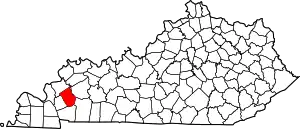
Location of Caldwell County in Kentucky
It is intended to be a complete list of the properties and districts on the National Register of Historic Places in Caldwell County, Kentucky, United States. The locations of National Register properties and districts for which the latitude and longitude coordinates are included below, may be seen in a map.[1]
There are 10 properties and districts listed on the National Register in the county. Another property was once listed but has been removed.
- This National Park Service list is complete through NPS recent listings posted February 5, 2021.[2]
Current listings
| [3] | Name on the Register | Image | Date listed[4] | Location | City or town | Description |
|---|---|---|---|---|---|---|
| 1 | Adsmore | 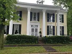 Adsmore |
October 25, 1973 (#73000793) |
304 N. Jefferson St. 37°06′37″N 87°52′49″W |
Princeton | |
| 2 | Champion-Shepherdson House | 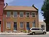 Champion-Shepherdson House |
December 28, 1978 (#78003411) |
115 E. Main St. 37°06′31″N 87°52′52″W |
Princeton | |
| 3 | Confederate Soldier Monument in Caldwell | 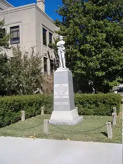 Confederate Soldier Monument in Caldwell |
July 17, 1997 (#97000712) |
Junction of Kentucky Route 91 and N. Jefferson St. 37°06′32″N 87°52′55″W |
Princeton | |
| 4 | Fredonia Cumberland Presbyterian Church | 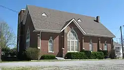 Fredonia Cumberland Presbyterian Church |
August 8, 1985 (#85001746) |
U.S. Route 641 37°12′37″N 88°03′32″W |
Fredonia | |
| 5 | Halleck's Chapel and Halleck's School | 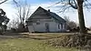 Halleck's Chapel and Halleck's School |
August 2, 2001 (#01000802) |
0.5 miles north of the junction of Kentucky Route 293 and Caldwell Chapel Rd. 37°04′26″N 87°57′43″W |
Princeton | |
| 6 | Knott House | 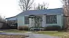 Knott House |
October 13, 1999 (#97001238) |
302 Nichols St. 37°06′06″N 87°52′39″W |
Princeton | |
| 7 | L.B. Overby House | 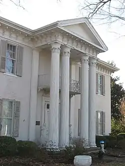 L.B. Overby House |
March 22, 1990 (#90000476) |
317 S. Jefferson St. 37°06′19″N 87°53′02″W |
Princeton | |
| 8 | William S. Powell House | 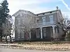 William S. Powell House |
May 26, 1995 (#95000641) |
501 Washington St. 37°06′34″N 87°53′16″W |
Princeton | |
| 9 | Princeton Downtown Commercial District |  Princeton Downtown Commercial District |
September 19, 1988 (#88001017) |
Roughly along Main St., E. and W. Court Sq. Sts. 37°06′31″N 87°52′56″W |
Princeton | |
| 9 | State Road-Hill Cemetery Segment | June 26, 2020 (#100005312) |
Adjacent to Hill Cemetery at the end of Hill Cemetery Rd. Coordinates missing |
Fredonia vicinity |
Former listing
| [3] | Name on the Register | Image | Date listed | Date removed | Location | City or town | Summary |
|---|---|---|---|---|---|---|---|
| 1 | Flournoy-Henry House | July 19, 1976 (#76000854) | February 5, 1991 | 221 E. Main St. |
Princeton |
See also
| Wikimedia Commons has media related to National Register of Historic Places in Caldwell County, Kentucky. |
References
- The latitude and longitude information provided in this table was derived originally from the National Register Information System, which has been found to be fairly accurate for about 99% of listings. Some locations in this table may have been corrected to current GPS standards.
- "National Register of Historic Places: Weekly List Actions". National Park Service, United States Department of the Interior. Retrieved on February 5, 2021.
- Numbers represent an alphabetical ordering by significant words. Various colorings, defined here, differentiate National Historic Landmarks and historic districts from other NRHP buildings, structures, sites or objects.
- The eight-digit number below each date is the number assigned to each location in the National Register Information System database, which can be viewed by clicking the number.
| Topics | |
|---|---|
| Lists by state |
|
| Lists by insular areas | |
| Lists by associated state | |
| Other areas | |
| Related | |
| |
Municipalities and communities of Caldwell County, Kentucky, United States | ||
|---|---|---|
| Cities | Location of Caldwell County, Kentucky | |
| Unincorporated communities | ||
| Footnotes | ‡This populated place also has portions in an adjacent county or counties | |
| ||
This article is issued from Wikipedia. The text is licensed under Creative Commons - Attribution - Sharealike. Additional terms may apply for the media files.