National Register of Historic Places listings in Taylor County, Kentucky
This is a list of the National Register of Historic Places listings in Taylor County, Kentucky.

Location of Taylor County in Kentucky
This is intended to be a complete list of the properties and districts on the National Register of Historic Places in Taylor County, Kentucky, United States. The locations of National Register properties and districts for which the latitude and longitude coordinates are included below, may be seen in a map.[1]
There are 14 properties and districts listed on the National Register in the county.
- This National Park Service list is complete through NPS recent listings posted January 29, 2021.[2]
Current listings
| [3] | Name on the Register | Image | Date listed[4] | Location | City or town | Description |
|---|---|---|---|---|---|---|
| 1 | Battle of Tebb's Bend Monument | 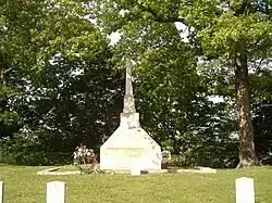 Battle of Tebb's Bend Monument |
July 17, 1997 (#97000668) |
Romine Loop Rd., 0.5 miles north of its junction with Kentucky Route 55 37°13′49″N 85°20′49″W |
Campbellsville | |
| 2 | Battle of Tebbs Bend | 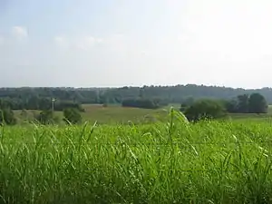 Battle of Tebbs Bend |
July 28, 1999 (#99000900) |
Off Kentucky Route 55, Tebbs Bend Rd. 37°14′19″N 85°21′29″W |
Campbellsville | |
| 3 | James Caldwell House | 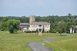 James Caldwell House |
October 3, 2011 (#11000681) |
105 Colonial Dr. 37°15′56″N 85°22′00″W |
Campbellsville | |
| 4 | Campbellsville Historic Commercial District | 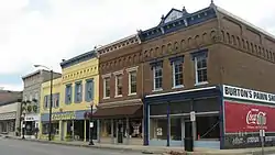 Campbellsville Historic Commercial District |
February 10, 1983 (#83002876) |
Roughly bounded by Columbia Ave., Broadway, 1st, and Hotchkiss Sts., both sides of Central Ave., and railroad tracks 37°20′28″N 85°20′37″W |
Campbellsville | |
| 5 | Campbellsville Residential Historic District | 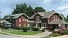 Campbellsville Residential Historic District |
February 7, 2008 (#08000011) |
Roughly bounded by Central Ave. and Duffy, Maple, and Jackson Sts. 37°20′50″N 85°20′43″W |
Campbellsville | |
| 6 | Campbellsville School, Stadium and Athletic Field |  Campbellsville School, Stadium and Athletic Field |
January 4, 2007 (#06001195) |
230 W. Main St. 37°20′15″N 85°20′55″W |
Campbellsville | |
| 7 | John Chandler House | 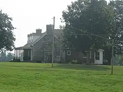 John Chandler House |
January 8, 1987 (#87000184) |
Off Kentucky Route 210 37°21′52″N 85°24′03″W |
Campbellsville | |
| 8 | Clay Hill |  Clay Hill |
October 10, 1975 (#75000835) |
5 miles north of Campbellsville on Kentucky Route 55 37°26′18″N 85°21′40″W |
Campbellsville | |
| 9 | Jonathan Cowherd, Jr., House | 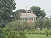 Jonathan Cowherd, Jr., House |
April 11, 1977 (#77000649) |
West of Campbellsville off Kentucky Route 70 37°20′20″N 85°25′22″W |
Campbellsville | |
| 10 | Jacob Hiestand House |  Jacob Hiestand House |
February 10, 1983 (#83002877) |
West of Campbellsville off Kentucky Route 210 37°20′59″N 85°22′31″W |
Campbellsville | |
| 11 | Merchant's Hotel |  Merchant's Hotel |
November 25, 1980 (#80001669) |
102 E. Main St. 37°20′26″N 85°20′41″W |
Campbellsville | |
| 12 | Durham Sanders House |  Durham Sanders House |
July 31, 1996 (#96000792) |
1251 Sanders Rd. 37°25′57″N 85°23′22″W |
Campbellsville | |
| 13 | Isaac Tate Farm | 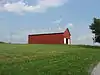 Isaac Tate Farm |
August 4, 2004 (#04000802) |
5 miles south of Campbellsville on Kentucky Route 55 37°15′13″N 85°21′58″W |
Campbellsville | |
| 14 | Taylor County Clerk's Office |  Taylor County Clerk's Office |
December 20, 1977 (#77000650) |
Courthouse Sq. 37°20′29″N 85°20′44″W |
Campbellsville |
See also
| Wikimedia Commons has media related to National Register of Historic Places in Taylor County, Kentucky. |
References
- The latitude and longitude information provided in this table was derived originally from the National Register Information System, which has been found to be fairly accurate for about 99% of listings. Some locations in this table may have been corrected to current GPS standards.
- "National Register of Historic Places: Weekly List Actions". National Park Service, United States Department of the Interior. Retrieved on January 29, 2021.
- Numbers represent an alphabetical ordering by significant words. Various colorings, defined here, differentiate National Historic Landmarks and historic districts from other NRHP buildings, structures, sites or objects.
- The eight-digit number below each date is the number assigned to each location in the National Register Information System database, which can be viewed by clicking the number.
| Topics | |
|---|---|
| Lists by state |
|
| Lists by insular areas | |
| Lists by associated state | |
| Other areas | |
| Related | |
| |
Municipalities and communities of Taylor County, Kentucky, United States | ||
|---|---|---|
| City | Location of Taylor County, Kentucky | |
| Unincorporated communities | ||
| ||
This article is issued from Wikipedia. The text is licensed under Creative Commons - Attribution - Sharealike. Additional terms may apply for the media files.