National Register of Historic Places listings in Hart County, Kentucky
This is a list of the National Register of Historic Places listings in Hart County, Kentucky.
Location of Hart County in Kentucky
This is intended to be a complete list of the properties and districts on the National Register of Historic Places in Hart County, Kentucky, United States. The locations of National Register properties and districts for which the latitude and longitude coordinates are included below, may be seen in a map.[1]
There are 18 properties and districts listed on the National Register in the county.
- This National Park Service list is complete through NPS recent listings posted February 5, 2021.[2]
Current listings
| [3] | Name on the Register | Image | Date listed[4] | Location | City or town | Description |
|---|---|---|---|---|---|---|
| 1 | Dr. Lewis Barrett House | 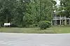 Dr. Lewis Barrett House |
July 24, 1980 (#80001539) |
2nd and Caldwell Sts. 37°16′20″N 85°53′21″W |
Munfordville | |
| 2 | Battle of Munfordville Site | 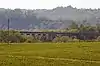 Battle of Munfordville Site |
October 15, 1999 (#97000866) |
Roughly bounded by Green River, U.S. Route 31W, Rowletts, and the L&N railroad tracks 37°15′31″N 85°53′28″W |
Munfordville | |
| 3 | Chapline Building | 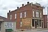 Chapline Building |
July 24, 1980 (#80001540) |
Main St. 37°16′15″N 85°53′23″W |
Munfordville | |
| 4 | Alvey Cox House | 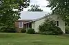 Alvey Cox House |
July 24, 1980 (#80001541) |
1st and Washington Sts. 37°16′11″N 85°53′21″W |
Munfordville | |
| 5 | Gardner House | 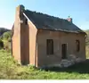 Gardner House |
August 4, 2004 (#04000794) |
Farm lane on the northern side of W. Walker Rd. 37°14′17″N 85°59′44″W |
Northtown | |
| 6 | Hart County Courthouse | 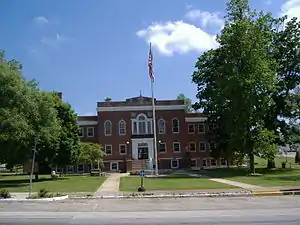 Hart County Courthouse |
July 24, 1980 (#80001542) |
Town Sq. 37°16′19″N 85°53′25″W |
Munfordville | |
| 7 | Hart County Deposit Bank and Trust Company Building | 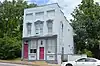 Hart County Deposit Bank and Trust Company Building |
July 24, 1980 (#80001543) |
Main St. 37°16′20″N 85°53′28″W |
Munfordville | |
| 8 | Horse Cave Historic District |  Horse Cave Historic District |
August 2, 2001 (#01000796) |
Kentucky Route 218, roughly between U.S. Route 31W and Edwards Ave. 37°10′44″N 85°54′22″W |
Horse Cave | |
| 9 | Munford Inn | 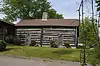 Munford Inn |
March 19, 1984 (#84001615) |
109 Washington St. 37°16′13″N 85°53′23″W |
Munfordville | |
| 10 | Munfordville Baptist Church |  Munfordville Baptist Church |
July 24, 1980 (#80001544) |
313 S. 5th St. 37°16′17″N 85°53′41″W |
Munfordville | |
| 11 | Munfordville Presbyterian Church and Green River Lodge No.88 | 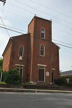 Munfordville Presbyterian Church and Green River Lodge No.88 |
July 24, 1980 (#80001545) |
3rd and Washington Sts. 37°16′17″N 85°53′30″W |
Munfordville | |
| 12 | Munfordville School | 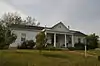 Munfordville School |
March 19, 1984 (#84001613) |
3rd and Washington Sts. 37°16′16″N 85°53′32″W |
Munfordville | |
| 13 | Pearce-Wheeler Farm | November 25, 2005 (#05001317) |
640 Sims Cemetery Rd. 37°18′46″N 85°43′02″W |
Canmer | ||
| 14 | Salts Cave Archeological Site | May 15, 1979 (#79000278) |
Address restricted[5] |
Munfordville | ||
| 15 | Colonel Robert A. Smith Monument | July 17, 1997 (#97000693) |
Along CSX railroad tracks, 0.25 miles west of Woodsonville 37°15′27″N 85°53′46″W |
Munfordville | ||
| 16 | F.A. Smith House | 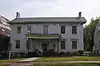 F.A. Smith House |
July 24, 1980 (#80001546) |
204 N. Washington St. 37°16′14″N 85°53′30″W |
Munfordville | |
| 17 | Unknown Confederate Soldier Monument in Horse Cave | 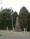 Unknown Confederate Soldier Monument in Horse Cave |
July 17, 1997 (#97000694) |
Old Dixie Highway, 1 mile south of its junction with Interstate 65 37°11′37″N 85°55′37″W |
Horse Cave | |
| 18 | Gen. George T. Wood House | 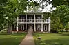 Gen. George T. Wood House |
July 24, 1980 (#80001547) |
2nd and Caldwell Sts. 37°16′22″N 85°53′20″W |
Munfordville |
See also
| Wikimedia Commons has media related to National Register of Historic Places in Hart County, Kentucky. |
References
- The latitude and longitude information provided in this table was derived originally from the National Register Information System, which has been found to be fairly accurate for about 99% of listings. Some locations in this table may have been corrected to current GPS standards.
- "National Register of Historic Places: Weekly List Actions". National Park Service, United States Department of the Interior. Retrieved on February 5, 2021.
- Numbers represent an alphabetical ordering by significant words. Various colorings, defined here, differentiate National Historic Landmarks and historic districts from other NRHP buildings, structures, sites or objects.
- The eight-digit number below each date is the number assigned to each location in the National Register Information System database, which can be viewed by clicking the number.
- Federal and state laws and practices restrict general public access to information regarding the specific location of this resource. In some cases, this is to protect archeological sites from vandalism, while in other cases it is restricted at the request of the owner. See: Knoerl, John; Miller, Diane; Shrimpton, Rebecca H. (1990), Guidelines for Restricting Information about Historic and Prehistoric Resources, National Register Bulletin, National Park Service, U.S. Department of the Interior, OCLC 20706997.
| Topics | |
|---|---|
| Lists by state |
|
| Lists by insular areas | |
| Lists by associated state | |
| Other areas | |
| Related | |
| |
Municipalities and communities of Hart County, Kentucky, United States | ||
|---|---|---|
| Cities | Location of Hart County, Kentucky | |
| CDP | ||
| Other unincorporated communities | ||
| ||
This article is issued from Wikipedia. The text is licensed under Creative Commons - Attribution - Sharealike. Additional terms may apply for the media files.