National Register of Historic Places listings in Christian County, Kentucky
This is a list of the National Register of Historic Places listings in Christian County, Kentucky.

Location of Christian County in Kentucky
This is intended to be a complete list of the properties and districts on the National Register of Historic Places in Christian County, Kentucky, United States. The locations of National Register properties and districts for which the latitude and longitude coordinates are included below, may be seen in a map.[1]
There are 49 properties and districts listed on the National Register in the county.
- This National Park Service list is complete through NPS recent listings posted February 5, 2021.[2]
Current listings
| [3] | Name on the Register | Image | Date listed[4] | Location | City or town | Description |
|---|---|---|---|---|---|---|
| 1 | Alumni-Latham-Mooreland Historic District | 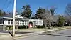 Alumni-Latham-Mooreland Historic District |
July 22, 1993 (#93000696) |
Alumni Ave., Latham Ave., and Mooreland Dr. 36°51′15″N 87°29′47″W |
Hopkinsville | |
| 2 | Attucks High School | 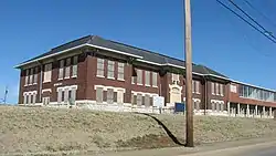 Attucks High School |
January 23, 2013 (#12001199) |
712 E. 1st. St. 36°52′08″N 87°28′41″W |
Hopkinsville | |
| 3 | C.A. Baldwin Farmstead | September 29, 2015 (#15000648) |
2680 Masonville-Beverly Rd. 36°45′54″N 87°30′57″W |
Hopkinsville | ||
| 4 | Beverly School | April 30, 1979 (#79003624) |
Off Kentucky Route 107 36°45′43″N 87°31′29″W |
Hopkinsville | ||
| 5 | Blue Lantern Farm | April 30, 1979 (#79003626) |
U.S. Route 68 36°52′25″N 87°31′18″W |
Hopkinsville | ||
| 6 | Boatright House | April 30, 1979 (#79003611) |
Off U.S. Route 41 36°50′49″N 87°26′55″W |
Hopkinsville | ||
| 7 | Bradshaw House | April 30, 1979 (#79003623) |
Off Kentucky Route 107 36°45′44″N 87°31′19″W |
Hopkinsville | ||
| 8 | Campbell House | April 30, 1979 (#79003627) |
Junction of Kentucky Routes 164 and 272 36°51′30″N 87°33′49″W |
Hopkinsville | ||
| 9 | Cedar Grove | November 17, 1977 (#77000608) |
East of Oak Grove off Kentucky Route 115 36°39′15″N 87°22′36″W |
Oak Grove | ||
| 10 | Church Hill Grange Hall | August 28, 1975 (#75000744) |
5.5 miles (8.9 km) southwest of Hopkinsville on Cox Mill Rd. (Kentucky Route 695) 36°47′58″N 87°34′28″W |
Hopkinsville | ||
| 11 | Confederate Memorial Fountain in Hopkinsville | 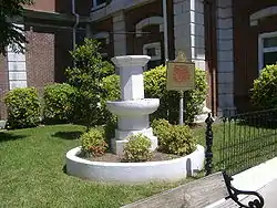 Confederate Memorial Fountain in Hopkinsville |
July 17, 1997 (#97000710) |
3 blocks north of the junction of U.S. Route 41 and Main St. 36°52′00″N 87°29′17″W |
Hopkinsville | |
| 12 | Cox House | April 30, 1979 (#79003615) |
South of Kentucky Route 272 36°49′06″N 87°40′22″W |
Julien | ||
| 13 | Judge Joseph Crockett House | 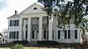 Judge Joseph Crockett House |
April 3, 1979 (#79000968) |
317 E. 16th St. 36°51′38″N 87°29′18″W |
Hopkinsville | |
| 14 | Dalton Brick Company | April 30, 1979 (#79003606) |
N. Elm St.[5] 36°52′26″N 87°29′25″W |
Hopkinsville | ||
| 15 | Monroe Dalton House | 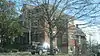 Monroe Dalton House |
February 10, 1983 (#83002624) |
713 E. 7th St. 36°51′49″N 87°28′56″W |
Hopkinsville | |
| 16 | East 7th Street Historic District | 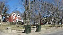 East 7th Street Historic District |
September 7, 1983 (#83000561) |
Roughly bounded by E. 7th St. from Campbell to Belmont Sts. 36°51′49″N 87°28′52″W |
Hopkinsville | |
| 17 | Elk Grove Farm | April 30, 1979 (#79003613) |
Off U.S. Route 41A 36°45′37″N 87°27′37″W |
Hopkinsville | ||
| 18 | Elliott Place | April 30, 1979 (#79003617) |
North of Lafayette Rd. 36°39′31″N 87°37′43″W |
LaFayette | ||
| 19 | Fairelond | 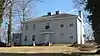 Fairelond |
September 7, 1983 (#83000562) |
1303 E. 7th St. 36°51′45″N 87°28′29″W |
Hopkinsville | |
| 20 | Freeman Chapel C.M.E. Church | 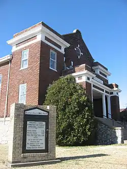 Freeman Chapel C.M.E. Church |
May 26, 1983 (#83000563) |
137 S. Virginia St. 36°52′08″N 87°29′08″W |
Hopkinsville | |
| 21 | Simon French House | April 30, 1979 (#79003622) |
Carter Rd., South of Barkers Mill 36°39′10″N 87°21′32″W |
Hensleytown | ||
| 22 | John C. Gary House | April 30, 1979 (#79003629) |
Gary Lane, south of Kentucky Route 695 36°48′45″N 87°31′45″W |
Hopkinsville | ||
| 23 | Genoa | April 30, 1979 (#79003619) |
Palmyra Rd. 36°43′09″N 87°31′54″W |
Howel | ||
| 24 | Glen Burnie | April 30, 1979 (#79003618) |
Bumpus Mill Rd. 36°41′00″N 87°23′30″W |
Hopkinsville | ||
| 25 | Grace Episcopal Church | .jpg.webp) Grace Episcopal Church |
January 28, 1982 (#82002679) |
220 E. 6th St. 36°51′59″N 87°29′09″W |
Hopkinsville | |
| 26 | E.H. Higgins House | 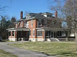 E.H. Higgins House |
January 3, 1984 (#84001403) |
1530 E. 7th St. 36°51′55″N 87°28′08″W |
Hopkinsville | |
| 27 | Hopkinsville Commercial Historic District |  Hopkinsville Commercial Historic District |
April 30, 1979 (#79003633) |
Roughly bounded by the L&N railroad line and 10th, 5th, and Bethel Sts. 36°51′56″N 87°29′13″W |
Hopkinsville | |
| 28 | Hopkinsville L & N Railroad Depot | 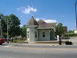 Hopkinsville L & N Railroad Depot |
August 1, 1975 (#75000745) |
425 E. 9th St. 36°51′49″N 87°29′07″W |
Hopkinsville | |
| 29 | Hopkinsville Residential Historic District |  Hopkinsville Residential Historic District |
April 30, 1979 (#79003631) |
Roughly bounded by 14th, 20th, Main, and Virginia Sts.; also the southwestern corner of Main and 13th Sts. 36°51′38″N 87°29′30″W |
Hopkinsville | Second address represents a boundary increase |
| 30 | Hopkinsville Warehouse Historic District | 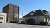 Hopkinsville Warehouse Historic District |
April 30, 1979 (#79003632) |
Roughly along Harrison St. and railroad tracks from 2nd to 21st Sts. 36°51′32″N 87°29′11″W |
Hopkinsville | |
| 31 | Hopper Court | 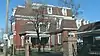 Hopper Court |
April 30, 1979 (#79003605) |
Hopper Ct. 36°51′27″N 87°29′24″W |
Hopkinsville | |
| 32 | J.B. Knight House | 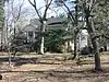 J.B. Knight House |
April 30, 1979 (#79003607) |
1417 E. 7th St. 36°51′32″N 87°29′11″W |
Hopkinsville | |
| 33 | Lafayette Methodist Church | 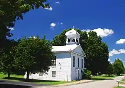 Lafayette Methodist Church |
April 30, 1979 (#79003616) |
Off Kentucky Route 107 36°39′36″N 87°39′33″W |
LaFayette | |
| 34 | Latham Confederate Monument | 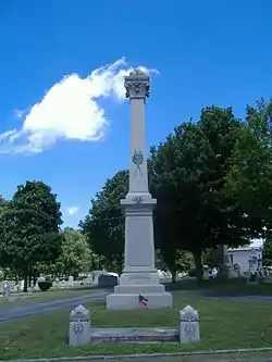 Latham Confederate Monument |
July 17, 1997 (#97000709) |
Riverside Cemetery, west of Hopkinsville between U.S. Route 41 and L&N railroad tracks. 36°52′31″N 87°28′53″W |
Hopkinsville | |
| 35 | Maplewood | April 30, 1979 (#79003625) |
Off Mason Lane 36°44′21″N 87°20′28″W |
Pembroke | ||
| 36 | McClellen House | April 30, 1979 (#79003621) |
Kentucky Route 508 36°53′13″N 87°20′00″W |
Honey Grove | ||
| 37 | McRay Site (15CH139) | February 3, 1983 (#83002625) |
Address Restricted |
Hopkinsville | ||
| 38 | Oakland/Henry House | April 30, 1979 (#79003628) |
Kentucky Route 164 36°49′04″N 87°36′05″W |
Hopkinsville | ||
| 39 | Pilot Rock Petroglyphs (15CH200) | September 8, 1989 (#89001179) |
Address Restricted |
Hopkinsville | ||
| 40 | Poston House | 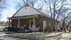 Poston House |
April 30, 1979 (#79003608) |
809 Hayes St. 36°52′02″N 87°28′41″W |
Hopkinsville | |
| 41 | Rich Grove | April 30, 1979 (#79003610) |
Off Kentucky Route 109, north of Highway 1027 36°46′22″N 87°26′13″W |
Hopkinsville | ||
| 42 | Ritter House | April 30, 1979 (#79003609) |
Off U.S. Route 41A 36°49′41″N 87°28′56″W |
Hopkinsville | ||
| 43 | Smokehouse on Riverside Creek | January 8, 1987 (#87000166) |
Petsch Ln. off Kentucky Route 272 36°51′51″N 87°34′50″W |
Hopkinsville | ||
| 44 | Dr. Edward S. Stewart House | 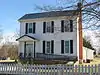 Dr. Edward S. Stewart House |
April 30, 1979 (#79003620) |
U.S. Route 68 36°50′34″N 87°18′10″W |
Fairview | |
| 45 | E.W. Walker House | 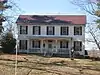 E.W. Walker House |
September 7, 1983 (#83000564) |
1414 E. 7th St. 36°51′52″N 87°28′18″W |
Hopkinsville | |
| 46 | Western Lunatic Asylum |  Western Lunatic Asylum |
April 30, 1979 (#79003612) |
U.S. Route 68 36°51′54″N 87°27′04″W |
Hopkinsville | |
| 47 | Whitepath and Fly Smith Gravesite | November 26, 2004 (#04001250) |
U.S. Route 41[6] 36°51′11″N 87°28′14″W |
Hopkinsville | ||
| 48 | Woodlawn | April 30, 1979 (#79003614) |
Off U.S. Route 41A 36°46′09″N 87°27′38″W |
Hopkinsville | ||
| 49 | Frank K. Yost House |  Frank K. Yost House |
September 7, 1983 (#83000565) |
1131 E. 7th St. 36°51′44″N 87°28′35″W |
Hopkinsville |
See also
| Wikimedia Commons has media related to National Register of Historic Places in Christian County, Kentucky. |
References
- The latitude and longitude information provided in this table was derived originally from the National Register Information System, which has been found to be fairly accurate for about 99% of listings. Some locations in this table may have been corrected to current GPS standards.
- "National Register of Historic Places: Weekly List Actions". National Park Service, United States Department of the Interior. Retrieved on February 5, 2021.
- Numbers represent an alphabetical ordering by significant words. Various colorings, defined here, differentiate National Historic Landmarks and historic districts from other NRHP buildings, structures, sites or objects.
- The eight-digit number below each date is the number assigned to each location in the National Register Information System database, which can be viewed by clicking the number.
- CMT-KTG. Kentucky Historic Resources Inventory: Dalton Brick Company. Kentucky Heritage Council, 1977.
- Thomason, Philip, and Teresa Douglass. National Register of Historic Places Inventory/Nomination: Whitepath and Fly Smith Gravesite. National Park Service, 2004-06-30, 1.
| Topics | |
|---|---|
| Lists by state |
|
| Lists by insular areas | |
| Lists by associated state | |
| Other areas | |
| Related | |
| |
Municipalities and communities of Christian County, Kentucky, United States | ||
|---|---|---|
| Cities | Location of Christian County, Kentucky | |
| CDPs | ||
| Unincorporated communities | ||
| Footnotes | ‡This populated place also has portions in an adjacent county or counties | |
| ||
This article is issued from Wikipedia. The text is licensed under Creative Commons - Attribution - Sharealike. Additional terms may apply for the media files.