National Register of Historic Places listings in Madison County, Kentucky
This is a list of the National Register of Historic Places listings in Madison County, Kentucky.
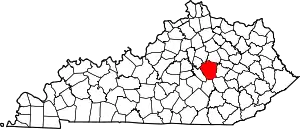
Location of Madison County in Kentucky
This is intended to be a complete list of the properties and districts on the National Register of Historic Places in Madison County, Kentucky, United States. The locations of National Register properties and districts for which the latitude and longitude coordinates are included below, may be seen in a map.[1]
There are 81 properties and districts listed on the National Register in the county; 2 of these are National Historic Landmarks.
- This National Park Service list is complete through NPS recent listings posted February 5, 2021.[2]
Current listings
| [3] | Name on the Register | Image | Date listed[4] | Location | City or town | Description |
|---|---|---|---|---|---|---|
| 1 | Archeological Site 15 Ma 24 | 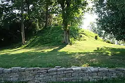 Archeological Site 15 Ma 24 |
August 18, 1980 (#80001651) |
At Round Hill[5] 37°40′46″N 84°25′00″W |
Round Hill | |
| 2 | Archeological Site No. 15MA25 | April 28, 1983 (#83002816) |
Address Restricted |
Bighill | ||
| 3 | Arlington | 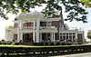 Arlington |
October 13, 1983 (#83003778) |
Lexington Rd. 37°45′40″N 84°19′19″W |
Richmond | |
| 4 | Battle of Richmond Historic Areas |  Battle of Richmond Historic Areas |
August 22, 1996 (#94000844) |
Two discontiguous areas: one northeast of the junction of U.S. Routes 25 and 421, and one southeast of the junction of U.S. Route 25 and Rose Ln. 37°40′10″N 84°15′07″W |
Richmond | |
| 5 | Berea College Forest |  Berea College Forest |
November 4, 2003 (#02000343) |
Kentucky Route 21, 2 miles (3.2 km) east of the Berea College campus 37°32′00″N 84°13′41″W |
Berea | |
| 6 | Berea College Square Commercial Historic District | December 9, 2020 (#100005899) |
Main St. (100 blk.), Short St. (200 blk.), Center St. (100 blk., 204 Center), Jackson St., (103-105) and Prospect St. 37°34′20″N 84°17′17″W |
Berea | ||
| 7 | Berea Downtown Commercial and Residential Historic District | December 10, 2020 (#100005909) |
Roughly bounded by Chestnut St. (300-400), North Broadway St. (100-200), Adams St. (200), Parkway Ave. (100), Pasco St. (100), and Bond St. 37°34′05″N 84°17′53″W |
Berea | ||
| 8 | Blair Park |  Blair Park |
October 13, 1983 (#83003779) |
108 Rosedale St. 37°45′16″N 84°18′27″W |
Richmond | |
| 9 | Blythewood |  Blythewood |
February 8, 1989 (#88003330) |
Junction of Peytontown and Duncanon Rds. 37°40′16″N 84°19′21″W |
Richmond | |
| 10 | Bogie Circle | March 28, 1983 (#83002814) |
Address Restricted |
Ruthton | ||
| 11 | Bogie Houses and Mill Site | August 13, 1976 (#76000920) |
8 miles (13 km) west of Richmond on Silver Creek 37°43′42″N 84°25′28″W |
Richmond | ||
| 12 | Boone Tavern Hotel |  Boone Tavern Hotel |
January 11, 1996 (#95001527) |
100 Main St. 37°34′19″N 84°17′19″W |
Berea | |
| 13 | Judge Daniel Breck House |  Judge Daniel Breck House |
November 7, 1976 (#76000921) |
312 Lancaster Ave. 37°44′47″N 84°18′00″W |
Richmond | |
| 14 | Bronston Place | 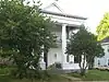 Bronston Place |
October 13, 1983 (#83003781) |
Woodland Ave. 37°45′06″N 84°17′41″W |
Richmond | |
| 15 | Burnamwood | 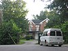 Burnamwood |
January 3, 1984 (#84001801) |
Burnam Ct. 37°45′07″N 84°18′21″W |
Richmond | |
| 16 | Campbell House | February 8, 1989 (#88003334) |
Kentucky Route 52 near Paint Lick 37°37′47″N 84°24′10″W |
Paint Lick | ||
| 17 | Cane Springs Primitive Baptist Church | December 22, 1978 (#78001381) |
North of College Hill 37°49′37″N 84°07′51″W |
College Hill | ||
| 18 | Chenault House | February 8, 1989 (#88003339) |
North of Richmond off Interstate 75 37°46′28″N 84°18′11″W |
Richmond | ||
| 19 | Churchill Weavers |  Churchill Weavers |
January 8, 2014 (#13001054) |
100 Churchill Dr. 37°34′42″N 84°16′52″W |
Berea | |
| 20 | Brutus and Pattie Field Clay House | 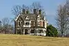 Brutus and Pattie Field Clay House |
June 13, 1990 (#88003341) |
Lexington Rd. west of Richmond 37°45′55″N 84°18′31″W |
Richmond | |
| 21 | Whitney Cobb House | February 8, 1989 (#88003312) |
Kentucky Route 388 37°50′26″N 84°15′48″W |
Richmond | ||
| 22 | Cornelison Mound | February 12, 1998 (#98000090) |
Address Restricted |
Ruthton | ||
| 23 | Cornelison Pottery | July 24, 1978 (#78001380) |
Kentucky Route 52 37°43′58″N 84°07′29″W |
Bybee | ||
| 24 | Covington House | February 8, 1989 (#88003329) |
Southwest of Richmond on Kentucky Route 595 37°41′17″N 84°20′12″W |
Richmond | ||
| 25 | Coy Site Complex | February 12, 1998 (#98000091) |
Address Restricted |
Richmond | ||
| 26 | Downtown Richmond Historic District |  Downtown Richmond Historic District |
September 30, 1976 (#76000922) |
Main St. and Courthouse Sq. 37°44′52″N 84°17′43″W |
Richmond | |
| 27 | Dozier-Guess House | May 1, 1989 (#88003343) |
Kentucky Route 388, Red House Rd. 37°47′02″N 84°16′28″W |
Richmond | ||
| 28 | Duncannon | September 17, 1980 (#80001650) |
South of Richmond on John Parrish Lane 37°40′38″N 84°17′46″W |
Richmond | ||
| 29 | Eastern Kentucky University Historic District | 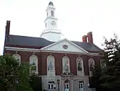 Eastern Kentucky University Historic District |
January 3, 1984 (#84001804) |
Lancaster, Crabbe Sts. and University Dr. 37°44′30″N 84°18′00″W |
Richmond | |
| 30 | Elk Garden | February 8, 1989 (#88003326) |
South of Kirksville off Kentucky Route 595 37°38′34″N 84°23′48″W |
Kirksville | ||
| 31 | Elmwood |  Elmwood |
August 6, 2012 (#84003927) |
Lancaster Ave. 37°44′38″N 84°18′11″W |
Richmond | |
| 32 | Farmers Bank of Kirksville | June 13, 1990 (#88003324) |
Near the junction of Kentucky Route 595 and County Road 1295 37°39′55″N 84°24′31″W |
Kirksville | ||
| 33 | Fort Boonesborough Townsite Historic District | 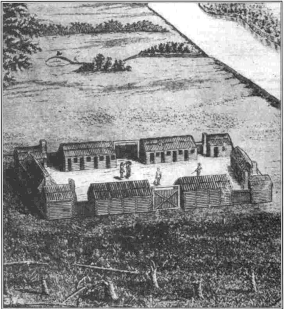 Fort Boonesborough Townsite Historic District |
April 14, 1994 (#94000303) |
4375 Old Boonesborough Rd. 37°53′18″N 84°16′03″W |
Richmond | |
| 34 | Griggs House | February 8, 1989 (#88003316) |
North of Waco 37°44′43″N 84°08′34″W |
Waco | ||
| 35 | Hagan House | February 8, 1989 (#88003337) |
Hagans Mill Rd. 37°41′29″N 84°21′46″W |
Richmond | ||
| 36 | Hakins-Stone-Hagan-Curtis House | February 8, 1989 (#88003327) |
1875 Curtis Pike 37°41′50″N 84°22′57″W |
Kirksville | ||
| 37 | Nathan Hawkins House | June 23, 1983 (#83002815) |
Curtis Rd. 37°41′46″N 84°23′08″W |
Kirksville | ||
| 38 | William Holloway House | 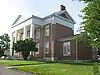 William Holloway House |
October 13, 1983 (#83003783) |
Hillsdale St. 37°44′45″N 84°17′18″W |
Richmond | |
| 39 | Homelands | February 8, 1989 (#88003332) |
Northwest of Richmond on U.S. Route 25 37°49′43″N 84°19′39″W |
Richmond | ||
| 40 | Irvinton | 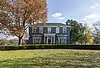 Irvinton |
May 6, 1975 (#75000798) |
319 Lancaster Ave. 37°44′40″N 84°17′58″W |
Richmond | |
| 41 | Merritt Jones Tavern |  Merritt Jones Tavern |
April 2, 1973 (#73000817) |
1 mile (1.6 km) south of Bighill on U.S. Route 421 37°39′05″N 84°45′32″W |
Bighill | |
| 42 | Karr House | February 8, 1989 (#88003313) |
Lost Fork Rd. 37°50′37″N 84°17′17″W |
Richmond | ||
| 43 | Kellogg and Company Warehouse | August 2, 2017 (#100001424) |
131 Orchard St. 37°44′43″N 84°17′11″W |
Richmond | ||
| 44 | Kirksville Christian Church | 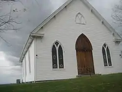 Kirksville Christian Church |
February 8, 1989 (#88003325) |
Kentucky Route 595 37°39′47″N 84°24′27″W |
Kirksville | |
| 45 | Lincoln Hall | .jpg.webp) Lincoln Hall |
December 2, 1974 (#74000892) |
Berea College campus 37°34′19″N 84°17′26″W |
Berea | |
| 46 | Louisville and Nashville Railroad Passenger Depot | 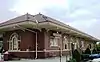 Louisville and Nashville Railroad Passenger Depot |
August 22, 1975 (#75000797) |
Broadway at Adams St. 37°34′17″N 84°17′58″W |
Berea | |
| 47 | Madison County Courthouse | 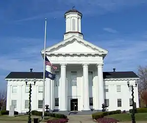 Madison County Courthouse |
May 12, 1975 (#75000800) |
Main St. between N. 1st and N. 2nd Sts. 37°44′51″N 84°16′59″W |
Richmond | |
| 48 | Mason House | February 8, 1989 (#88003320) |
South of Richmond off Meneleus Pike 37°39′25″N 84°18′27″W |
Richmond | ||
| 49 | William M. Miller Farm | January 4, 2001 (#00001599) |
1099 Parrish Rd. 37°40′18″N 84°17′35″W |
Richmond | ||
| 50 | William M. Miller House | July 16, 1979 (#79003602) |
South of Richmond 37°40′08″N 84°17′45″W |
Richmond | ||
| 51 | Moberly House | February 8, 1989 (#88003315) |
0.3 miles (0.48 km) north of Old Kentucky Route 52 37°44′43″N 84°09′58″W |
Moberly | ||
| 52 | John Moberly House | June 23, 1983 (#83002817) |
Gum Bottom Rd. 37°39′41″N 84°10′40″W |
Moberly | ||
| 53 | Morrison House | February 8, 1989 (#88003340) |
East of Kirksville off Kentucky Route 595 37°39′38″N 84°23′16″W |
Kirksville | ||
| 54 | Mt. Pleasant | 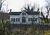 Mt. Pleasant |
October 13, 1983 (#83003784) |
2nd and Water Sts. 37°44′46″N 84°17′44″W |
Richmond | |
| 55 | Mt. Pleasant Christian Church | February 8, 1989 (#88003331) |
North of Richmond on U.S. Route 25 37°50′16″N 84°19′35″W |
Richmond | ||
| 56 | Mt. Zion Christian Church | 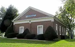 Mt. Zion Christian Church |
February 8, 1989 (#88003318) |
U.S. Route 421 south of its junction with U.S. Route 25 37°40′25″N 84°15′14″W |
Richmond | |
| 57 | Stephen Murphy House | June 23, 1983 (#83002818) |
Off Kentucky Route 39 37°45′30″N 84°30′40″W |
Little Hickman | ||
| 58 | Isaac Newland House | June 23, 1983 (#83002819) |
Off U.S. Route 25 37°47′55″N 84°19′56″W |
Richmond | ||
| 59 | Noland Mound (15-Ma-14) | January 27, 1983 (#83002820) |
Address Restricted |
Richmond | ||
| 60 | Old Central University | 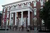 Old Central University |
June 19, 1973 (#73000818) |
University Dr. on Eastern Kentucky University campus 37°44′27″N 84°18′04″W |
Richmond | |
| 61 | Richmond Armory | 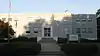 Richmond Armory |
March 24, 2000 (#00000282) |
Junction of 2nd St. and Moberly Ave. 37°45′04″N 84°17′32″W |
Richmond | |
| 62 | Richmond Cemetery |  Richmond Cemetery |
October 13, 1983 (#83003785) |
E. Main St. 37°44′32″N 84°17′23″W |
Richmond | |
| 63 | Robbins Mound | February 12, 1998 (#98000092) |
Address Restricted |
Ruthton | ||
| 64 | Rolling Meadows | February 8, 1989 (#88003321) |
Kentucky Route 595 north of Round Hill 37°41′27″N 84°25′29″W |
Round Hill | ||
| 65 | Shearer Store | June 13, 1990 (#88003314) |
Kentucky Route 1936 at Union City 37°47′52″N 84°11′51″W |
Richmond | ||
| 66 | Simmons House | February 8, 1989 (#88003323) |
Arbuckle Lane off County Road 1295 37°41′14″N 84°23′13″W |
Richmond | ||
| 67 | Stephenson House | February 8, 1989 (#88003322) |
North of Round Hill on Kentucky Route 595 37°40′57″N 84°25′05″W |
Round Hill | ||
| 68 | Tate Building | 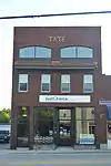 Tate Building |
September 13, 2006 (#06000814) |
444 Chestnut St. 37°34′05″N 84°17′55″W |
Berea | |
| 69 | Tates Creek Baptist Church | February 8, 1989 (#88003333) |
Kentucky Route 627/Boonesborough Rd. 37°50′49″N 84°19′06″W |
Richmond | ||
| 70 | Taylor House | February 8, 1989 (#88003336) |
North of Baldwin 37°48′24″N 84°25′49″W |
Baldwin | ||
| 71 | Taylor House |  Taylor House |
October 13, 1983 (#83003787) |
216 Water St. 37°44′49″N 84°17′47″W |
Richmond | |
| 72 | Tevis House | February 8, 1989 (#88003335) |
Kentucky Route 627/Boonesborough Rd. 37°51′24″N 84°17′32″W |
Richmond | ||
| 73 | Turner House | February 8, 1989 (#88003338) |
Southeast of Richmond on Curtis Pike 37°42′01″N 84°22′24″W |
Richmond | ||
| 74 | Turner-Fitzpatrick House | February 8, 1989 (#88003328) |
Off Mule Shed Rd. 37°44′26″N 84°21′46″W |
Richmond | ||
| 75 | Squire Turner House | 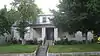 Squire Turner House |
October 13, 1983 (#83003786) |
302 N. 2nd St. 37°44′46″N 84°17′44″W |
Richmond | |
| 76 | Union Bus Station | 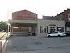 Union Bus Station |
April 10, 2007 (#07000285) |
127 S. 3rd St. 37°44′58″N 84°17′49″W |
Richmond | |
| 77 | Viney Fork Baptist Church | February 8, 1989 (#88003317) |
Junction of County Roads 374 and 499 37°40′26″N 84°10′38″W |
Speedwell | ||
| 78 | Walker House | 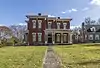 Walker House |
October 13, 1983 (#83003789) |
315 Lancaster Ave. 37°44′45″N 84°17′57″W |
Richmond | |
| 79 | William Walker House | February 8, 1989 (#88003319) |
Duncannon Rd. 37°40′44″N 84°18′27″W |
Richmond | ||
| 80 | West Richmond Historic District | 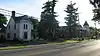 West Richmond Historic District |
January 12, 1984 (#84001815) |
Roughly W. Main St. between Church and Norwood Sts. 37°44′59″N 84°18′00″W |
Richmond | |
| 81 | Whitehall | 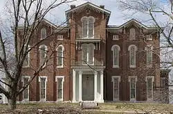 Whitehall |
March 11, 1971 (#71000352) |
7 miles (11 km) north of Richmond on Clay Lane off U.S. Route 25 37°49′58″N 84°21′08″W |
Richmond |
See also
| Wikimedia Commons has media related to National Register of Historic Places in Madison County, Kentucky. |
References
- The latitude and longitude information provided in this table was derived originally from the National Register Information System, which has been found to be fairly accurate for about 99% of listings. Some locations in this table may have been corrected to current GPS standards.
- "National Register of Historic Places: Weekly List Actions". National Park Service, United States Department of the Interior. Retrieved on February 5, 2021.
- Numbers represent an alphabetical ordering by significant words. Various colorings, defined here, differentiate National Historic Landmarks and historic districts from other NRHP buildings, structures, sites or objects.
- The eight-digit number below each date is the number assigned to each location in the National Register Information System database, which can be viewed by clicking the number.
- "National Register Information System". National Register of Historic Places. National Park Service. July 9, 2010.
| Topics | |
|---|---|
| Lists by state |
|
| Lists by insular areas | |
| Lists by associated state | |
| Other areas | |
| Related | |
| |
Municipalities and communities of Madison County, Kentucky, United States | ||
|---|---|---|
| Cities | Location of Madison County, Kentucky | |
| Unincorporated communities |
| |
| ||
This article is issued from Wikipedia. The text is licensed under Creative Commons - Attribution - Sharealike. Additional terms may apply for the media files.