Ars, Creuse
Ars is a commune in the Creuse department in the Nouvelle-Aquitaine region in central France.
Ars | |
|---|---|
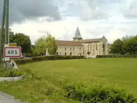 The church of Saint-Barthélemy, in Ars | |
Location of Ars 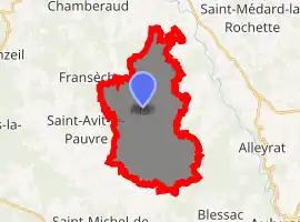
| |
 Ars  Ars | |
| Coordinates: 46°00′18″N 2°04′45″E | |
| Country | France |
| Region | Nouvelle-Aquitaine |
| Department | Creuse |
| Arrondissement | Guéret |
| Canton | Ahun |
| Intercommunality | CC Creuse Sud Ouest |
| Government | |
| • Mayor (2014-2020) | Denis Sarty |
| Area 1 | 21.69 km2 (8.37 sq mi) |
| Population (2017-01-01)[1] | 244 |
| • Density | 11/km2 (29/sq mi) |
| Time zone | UTC+01:00 (CET) |
| • Summer (DST) | UTC+02:00 (CEST) |
| INSEE/Postal code | 23007 /23480 |
| Elevation | 427–625 m (1,401–2,051 ft) (avg. 560 m or 1,840 ft) |
| 1 French Land Register data, which excludes lakes, ponds, glaciers > 1 km2 (0.386 sq mi or 247 acres) and river estuaries. | |
Geography
An area of lakes, forestry and farming comprising the village and several hamlets situated by the banks of the small river Voutouéry, some 5 miles (8.0 km) northwest of Aubusson at the junction of the D55, D54 and the D7 roads.
Population
| Year | Pop. | ±% |
|---|---|---|
| 1962 | 275 | — |
| 1968 | 336 | +22.2% |
| 1975 | 265 | −21.1% |
| 1982 | 250 | −5.7% |
| 1990 | 247 | −1.2% |
| 1999 | 247 | +0.0% |
| 2008 | 252 | +2.0% |
| 2015 | 257 | +2.0% |
Sights
- The church, dating from the thirteenth century.
- The ruins of the castle of Ars.
- A chapel, dating from the sixteenth century.
See also
References
- "Populations légales 2017". INSEE. Retrieved 6 January 2020.
External links
- Ars on the Quid website (in French)
| Wikimedia Commons has media related to Ars (Creuse). |
| Authority control |
|---|
This article is issued from Wikipedia. The text is licensed under Creative Commons - Attribution - Sharealike. Additional terms may apply for the media files.
